
Brown County, Texas facts for kids
Quick facts for kids
Brown County
|
|
|---|---|

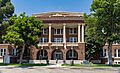
The Brown County Courthouse in Brownwood
|
|

Location within the U.S. state of Texas
|
|
 Texas's location within the U.S. |
|
| Country | |
| State | |
| Founded | 1858 |
| Named for | Henry Stevenson Brown |
| Seat | Brownwood |
| Largest city | Brownwood |
| Area | |
| • Total | 957 sq mi (2,480 km2) |
| • Land | 944 sq mi (2,440 km2) |
| • Water | 13 sq mi (30 km2) 1.3% |
| Population
(2020)
|
|
| • Total | 38,095 |
| • Density | 40/sq mi (20/km2) |
| Time zone | UTC−6 (Central) |
| • Summer (DST) | UTC−5 (CDT) |
| Congressional district | 11th |
Brown County is a county located in central Texas. As of the 2020 census, about 38,095 people lived there. The main city and government center is Brownwood. The county was started in 1856 and officially organized in 1858. It is named after Henry Stevenson Brown, who was a leader in an early conflict between Texans and Mexicans. Brown County is also part of the Brownwood, TX Micropolitan Statistical Area, which means it's a small city area with strong economic ties.
Contents
History of Brown County
For thousands of years before Europeans arrived, Indigenous peoples lived in this area. The Penteka people, also known as Comanche, were living here when European settlers first came.
In 1721, a Spanish journey led by the Marqués de San Miguel de Aguayo is believed to have traveled through what is now Brown County.
Early Settlers and County Formation
In 1838, people began surveying the land to map it out. In 1856, Welcome W. Chandler from Mississippi became the first settler. He arrived with his family and built a log cabin near Pecan Bayou. Brown County was created from parts of Comanche and Travis Counties. It was named after Henry Stevenson Brown, an American pioneer from Kentucky. In 1858, the county was officially set up, and Brownwood was chosen as its main city.
Challenges and Growth
In 1875, the stagecoach route between Fort Worth and Brownwood was robbed five times in just two months. Oil was found on a farm near Grosvenor in 1879. In 1886, Texas Rangers stopped two people who were cutting fences. This was part of a bigger disagreement between farmers and ranchers about fencing off open land. By the next year, cotton became the most important crop in the county. The Fort Worth and Rio Grande Railway reached the county in 1892. The Gulf, Colorado and Santa Fe Railway arrived in Brownwood in 1895 and later extended its line to Menard in 1903.
Also in 1903, the county voted to become a "dry county," meaning alcohol sales were not allowed. This rule lasted until the 1950s.
Economic Changes and World War II
In 1909, the boll weevil, a small beetle, damaged the cotton crops, which hurt the county's economy. The first commercial oil production started in Brownwood in 1917. A large oil field began producing oil in 1919 near Cross Cut. In 1926, there was a big oil boom, and many new wells were drilled. By 1991, over 50 million barrels of oil had been taken from Brown County lands since 1917.
In 1940, work began on Camp Bowie, a military training camp. During World War II, German prisoners of war arrived in 1943. Many of them had been part of Erwin Rommel's Afrika Korps.
Education Milestones
In 1889, two colleges, Howard Payne College and Daniel Baker College, were started in Brownwood. They later joined together in 1953 under the name Howard Payne College.
Geography of Brown County
The U.S. Census Bureau states that Brown County covers a total area of 957 square miles. About 13 square miles (1.3%) of this area is covered by water.
Major Highways in Brown County
 U.S. Highway 67
 U.S. Highway 84
 U.S. Highway 183
 U.S. Highway 377
 State Highway 279
 Farm to Market Road 45
Neighboring Counties
Brown County shares borders with these other counties:
- Eastland County (north)
- Comanche County (northeast)
- Mills County (southeast)
- San Saba County (south)
- McCulloch County (southwest)
- Coleman County (west)
- Callahan County (northwest)
Population and People
| Historical population | |||
|---|---|---|---|
| Census | Pop. | %± | |
| 1860 | 244 | — | |
| 1870 | 544 | 123.0% | |
| 1880 | 8,414 | 1,446.7% | |
| 1890 | 11,421 | 35.7% | |
| 1900 | 16,019 | 40.3% | |
| 1910 | 22,935 | 43.2% | |
| 1920 | 21,682 | −5.5% | |
| 1930 | 26,382 | 21.7% | |
| 1940 | 25,924 | −1.7% | |
| 1950 | 28,607 | 10.3% | |
| 1960 | 24,728 | −13.6% | |
| 1970 | 25,877 | 4.6% | |
| 1980 | 33,057 | 27.7% | |
| 1990 | 34,371 | 4.0% | |
| 2000 | 37,674 | 9.6% | |
| 2010 | 38,106 | 1.1% | |
| 2020 | 38,095 | 0.0% | |
| 2024 (est.) | 38,631 | 1.4% | |
| U.S. Decennial Census 1850–2010 2010 2020 |
|||
| Race / Ethnicity (NH = Non-Hispanic) | Pop 2000 | Pop 2010 | Pop 2020 | % 2000 | % 2010 | % 2020 |
|---|---|---|---|---|---|---|
| White alone (NH) | 29,772 | 28,478 | 26,672 | 79.03% | 74.73% | 70.01% |
| Black or African American alone (NH) | 1,473 | 1,303 | 1,353 | 3.91% | 3.42% | 3.55% |
| Native American or Alaska Native alone (NH) | 141 | 170 | 134 | 0.37% | 0.45% | 0.35% |
| Asian alone (NH) | 129 | 160 | 269 | 0.34% | 0.42% | 0.71% |
| Pacific Islander alone (NH) | 2 | 14 | 27 | 0.01% | 0.04% | 0.07% |
| Other Race alone (NH) | 13 | 36 | 96 | 0.03% | 0.09% | 0.25% |
| Mixed Race or Multiracial (NH) | 351 | 492 | 1,333 | 0.93% | 1.29% | 3.50% |
| Hispanic or Latino (any race) | 5,793 | 7,453 | 8,211 | 15.38% | 15.95% | 21.55% |
| Total | 37,674 | 38,106 | 38,095 | 100.00% | 100.00% | 100.00% |
In 2000, there were 37,674 people living in Brown County. The population density was about 40 people per square mile. Most people (87.35%) were White, 4.01% were Black or African American, and 15.38% were Hispanic or Latino.
About 31.40% of households had children under 18. The average household had 2.48 people. The median age in the county was 37 years old. The median income for a household was $30,974. About 17.20% of the population lived below the poverty line.
Local Media
The Brownwood Bulletin is the daily newspaper for the area. It also has an online website. Brown County is part of the Abilene, Sweetwater, and Brownwood television market. Local TV stations include KRBC-TV, KTXS-TV, KXVA, KTAB-TV, and KIDU-LD.
Communities in Brown County
Cities
Town
Census-Designated Places
These are areas that are like towns but not officially incorporated as cities:
Unincorporated Communities
These are smaller communities that are not officially part of a city or town:
- Brookesmith
- Cross Cut
- Grosvenor
- Indian Creek
- Owens
- Winchell
Ghost Towns
These are places where people used to live, but now they are mostly empty:
- Byrds
- Dulin
- Fry
- Thrifty
Politics and Voting
Brown County is a strong supporter of the Republican Party. The last time the county voted for a Democratic president was in 1976 for Jimmy Carter.
| Year | Republican | Democratic | Third party | |||
|---|---|---|---|---|---|---|
| No. | % | No. | % | No. | % | |
| 2024 | 14,593 | 86.59% | 2,132 | 12.65% | 128 | 0.76% |
| 2020 | 13,698 | 85.78% | 2,107 | 13.19% | 164 | 1.03% |
| 2016 | 12,017 | 85.68% | 1,621 | 11.56% | 388 | 2.77% |
| 2012 | 11,895 | 85.29% | 1,904 | 13.65% | 148 | 1.06% |
| 2008 | 12,052 | 79.95% | 2,822 | 18.72% | 200 | 1.33% |
| 2004 | 11,640 | 81.67% | 2,523 | 17.70% | 90 | 0.63% |
| 2000 | 9,609 | 74.37% | 3,138 | 24.29% | 173 | 1.34% |
| 1996 | 6,524 | 55.35% | 4,138 | 35.11% | 1,125 | 9.54% |
| 1992 | 5,313 | 42.07% | 4,264 | 33.76% | 3,053 | 24.17% |
| 1988 | 6,810 | 58.68% | 4,763 | 41.04% | 33 | 0.28% |
| 1984 | 8,468 | 67.29% | 4,070 | 32.34% | 47 | 0.37% |
| 1980 | 6,515 | 56.41% | 4,867 | 42.14% | 167 | 1.45% |
| 1976 | 4,483 | 44.41% | 5,577 | 55.25% | 35 | 0.35% |
| 1972 | 5,990 | 72.76% | 2,171 | 26.37% | 72 | 0.87% |
| 1968 | 2,997 | 34.84% | 3,999 | 46.49% | 1,606 | 18.67% |
| 1964 | 2,070 | 28.38% | 5,214 | 71.49% | 9 | 0.12% |
| 1960 | 3,512 | 48.26% | 3,720 | 51.11% | 46 | 0.63% |
| 1956 | 3,664 | 53.26% | 3,195 | 46.44% | 21 | 0.31% |
| 1952 | 4,635 | 55.02% | 3,778 | 44.85% | 11 | 0.13% |
| 1948 | 1,071 | 16.53% | 5,059 | 78.06% | 351 | 5.42% |
| 1944 | 430 | 12.13% | 2,426 | 68.45% | 688 | 19.41% |
| 1940 | 663 | 12.76% | 4,523 | 87.06% | 9 | 0.17% |
| 1936 | 448 | 10.05% | 3,971 | 89.08% | 39 | 0.87% |
| 1932 | 330 | 7.54% | 4,024 | 91.98% | 21 | 0.48% |
| 1928 | 2,033 | 50.46% | 1,992 | 49.44% | 4 | 0.10% |
| 1924 | 396 | 9.99% | 3,467 | 87.48% | 100 | 2.52% |
| 1920 | 397 | 16.30% | 1,708 | 70.11% | 331 | 13.59% |
| 1916 | 181 | 7.95% | 1,986 | 87.22% | 110 | 4.83% |
| 1912 | 115 | 6.81% | 1,433 | 84.84% | 141 | 8.35% |
| Year | Republican | Democratic | Third party(ies) | |||
|---|---|---|---|---|---|---|
| No. | % | No. | % | No. | % | |
| 2024 | 14,108 | 84.08% | 2,359 | 14.06% | 313 | 1.87% |
Education in Brown County
The county has several school districts:
- Bangs Independent School District
- Blanket Independent School District
- Brookesmith Independent School District
- Brownwood Independent School District
- Cross Plains Independent School District
- Early Independent School District
- May Independent School District
- Mullin Independent School District
- Rising Star Independent School District
- Zephyr Independent School District
For college-level education, the community college serving Brown County is Ranger Junior College District.
Images for kids
-
The Brown County Courthouse in Brownwood
See also
 In Spanish: Condado de Brown (Texas) para niños
