Buffalo County, Nebraska facts for kids
Quick facts for kids
Buffalo County
|
|
|---|---|

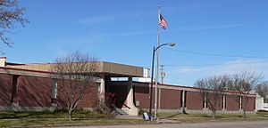
Buffalo County Courthouse in Kearney
|
|

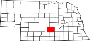
Location within the U.S. state of Nebraska
|
|
 Nebraska's location within the U.S. |
|
| Country | |
| State | |
| Founded | 1855 (authorized) 1870 (organized) |
| Named for | American bison |
| Seat | Kearney |
| Largest city | Kearney |
| Area | |
| • Total | 975 sq mi (2,530 km2) |
| • Land | 968 sq mi (2,510 km2) |
| • Water | 7.3 sq mi (19 km2) 0.7%% |
| Population
(2020)
|
|
| • Total | 50,084 |
| • Density | 51.368/sq mi (19.833/km2) |
| Time zone | UTC−6 (Central) |
| • Summer (DST) | UTC−5 (CDT) |
| Congressional district | 3rd |
Buffalo County is a special area called a county in the state of Nebraska, located in the central part of the United States. In 2020, about 50,084 people lived here. This makes it the fifth largest county in Nebraska by population. The main city and government center of the county is Kearney. Buffalo County was officially created in 1855 and started its government in 1870. It got its name from the many buffalo that used to roam the Great Plains.
Buffalo County is also part of the Kearney Micropolitan Statistical Area, which is a group of nearby towns and cities that are connected.
If you look at Nebraska license plates, cars from Buffalo County have the number 9. This system started in 1922. At that time, Buffalo County had the ninth-highest number of registered vehicles in the state.
Contents
History of Buffalo County
How Buffalo County Was Formed
The Union Pacific Railroad arrived in the Buffalo County area in 1866. As more people moved in, they realized they needed a proper government. In 1869, three people named Patrick Walsh, Martin Slattery, and Sergeant Cody asked the governor to officially organize Buffalo County.
The first county seat, which is where the county government is located, was chosen by election as Wood River Centre (now called Shelton). But within a year, the county seat moved to Gibbon. Then, in 1874, voters decided to move it again to Kearney, where it has been ever since.
The Watson Ranch
In the late 1800s and early 1900s, a very large farm called the Watson Ranch existed in Buffalo County. This ranch covered about 8,000 acres. It stretched from the Platte River Valley in the south to the rolling hills of Nebraska in the north. It even went about five miles west of downtown Kearney.
Geography and Nature
Land and Water
Buffalo County covers a total area of about 975 square miles. Most of this is land, about 968 square miles. The rest, about 7.3 square miles, is water. This means that about 0.7% of the county's total area is covered by water.
Main Roads and Travel
Many important roads pass through Buffalo County, making it easy to travel.
 Interstate 80
 U.S. Highway 30
 U.S. Highway 183
 Nebraska Highway 2
 Nebraska Highway 10
 Nebraska Highway 40
 Nebraska Highway 44
 Nebraska Highway 68
You can also travel through Buffalo County using bus services like Burlington Trailways and Express Arrow.
Protected Natural Areas
One important protected area in the county is Fort Kearny State Historical Park. This park helps preserve history and nature for everyone to enjoy.
Neighboring Counties
Buffalo County shares its borders with several other counties:
- Hall County to the east
- Adams County to the southeast
- Kearney County to the south
- Phelps County to the southwest
- Dawson County to the west
- Custer County to the northwest
- Sherman County to the north
- Howard County to the northeast
Population and People
How the Population Has Grown
The number of people living in Buffalo County has changed a lot over the years.
| Historical population | |||
|---|---|---|---|
| Census | Pop. | %± | |
| 1860 | 114 | — | |
| 1870 | 193 | 69.3% | |
| 1880 | 7,531 | 3,802.1% | |
| 1890 | 22,162 | 194.3% | |
| 1900 | 20,254 | −8.6% | |
| 1910 | 21,907 | 8.2% | |
| 1920 | 23,787 | 8.6% | |
| 1930 | 24,338 | 2.3% | |
| 1940 | 23,655 | −2.8% | |
| 1950 | 25,134 | 6.3% | |
| 1960 | 26,236 | 4.4% | |
| 1970 | 31,222 | 19.0% | |
| 1980 | 34,797 | 11.5% | |
| 1990 | 37,447 | 7.6% | |
| 2000 | 42,259 | 12.9% | |
| 2010 | 46,102 | 9.1% | |
| 2020 | 50,084 | 8.6% | |
| 2023 (est.) | 50,697 | 10.0% | |
| US Decennial Census 1790-1960 1900-1990 1990-2000 2010 |
|||
People in 2020
According to the 2020 United States census, there were 50,084 people living in Buffalo County. The county had about 51 people per square mile. Most of the people, about 85.5%, were White. Other groups included 1.3% Black or African American, 0.8% Native American, and 1.5% Asian. About 1.7% of the population identified as being from two or more races. Also, 10.1% of the people were Hispanic or Latino.
Cities and Towns
Buffalo County has several cities, villages, and other communities where people live.
Cities
- Gibbon
- Kearney (This is the county seat, meaning it's where the main county government offices are.)
- Ravenna
Villages
- Amherst
- Elm Creek
- Miller
- Pleasanton
- Riverdale
- Shelton
Census-Designated Places
These are areas that are like towns but are not officially incorporated as cities or villages.
Unincorporated Communities
These are smaller communities that are not officially part of a city or village.
Townships
Townships are smaller areas within the county, often used for local government or land division.
- Armada
- Beaver
- Cedar
- Center
- Cherry Creek
- Collins
- Divide
- Elm Creek
- Gardner
- Garfield
- Gibbon
- Grant
- Harrison
- Logan
- Loup
- Odessa
- Platte
- Riverdale
- Rusco
- Sartoria
- Schneider
- Scott
- Sharon
- Shelton
- Thornton
- Valley
Politics and Voting
People in Buffalo County have mostly supported the Republican Party for many years. Since 1880, only seven candidates from the Democratic Party have won the county in presidential elections. The last time a Democratic presidential candidate won here was Lyndon B. Johnson in 1964.
| Year | Republican | Democratic | Third party | |||
|---|---|---|---|---|---|---|
| No. | % | No. | % | No. | % | |
| 2024 | 17,064 | 71.47% | 6,386 | 26.75% | 427 | 1.79% |
| 2020 | 16,640 | 70.18% | 6,350 | 26.78% | 721 | 3.04% |
| 2016 | 14,569 | 68.95% | 4,763 | 22.54% | 1,797 | 8.50% |
| 2012 | 13,570 | 69.76% | 5,365 | 27.58% | 518 | 2.66% |
| 2008 | 13,097 | 67.88% | 5,867 | 30.41% | 329 | 1.71% |
| 2004 | 14,222 | 76.43% | 4,100 | 22.03% | 286 | 1.54% |
| 2000 | 11,931 | 72.48% | 3,927 | 23.86% | 603 | 3.66% |
| 1996 | 10,004 | 63.09% | 4,277 | 26.97% | 1,575 | 9.93% |
| 1992 | 9,726 | 55.11% | 3,747 | 21.23% | 4,176 | 23.66% |
| 1988 | 9,981 | 67.31% | 4,702 | 31.71% | 145 | 0.98% |
| 1984 | 11,365 | 78.11% | 3,086 | 21.21% | 99 | 0.68% |
| 1980 | 9,769 | 68.59% | 3,167 | 22.24% | 1,307 | 9.18% |
| 1976 | 8,095 | 63.36% | 4,308 | 33.72% | 374 | 2.93% |
| 1972 | 8,587 | 74.19% | 2,988 | 25.81% | 0 | 0.00% |
| 1968 | 6,786 | 65.29% | 2,875 | 27.66% | 733 | 7.05% |
| 1964 | 5,425 | 49.95% | 5,436 | 50.05% | 0 | 0.00% |
| 1960 | 7,595 | 66.12% | 3,891 | 33.88% | 0 | 0.00% |
| 1956 | 7,342 | 70.31% | 3,100 | 29.69% | 0 | 0.00% |
| 1952 | 8,467 | 77.20% | 2,501 | 22.80% | 0 | 0.00% |
| 1948 | 4,862 | 56.68% | 3,716 | 43.32% | 0 | 0.00% |
| 1944 | 6,073 | 61.19% | 3,852 | 38.81% | 0 | 0.00% |
| 1940 | 6,387 | 61.14% | 4,060 | 38.86% | 0 | 0.00% |
| 1936 | 4,595 | 41.88% | 6,002 | 54.70% | 375 | 3.42% |
| 1932 | 3,773 | 38.02% | 5,872 | 59.18% | 278 | 2.80% |
| 1928 | 7,460 | 72.22% | 2,801 | 27.12% | 68 | 0.66% |
| 1924 | 4,746 | 54.11% | 2,337 | 26.64% | 1,688 | 19.25% |
| 1920 | 4,954 | 65.56% | 2,258 | 29.88% | 345 | 4.57% |
| 1916 | 2,216 | 41.79% | 2,877 | 54.25% | 210 | 3.96% |
| 1912 | 1,081 | 22.93% | 2,061 | 43.72% | 1,572 | 33.35% |
| 1908 | 2,526 | 48.60% | 2,520 | 48.49% | 151 | 2.91% |
| 1904 | 2,554 | 62.07% | 731 | 17.76% | 830 | 20.17% |
| 1900 | 1,916 | 46.45% | 2,056 | 49.84% | 153 | 3.71% |
More to Explore
See also
 In Spanish: Condado de Buffalo (Nebraska) para niños
 | Sharif Bey |
 | Hale Woodruff |
 | Richmond Barthé |
 | Purvis Young |


