
Burdick, Kansas facts for kids
Quick facts for kids
Burdick, Kansas
|
|
|---|---|

|
|

Burdick, Kansas
Location in Kansas

Burdick, Kansas
Location in the United States
|
|
| Country | United States |
| State | Kansas |
| County | Morris |
| Founded | 1880s |
| Named for | Ms Burdick |
| Elevation | 1,453 ft (443 m) |
| Population
(2020)
|
|
| • Total | 62 |
| Time zone | UTC-6 (CST) |
| • Summer (DST) | UTC-5 (CDT) |
| ZIP code |
66838
|
| Area code | 785 |
| FIPS code | 20-09300 |
| GNIS ID | 477148 |
Burdick is a small community in Morris County, Kansas, in the United States. It is called a census-designated place (CDP). The town was named in 1887 after Miss Burdick, who was special to a Santa Fe Railroad official. In 2020, about 62 people lived there. Burdick is located southeast of Herington. It is about 5.6 miles (9.0 km) east of the intersection of U.S. Route 77 and 340th Street.
Contents
History of Burdick
Early Days in Kansas
For thousands of years, nomadic Native American tribes lived on the Great Plains of North America. In the 16th to 18th centuries, France claimed much of North America. In 1762, France secretly gave New France to Spain after a war.
In 1802, Spain returned most of this land to France. Then, in 1803, the United States bought a huge area from France. This was part of the Louisiana Purchase. It included most of what is now Kansas.
The Santa Fe Trail
From the 1820s to the 1870s, the Santa Fe Trail was a very important route. It was used for trade and travel. This trail was about 3 miles (4.8 km) north of where Burdick is today. A large stone building called "Six Mile Stage Station" was a rest stop there.
In 1863, Charles Atkinson saw about 600 Cheyenne Indians raid this station. A special marker was placed there on October 9, 1908.
Kansas Becomes a State
In 1854, the Kansas Territory was created. Then, in 1861, Kansas became the 34th U.S. state. Morris County, where Burdick is, was established in 1859.
Founding Burdick
In 1880, a group of Swedish immigrants from Illinois started a settlement. They called it Linsdale. In 1887, the community's name changed to Burdick. This was to honor Miss Burdick, who was the sweetheart of a Santa Fe Railroad official.
The Railroad Arrives
In 1887, the Atchison, Topeka and Santa Fe Railway built a new rail line. It ran from Neva to Superior, Nebraska. This line connected many towns, including Burdick. It was first called the "Strong City and Superior line."
A post office opened in Burdick on August 29, 1887. In 1996, the Santa Fe Railway merged with another company. It became the BNSF Railway. Many local people still call it the "Santa Fe."
Geography of Burdick
Burdick is located at 38°33′49″N 96°50′44″W / 38.56361°N 96.84556°W. It sits at an elevation of 1,453 feet (443 m) above sea level. The community is about 6 miles (9.7 km) east of Lost Springs.
Climate in Burdick
The weather in Burdick has hot and humid summers. Winters are usually mild to cool. This type of weather is called a humid subtropical climate.
Population Information
| Historical population | |||
|---|---|---|---|
| Census | Pop. | %± | |
| 2020 | 62 | — | |
| U.S. Decennial Census | |||
The 2020 United States census counted 62 people living in Burdick. There were 27 households and 21 families. Most people living there were white.
About 19.4% of the people were under 18 years old. About 37.1% were 65 years or older. The average age in Burdick was 57.0 years.
Local Economy
Even though Burdick is not officially a city, it has its own post office. The ZIP code for Burdick is 66838.
Community Events
- The Annual Burdick Labor Day Weekend Festival is a popular event.
Education in Burdick
The Centre USD 397 public school district serves the community. The high school is part of T.E.E.N. This is a network that shares video teaching among five area high schools.
- Centre School is located at 2374 310th St, Lost Springs, KS. It is between Lost Springs and Lincolnville.
- School History
In the 1910s, Burdick and Diamond Springs created a high school district. Diamond Valley High School was finished in 1921. The first class graduated in 1923 with three students. The high school closed in 1957 because fewer students were attending.
Films Featuring Burdick
- Bill's Run: A Political Journey in Rural Kansas is a 2004 documentary film. It shows William Kassebaum running for State Congress. The film includes scenes of the local area around Burdick.
Local Media
Newspapers
- The Herington Times is a newspaper from Herington.
- Hillsboro Free Press is a free newspaper for the greater Marion County area.
- The Salina Journal is a regional newspaper from Salina.
Transportation and Utilities
Transportation
U.S. Route 77 is about 5.0 miles (8.0 km) west of Burdick. U.S. Route 56 is about 6.5 miles (10.5 km) north of the community.
Utilities
- Internet: Satellite Internet is available from companies like HughesNet and WildBlue.
- TV: Satellite TV is provided by DirecTV and Dish Network. You can also watch free over-the-air ATSC digital TV.
Famous People from Burdick
- Nancy Kassebaum was a United States Senator from 1978 to 1997. She lives on a ranch near Burdick.
- William Kassebaum is a lawyer and rancher. He was also a member of the Kansas House of Representatives. He is the son of Nancy Landon Kassebaum.
Images for kids
-
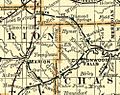
1893 Railroad Map
-
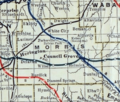
1915 Railroad Map of Morris County


