Cíes Islands facts for kids
|
Native name:
Illas Cíes
|
|
|---|---|

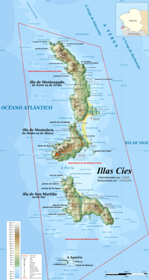
Location and topographic map of the Cíes Islands
|
|
| Geography | |
| Coordinates | 42°13′24″N 8°54′14″W / 42.223333°N 8.903889°W |
| Total islands | 3 |
| Major islands | Monteagudo, Do Faro, San Martiño |
| Highest elevation | 197 m (646 ft) |
| Administration | |
|
Spain
|
|
| Autonomous Community | Galicia |
| Province | Pontevedra |
| Municipality | Vigo |
| Demographics | |
| Population | 3 |
The Cíes Islands (Galician: Illas Cíes; Spanish: Islas Cíes) are a group of islands found off the coast of Galicia, Spain. They are located near the city of Pontevedra, right at the entrance of the Ria de Vigo (a type of bay). These beautiful islands became a special Nature Reserve in 1980. Later, in 2002, they became part of the Atlantic Islands of Galicia National Park. This means they are very important for nature and are protected.
Contents
Exploring the Cíes Islands
The Cíes Islands are made up of three main islands. These are Monteagudo (also called the North Island), do Faro (the Middle Island or "Lighthouse Island"), and San Martiño (the South Island).
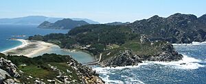
Monteagudo is separated from the mainland by a channel called the North Canal. San Martiño is separated from the coast by a narrow Strait called Freu da Porta. The island of Do Faro is connected to Monteagudo by a long sandy beach. This beach is called Rodas beach and is about 1,200 meters (0.75 miles) long.
When the tide is high, the sea flows between the islands on the western side. It then gets blocked by the beach, filling a lagoon between the sand and the rocks. The highest point on the islands is Alto das Cíes, which is 197 meters (646 feet) tall. It is located on Monteagudo.
How the Islands Formed
The Cíes Islands formed a very long time ago, at the end of the Tertiary period. This happened when parts of the coast sank, creating the unique "rías" (estuaries or bays) of Galicia. All three islands are actually the tops of coastal mountains that are now partly underwater. They are mostly made of granitic rock.
The islands have a mountainous landscape. On the western side, there are rough, almost vertical cliffs that are over 100 meters (328 feet) high. You can also find many caves here, formed by the sea and wind. The eastern side is not as steep. It has woods and bushes and is protected from the strong Atlantic winds. This protection allows beautiful beaches and dunes to form.
The islands get a lot of rain from Atlantic storms. These storms hit the coast and drop their rain. However, the Cíes Islands receive about half the rain compared to other areas in the Rías Baixas region.
A Special Nature Reserve
The Cíes Islands are very important for nature. Because of their natural beauty and the damage they were facing from human activities, they were made a Nature Reserve in 1980. Their legal protection grew over time. In 2000, the Galician Parliament asked for them to become a National Park.
In June 2002, the Spanish government officially created the National Land-Marine Park of the Atlantic Islands of Galicia. This park includes several island groups, not just the Cíes. Other islands in the park are Ons, Sálvora, Noro, Vionta, Cortegada Island, and the Malveiras Islands.
The marine part of the park extends 100 meters (328 feet) from the shore at low tide. To protect the sea life, underwater fishing has been forbidden around the islands since 1992. National Parks are areas that are almost untouched by humans. They are protected because of their amazing landscape, geological features, or ecosystems. They have important aesthetic, ecologic, educative, or scientific value.
This means that activities that could harm the ecosystem are not allowed. However, some traditional activities, like certain types of fishing, are permitted if they don't harm the environment or natural resources.
Since 1988, the islands have also been a ZEPA (Zona de Especial Protección para las Aves), which means a Special Protection Area for Birds. They are part of the Natura 2000 network, which helps protect important habitats and birds in Europe. The Cíes Islands are home to one of the largest colonies of yellow-legged gulls. ZEPAs are protected to prevent pollution and damage to places where birds live permanently or rest during their migrations.
Visiting the Islands
During the summer, you can take boats to Monteagudo from the ports of Vigo, Baiona, and Cangas. If you want to stay overnight, there is a camping area. You need to book your spot at the Vigo port beforehand.
For visitors, there is a supermarket, a visitor center, and a restaurant. It's important to know that there are no waste bins on the islands. Visitors must take all their litter back to the mainland to help keep the islands clean.
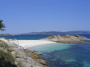
The Cíes Islands have nine beautiful beaches with soft white sand and clear waters. In 2007, a British newspaper called The Guardian named Rodas beach, on Monteagudo island, "the best beach in the world." They described it as "a perfect crescent of soft, pale sand backed by small dunes sheltering a calm lagoon of crystal-clear sea." In 2022, The New York Times also featured the islands as one of its "52 Places for a Changed World." This was because of their efforts to protect the environment and manage tourism carefully.
Plants of the Cíes Islands (Flora)
The scrubland on the islands is mostly made up of native plants. These include gorse, broom, asparagus, spurge flax (Thymelaea), and rockrose (Cistaceae).
The woodland has changed more over time. Many native trees, like the common fig and the Pyrenean oak, are now rare. This is because about a quarter of the island's surface has been replanted with pine trees and eucalyptus. Also, strong, salty winds make it hard for trees to grow tall.
Some rare and special coastal plants grow in the dunes, on the beaches, and on the cliffs. These plants can survive in very harsh weather. Examples include the sea pink (Armeria pungens), which is locally endangered. There are also many camariñas (Corema album), a plant found only on the western coast of the Iberian Peninsula. Plants that like marshlands, like rushes, grow in the lagoon area.
Animals of the Cíes Islands (Fauna)
The Cíes Islands are home to a very large colony of seagulls, with about 22,000 pairs. They are the most common bird species here. In 1960, there were 400 pairs of Iberian guillemots (a type of bird), but now they are almost gone from the islands.
Other birds you might see include birds of prey, pigeons, petrels, pelicans, doves, and woodpeckers. These birds build their nests in the trees and on the cliffs. Many birds also spend the winter here or stop to rest during their migratory journeys. You can find bird-watching spots at Alto da Campa (on Illa do Faro) and Faro do Peito (on San Martiño).
The waters around the islands are full of different kinds of sea life. This attracts larger animals like whales, dolphins, and sharks, including blue sharks and basking sharks.
Underwater World and Seabed
The area underwater around the Cíes Islands is one of the richest ecosystems on the Galician coast. One of the most amazing things you'll find is a large "forest" of brown algae.
Different parts of the islands' coast have different underwater environments:
- Cliffs: These areas are hit by strong waves. Here, you can find barnacles and mussels. Underwater, in the rocky parts, you might see crabs, spider crabs, lobsters, and octopuses.
- Beaches: In the more protected beach areas, there are many bivalve molluscs (like clams and oysters). You can also find fish like turbot, plaice, and sole.
- Protected Rocky Areas: The rocky areas inside the islands that are protected from strong waves are home to real "forests" of anemones and many sea urchins.
Dolphins, whales, and sea turtles often visit the waters around the Cíes. The way the water moves in and out of the Galician estuaries, along with the mix of fresh and salt water, helps create a lot of nutrients and tiny organisms. These are a great food source for all the other marine species.
You can also find old archaeological remains on these seabeds, showing a long history.
See also
 In Spanish: Islas Cíes para niños
 | Leon Lynch |
 | Milton P. Webster |
 | Ferdinand Smith |


