Casiri (Tacna) facts for kids
Quick facts for kids Casiri |
|
|---|---|
| Paucarani, Paugarani | |
 |
|
| Highest point | |
| Elevation | 5,650 m (18,540 ft) |
| Geography | |
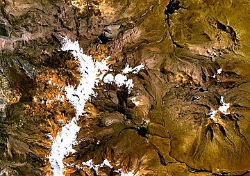
Casiri, also known as Paucarani, is a tall volcano in the Andes mountains of Peru. It stands about 5,650 meters (18,537 feet) high. Casiri is located in the Tacna Region.
This volcano is actually made up of four separate volcanic parts. It has lava domes, which are like sticky piles of lava. The part in the southeast has been active in recent geological times. It created thick lava flows that covered older rock formations. The newest lava flow happened about 2,600 years ago.
Even though we don't know of any eruptions in recorded history, scientists think Casiri could still be active. They watch it closely. The volcano also has hot spots and is part of a bigger area that could produce geothermal power. There are two sulfur mines on the volcano. The Paucarani reservoir, which holds most of Tacna's water, is also connected to Casiri. The Rio Uchusuma river, which flows into the reservoir, starts on the volcano.
Contents
What's in a Name?
The name "Casiri" might mean "bawler" in the Aymara language. Casiri is also called Paucarani or Paugarani. Sometimes, people think Casiri and Paucarani are different volcanoes.
About 5 kilometers (3 miles) north of the volcano is a lake also named "Casiri." This lake is a glacial lake, formed by a glacier. It is also a reservoir that flows into the Mauri River.
Where is Casiri Located?
Casiri is a stratovolcano that is 5,650 meters (18,537 feet) tall. It is very close to the border between Peru and Chile.
There are four main parts to the Casiri volcano. Three older parts form a long chain about 5 kilometers (3 miles) long. The fourth part is newer and sits to the southeast. This newer part has a well-preserved lava dome inside its crater. An older lava dome is found in the western part of the volcano.
Casiri grew on the side of older volcanoes. It rises about 1,050 meters (3,445 feet) above the land around it. The whole volcano is about 5 kilometers (3 miles) wide.
How Does Lava Flow?
Thick, sticky lava flows come from the newer part of the volcano. They spread out in different directions. These lava flows can be up to 2 kilometers (1.2 miles) long. They look dark in satellite images. Some parts of the volcano have changed due to hot water and gases. This makes the rocks look gray-white and clay-like. Wind also blows ash over some of the lava flows.
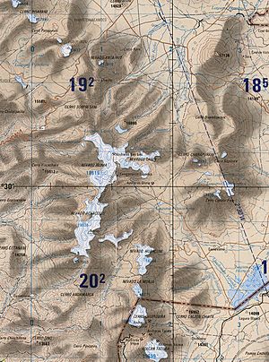
Casiri is part of the Cordillera del Barroso mountain range. The land around Casiri has many volcanic features. It also has formations made by glaciers and rivers. The nearby mountains, Auquitapie and Iñuma, are covered with snow. Casiri is considered part of the "Paucarani Volcanics" in terms of its geology.
Water Around Casiri
The Rio Uchusuma river starts on Casiri. This river is a branch of the Rio Mauri. There is a natural lake called Paucarani at the southeastern base of Casiri. The Quebrada Achuco valley is also south of Casiri and has wetlands. To the north and northeast is the Quebrada Mamuta, which flows southeast. To the northwest, streams flow through Lake Casiri and Lake Liñuma into the Rio Mauri. Volcanic activity has changed how water flows in the area. It has created lava dams, which can change river paths.
Paucarani Reservoir
A large earth dam was built on the Rio Uchusuma between 1982 and 1986. This dam created a reservoir also called Paucarani. It is located at the southeastern foot of the volcano. This reservoir is very important for the water supply of Tacna. It can hold about 10.5 million cubic meters (370 million cubic feet) of water. Water from the Paucarani reservoir is sent to Tacna through the Canal Uchusuma. This water covers 90% of Tacna's water needs for both irrigation (watering crops) and drinking.
The Paucarani reservoir also helps control the Rio Caplina. In 2012, a broken floodgate caused a damaging flood. Changes to the reservoir to hold more water might be causing water leaks in the dam. There have also been reports of the water being polluted with unwanted substances.
People and Places
Casiri is in the Tarata Province of the Tacna Region in Peru. It is about 100 kilometers (62 miles) northeast of the city of Tacna. It is also close to the borders with Chile and Bolivia.
The volcano is north of the town of Paucarani. Other places nearby are Calachata and Tulipiña. There are many roads in the area. One road runs south of the volcano. The town of Paucarani can be reached from a highway that connects Tacna with Charaña in Bolivia and Villa Industrial in Chile. The area around Casiri does not have many people living there.
Casiri is seen as a good place for tourists because of its beautiful scenery. It is also part of the Monumento Natural de Paucarani geopark. There have been ideas to make it a protected area. The Paucarani reservoir could also be used for tourism.
How Casiri Formed
The Nazca Plate is slowly sliding under the South America Plate. This movement causes volcanoes to form along the western coast of South America. This area has three main volcanic belts. Casiri is part of the Central Volcanic Zone. Peru has over 300 volcanoes. Some of them, like El Misti and Ubinas, have erupted in recorded history. Peru also has hot springs and geysers. Even with all this activity, we don't know much about Peru's volcanoes.
What is Casiri Made Of?
The rocks that Casiri has erupted tell us what it is made of. It is mostly made of andesite, basaltic andesite, and trachyandesite. These rocks have a special texture called porphyric. They contain crystals of minerals like biotite and plagioclase. Gases from the volcano have also left behind sulfur deposits.
When Did Casiri Erupt?
Casiri is one of the youngest volcanoes in southern Peru. It has been active since the last ice age. Lava flows from the Holocene period (the last 11,700 years) cover older glacier deposits. Scientists have used special dating methods. They found that some dark lava flows are about 6,000 years old and 2,600 years old.
There are no known eruptions in recorded history. However, there are hot springs and gas vents (called solfataras) that are likely powered by the volcano's magma. Casiri is considered a "potentially active" volcano. This means it could erupt in the future. Earthquakes in 2020 and 2021 in the area do not seem to be related to the volcano.
In 2012, the Geophysical Institute in Peru started monitoring Casiri. They use seismometers to detect earthquakes. They consider it a "low hazard" volcano. As of 2021, there are two seismometers and one instrument measuring how the volcano changes shape. More instruments are planned to be installed in 2022.
How People Use Casiri
Mining for Sulfur
The Gloria sulfur mine is located on Casiri. It is found at the base of Paucarani, southeast of the lava flows. The sulfur is in rocks that have been changed by volcanic activity. This area covers about 1 square kilometer (0.4 square miles). People have dug trenches and wells to get the sulfur. Another mine, San Luis, might also be connected to Paucarani. It is on the northwestern side of the volcano. Some valuable metals might also be found in these areas.
Geothermal Power
The area around Casiri has a geothermal field called Chungará-Kallapuma. There are about 50 hot vents along the Quebrada Chungará and Kallapuma River. These vents can reach temperatures of 83.4 degrees Celsius (182 degrees Fahrenheit). These hot spots are linked to the nearby volcanoes. The volcanoes provide the heat, and rainwater supplies the water. Cracks in the ground (faults) allow the hot water to rise. Local people use these hot springs as spas.
Scientists have studied the potential for geothermal power in the Tacna Region. Tacna gets its electricity from oil (which is not renewable) or from hydropower (which depends on rain). Mining is a big part of Tacna's economy and uses a lot of electricity. The Chungará-Kallapuma geothermal field could produce enough power for a 75 megawatt power plant. Even though there has been research since 1974, Peru has not yet produced geothermal power as of 2013.
See also
 In Spanish: Casiri (Tacna) para niños
 | Isaac Myers |
 | D. Hamilton Jackson |
 | A. Philip Randolph |


