
Central Waterfront, Seattle facts for kids
Quick facts for kids
Central Waterfront, Seattle
dᶻidᶻəlal̕ič
|
|
|---|---|
|
Seattle Neighborhood
|
|

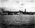
Southeast view of the Central Waterfront from the Bell Street Terminal in 2006.
|
|

Unofficial boundary map of the Central Waterfront
|
|
| Country | United States |
| State | Washington |
| County | King |
| City | Seattle |
| Zip Code |
98101
|
| Area Code | 206 |
The Central Waterfront in Seattle, Washington, is a lively part of the Elliott Bay shoreline. It stretches from the Pioneer Square area northwest through Downtown Seattle and Belltown. It ends near the Olympic Sculpture Park.
This area was once a very busy place for ships and boats. In the 1960s, a large container port was built to the south. Since then, the Central Waterfront has become a fun place for recreation and shopping. Many old piers now have shops and restaurants. You can also find parks, a Ferris wheel, the Seattle Aquarium, and even a hotel built over the water.
Some docks are still used by the Port of Seattle. These include a cruise ship dock, ferry terminals, and a fireboat dock. You can see many old buildings that show the area's history as a port. A few businesses from that time are still open today.
Contents
Exploring Seattle's Central Waterfront
Like many neighborhoods in Seattle, the Central Waterfront doesn't have exact, agreed-upon borders. The Seattle Waterfront Plan says it runs from Jackson Street in Pioneer Square north along the Elliott Bay shore. It goes through Downtown to Broad Street, near the north end of Belltown.
To the south, you'll find the Port of Seattle's container port. To the north is the Olympic Sculpture Park. The plan doesn't say how far inland this "waterfront" area goes.

A study from 2006 by the Department of Neighborhoods agrees on the northern end. But it places the southern border at Columbia Street. This is a block north of Yesler Way at the water's edge. This means it doesn't include the Pioneer Square neighborhood.
In its southern part, the waterfront is separated from inland Seattle by the Alaskan Way Viaduct. This raised highway continues north through downtown. As you go further north, the land rises quickly from the water. This creates a clearer difference between the waterfront and the higher areas.
There are several ways to get between the Central Waterfront and the higher parts of the city. The Harbor Steps at University Street lead to the Seattle Art Museum. The Pike Hill Climb goes from the Seattle Aquarium up to the Pike Place Market. Further north, there are the Lenora Street and Bell Street Bridges.
Historically, Seattle's Central Waterfront went further south and had a similar feel. But since the mid-1960s, the area to the south has become a container port. Seattle's current pier numbering system started during World War II.
Main Roads Along the Waterfront

As of 2008, the two main roads along the Central Waterfront were Alaskan Way and the Alaskan Way Viaduct. The viaduct ran from Battery Street south. Alaskan Way follows the path of an older railway line and a road once called Railroad Avenue. This route goes from just north of S. Holgate Street in the Industrial District to Broad Street.
The original Railroad Avenue was a planked road built on pilings over Elliott Bay. It was very busy with horses, buggies, people, and trains. Things got a bit better when the Great Northern built a rail tunnel (1903–1906) under Downtown. This meant trains that didn't need to stop at the waterfront could avoid the busy road.
However, the planked road still had problems. Between 1911 and 1916, a concrete seawall was built to strengthen the waterfront. By 1936, the seawall reached Bay Street, its current length. Railroad Avenue officially became Alaskan Way. But it wasn't properly paved until 1940. In the early 1950s, the Alaskan Way Viaduct was built, running next to Alaskan Way.
From 1982 to 2005, the George Benson Waterfront Streetcar Line ran parallel to Alaskan Way. The trolley barn was torn down to build the Olympic Sculpture Park. Since 2005, buses have served a similar route.
Piers and Buildings of the Waterfront
The piers of Seattle's Central Waterfront are numbered from Pier 46 at the south end to Pier 70 at the north end.
Piers 46–48: Southern End
Pier 46 is the southernmost pier on the Central Waterfront. It's also the northernmost pier of the Port of Seattle's container port. For a couple of years in the early 2000s, part of it was used as a homeless shelter. There's been a lot of talk about what Pier 46 will be used for in the future. Ideas include a sports arena, housing, shops, or staying as part of the port.

Pier 48, at the foot of Main Street, also includes the old Pier 47. Famous bands like Nirvana played a concert here in 1993. Until 1999, this pier was where a ferry service to Victoria, British Columbia operated. After the ferry left, Pier 48 became home to a museum ship, the Soviet submarine Cobra. The Washington State Department of Transportation (WSDOT) bought the pier in 2008. They tore down the large warehouse in 2010 to use the space for the demolition of the nearby Alaskan Way Viaduct.
Piers 46–48 are in the area where Ballast Island used to be. Pier 48 started in 1901 as part of the Pacific Coast Company's Ocean Dock. In the early 1900s, there was a train terminal here for the Columbia and Puget Sound Railroad.
Harbor Entrance Pergola

There is no Pier 49 today. This spot used to be the Washington Street Boat Landing, but it's now closed. The most important feature left here is the Harbor Entrance Pergola. It's listed on the National Register of Historic Places. It was originally a place for boats to drop off passengers from ships.
Over the years, different ideas have been suggested for this site. These include a terminal for the King County Water Taxi to West Seattle or a place to dock the historic tugboat Arthur Foss. In 2010, a water taxi crashed into the pier, injuring several people. As of 2013, the site is used for maintaining the King County Metro water taxi.
The Harbor Entrance Pergola was one of the last historic structures built for Seattle's Pioneer Square district. It's the only important landmark on the west side of Alaskan Way. It was designed by Seattle City Architect Daniel Riggs Huntington and built in 1920. The pergola was fixed up in the 1970s.
Washington State Ferry Terminal

Pier 50 and Pier 52 are busy ferry terminals for Washington State Ferries and the King County Water Taxi. There is no longer a Pier 51. Pier 50 has two passenger-only water taxis going to Vashon Island and West Seattle. Ferries that carry both cars and people leave from Pier 52 for Bainbridge Island and Bremerton.
Pier 52 was historically known as Colman Dock. The first Colman Dock was built in 1882. It burned down in the Great Seattle Fire of 1889 but was quickly rebuilt. In 1908, the dock was made longer and a domed waiting room and a clocktower were added.
In 1912, a ship called Alameda accidentally crashed into the dock. The dock tower fell into the bay, and a boat sank. The clock was saved, and the dock was rebuilt with a new tower. Later that year, a gangplank collapsed, and people fell into the water. Two people died.

In 1912, Puget Sound was served by many different boats called the "Mosquito Fleet". The next year, Joshua Green started the Puget Sound Navigation Company (PSNC). They soon controlled most of the regional ferries. In the mid-1930s, they updated Colman Dock in an Art Deco style.
In 1951, Washington State bought PSNC and took over the ferry system. Work on the current terminal began ten years later. There have been many changes and updates since then. The very month the state ferry terminal opened, another accident happened. The ferry MV Kalakala crashed into the terminal in 1966. The damage wasn't too bad, and the ferry was back in service the next day.
The clock from the old Colman Dock tower, which fell into the bay in the 1912 accident, was found in pieces in 1976. It was restored and put back on the current Colman Dock in 1985.
The Grand Trunk Pacific dock was just north of Colman Dock. The original dock was built in 1910 as the largest wooden pier on the West Coast. But on July 30, 1914, it was destroyed by a huge explosion and fire. Five people died. A new dock was built quickly and lasted until 1964.
Fire Station No. 5

Pier 53 is a very short pier just north of the ferry terminal. It's the home of Seattle Fire Station No. 5. The current building, built in 1963, is the third fire station at this address. The fire department was very important on the waterfront because the piers and even the road were made of wood. The Great Seattle Fire of 1889 destroyed many piers.
After the Great Fire, a small wooden firehouse was built nearby in 1891. It had a crew of nine and the new fireboat Snoqualmie. In 1902, a larger two-story wooden building was built on the current site. In 1910, the new fireboat Duwamish replaced the Snoqualmie. The wooden building was torn down in 1916 and replaced by a beautiful brick building in 1917. Another fireboat, Alki, started service in 1928.
By the early 1960s, the wooden supports of the 1917 fire station were becoming unsafe. The building was torn down in 1961. After a lot of work on the pier supports, the new modern building opened in December 1963.
Piers 54–56: Shops and Cruises

Pier 54 (originally Pier 3) was built in 1900 by the Northern Pacific Railway. Its first tenants were grain and building material dealers. In the "Mosquito Fleet" days, it was known as the Galbraith Dock. From 1929 to the mid-1930s, it was the main office for Gorst Air Transport, which ran a seaplane service. By 1944, the Washington Fish and Oyster Company (now Ocean Beauty Seafoods) owned the pier.
In 1938, Ivar Haglund rented a small part of the pier for a one-room aquarium and a fish and chips stand. The aquarium closed around 1945, and the restaurant moved and was redesigned. Ivar's Acres of Clams became the main restaurant of the Ivar's seafood chain. In 1966, Haglund bought the pier.
Since 1988, Pier 54 has been home to Ivar's Acres of Clams and Ye Olde Curiosity Shop. This shop has been on the Central Waterfront since 1899. Besides souvenirs, it sells Northwest Native art and other unique items. The store also has a "museum" with strange things like "Sylvester" the mummy and shrunken human heads.

Pier 55, at the foot of Spring Street, was originally Pier 4. The first Pier 4, built in 1900, collapsed in 1901. No one was killed, and the Northern Pacific Railroad built a new Pier 4 the next year, which is now Pier 55. Its first tenant, the Arlington Dock Company, was a shipping agent for passenger steamships. The pier was used for passenger service until around World War I. The Fisheries Supply Company was the main tenant for many years. The pier was remodeled in 1945 and again in the late 1990s.
The north side of Pier 55 used to be the downtown stop for the Elliott Bay Water Taxi to West Seattle. Now, it's at Pier 50. Between Piers 55 and 56, Argosy Cruises docks its tour boats.
Pier 56 (originally Pier 5) was built in 1900. President Theodore Roosevelt landed here in 1903. It was the base for Frank Waterhouse and Company, a steamship line important during the Klondike Gold Rush. They transported people to the Yukon and Alaska.
After the Waterhouse company, the pier housed other firms. During the 1962 Century 21 Exposition (the World's Fair), the pier added shops, restaurants, and fish houses. It stopped being a transportation hub. Ted Griffin's Seattle Marine Aquarium was located here. Its star attraction, Namu the killer whale, died in 1966.
Piers 57–63: Recreation and Aquarium

The city bought Pier 57 in 1971 and Piers 58 to 61 in 1978. This happened after cargo shipping moved to the container port. In 1989, the city traded Pier 57 for Piers 62 and 63.
Pier 57 (originally Pier 6) was built in 1902. It was originally for the John B. Agen Company. In 1909, the pier went to the Chicago, Milwaukee & St. Paul Railroad, so it became known as the "Milwaukee Pier." It became a terminal for several steamship lines. In the 1950s, part of the pier was used for fish processing. By the 1960s, the Port of Seattle owned the pier and added holes for fishing.
In 1971, the City bought the pier and renovated it. The renovated pier, now called the "Bay Pavilion," has restaurants, shops, an arcade, and an old carousel. In June 2012, a 175-foot Ferris wheel, the Seattle Great Wheel, opened here. Pier 57 is now privately owned.
Pier 58 (originally Pier 7) was built around the same time Pier 57 was renovated. Waterfront Park was built where the Schwabacher Wharf used to be. The Schwabacher Wharf survived the Great Seattle Fire in 1889. In the 1890s, two important events happened here. The ship Miike Maru started Seattle's trade with Japan in 1896. Less than a year later, in 1897, the steamship Portland arrived from Alaska with a "ton of gold" from the Klondike, Yukon. This started the Yukon Gold Rush, which brought a lot of wealth to Seattle.

Pier 59 is where the main building of the Seattle Aquarium is located. It was built on a pier shed from 1905. In 1896, fish and grain dealers Ainsworth and Dunn built a pier here, originally Pier 8. It was also known as the Pike Street Pier. Later, it became known as the Dodwell Dock. In the 1950s and early 60s, Pier 59 was home to Puget Sound Tug & Barge.
The two "stubby" piers known as the Fish and Salt Docks (later Piers 60 and 61) were removed in 1975 to make space for the Seattle Aquarium.
Pier 62 (built in 1901) and Pier 63 (built in 1905) no longer have their original sheds. Pier 62 was originally Pier 9, known as the Gaffney Dock. Pier 63 (originally Pier 10) was known as the Holden Dock or Virginia Street Dock. One of its main tenants was Northwest Fisheries, which canned Alaskan red salmon. For many years, these piers hosted the Summer Nights at the Pier concert series. However, the piers became too old and weak for large crowds. In 2017, work began to replace the wooden supports with steel legs and add a floating dock.
Bell Street Pier, Edgewater Hotel, and Port Headquarters
Pier 66 is the official name for the Port of Seattle's Bell Street Pier and Bell Harbor complex. This replaced the older Piers 64, 65, and 66 in the mid-1990s. The Bell Street facility has a marina, a cruise ship terminal, a conference center, restaurants, and marine services. A pedestrian elevator and overpass connect it to the World Trade Center and Belltown. This area used to be a shantytown.
Pier 67, once called Galbraith-Bacon Pier, is where The Edgewater hotel is located. The hotel has hosted many famous people, including the Beatles in 1964 during the height of Beatlemania. Pier 68 was torn down when the hotel was built on the newly rebuilt Pier 67.
Pier 69 is north of Pier 67. It's the site of the Port of Seattle headquarters. It's also the Seattle terminal for Clipper Navigation, a passenger-only ferry service to Victoria, British Columbia and Friday Harbor, Washington. This pier has been heavily remodeled, but its history goes back to Pier 13, built in 1900.
Pier 70: Northern End

Pier 70, at the foot of Clay and Broad Streets, marks the northern end of the Central Waterfront. Beyond it are the Olympic Sculpture Park and Myrtle Edwards Park. Although the pier building still looks historic from the outside, it was heavily changed after a fire in 1915 and again in the 1970s and 1990s.
The pier was built as Pier 14 in 1902 by Ainsworth and Dunn. They also built a warehouse across Railroad Avenue (now Alaskan Way). This warehouse later became the Old Spaghetti Factory restaurant. Ainsworth and Dunn's Seattle Fish Company started in 1889. They owned Pier 14 until at least 1920, renting it to different companies.
Like the piers to its south, its old uses for shipping changed because of containerization. It was remodeled to have shops and restaurants. In the late 1990s, it was remodeled to be the headquarters for a tech company. In 1998, the TV show The Real World: Seattle was filmed there.
Buildings Across Alaskan Way

Several buildings on the inland side of Alaskan Way have strong ties to the waterfront's past. For example, the building that now houses the Old Spaghetti Factory was built with Pier 14 (now Pier 70). Southeast from there, the building that is now the headquarters of Zulily was built in 1916 as the American Can Company. It had a bridge connecting it to Pier 69 in the 1930s.
Another example is the Agen Warehouse, also known as Olympic Cold Storage Warehouse. It's at the corner of Western Avenue and Seneca Street. Designed by architect John Graham and built in 1910, it's listed on the National Register of Historic Places. It originally housed John Agen's Alaska Butter and Cream Company.
History of the Central Waterfront
Early Native Villages

People lived on what is now Seattle's Central Waterfront long before the city was founded. The Duwamish had a winter village of about eight longhouses near what is now First Avenue South and Yesler Way. With about 200 people, it was one of the largest villages along Elliott Bay. Its name, Djicjila'letc, means "little crossing-over place."
Further north, near Bell Street, was another Duwamish camp called Ba'qbaqwab ("little prairies"). By the 1860s, the longhouses were gone, but small beach structures remained. There were also burial grounds near Seneca Street.
Chief Seattle's daughter, Princess Angeline, lived on the central waterfront until she died in 1896. We don't know exactly where her beach shack was, but photos show it was just north of the current Pike Hill Climb. Into the 1890s, the Duwamish also camped on Ballast Island. This island was made from material dumped by ships. Later, Ballast Island was covered with planks and then dredged to become part of the harbor.
19th Century Development
Henry Yesler started his steam-powered sawmill in October 1852. This mill and its wharf were the most important structures on the waterfront for many decades. The wharf became a central place for transportation.
;_398,_296382125102001_602.jpg)
The Seattle, Lake Shore and Eastern Railway (SLS&ER) was the first to build a train line along the water in 1887. The SLS&ER was later bought by the Northern Pacific Railway. James J. Hill's Great Northern Railway built tracks even closer to the water. Railroad Avenue, where both railways ran, was 120 feet (37 m) wide and built mostly on pilings over the tideflats.
The Great Seattle Fire (June 6, 1889) destroyed Yesler's Wharf and all other waterfront buildings south of Union Street. The only major wharf left after the fire was the Schwabacher Dock, just north of the burned area. Within four years, there was huge redevelopment. An 1893 map shows West Street (now Western Avenue) running the entire length of the Central Waterfront. There were many docks, mostly at right angles to the shore. The map shows that fishing was not yet a big industry. More common uses were warehouses for grain.
Before Washington became a state in 1889, it wasn't clear who owned the tidelands. Yesler and others built on the tidelands anyway. The new state constitution said the state owned the tidelands but allowed exceptions. It also set aside areas along the shore for "landings, wharves and streets." This was later changed to give cities more control over their shorelines.
The design of the "finger" piers on the Central Waterfront, which are mostly parallelogram-shaped, comes from an 1897 plan. Their uniform northeast-southwest direction was set by city engineer Reginald H. Thomson. This design helped freight trains and prevented piers from crashing into each other where the shoreline curved.
Heyday, Stagnation, and Revival

For the first half of the 20th century, Seattle's Central Waterfront was a very busy center for one of North America's major ports. The needs of the waterfront created an area with light industrial businesses and hotels for workers. The waterfront was a place where different groups had different goals. These included big businesses, labor unions, and reformers.
The reformers achieved a big goal when the Port of Seattle was created in 1911. It was the first municipal corporation (a public business owned by the city) in the United States. It had elected port commissioners. Even with this, much of the Central Waterfront remained privately owned for many decades.
The Port Commission had a huge impact soon after it started. Their first Bell Street Pier (1914) created a strong presence on the waterfront. Seattle became a very successful port during World War I. Seattle did well as a port in the 1920s, especially with more trade with Japan. They imported things like soybean oil and raw silk.

Shipping lines with facilities on Central Waterfront piers in the 1920s included local steamer companies and large international lines.
Even though Seattle was hit hard by the Great Depression, development on the Central Waterfront didn't stop completely. Old stables became garages, the Black Ball Line updated Colman Dock in an Art Deco style, and Gorst Air Transport operated seaplanes. The American Can Company built its large building across from Pier 69, and the seawall was greatly extended in 1934.
During World War II, 29 shipyards operated in Seattle, though none were on the Central Waterfront. This period also saw the introduction of fork lifts and pallets to move cargo. These changes made the old piers less useful. In 1946, the president of the Port Commission suggested tearing down the old piers. He proposed "modern reinforced concrete structures" suitable for "large ocean-going vessels." These plans were not adopted.
In the 1950s, Seattle was a port in decline. The Port of Seattle owned most of the over-water structures on the Central Waterfront. But most shipping traffic used other piers. Also, the construction of the Alaskan Way Viaduct in the early 1950s created a barrier between much of the Central Waterfront and Downtown.

With maritime activity moving elsewhere, people started to think about the Central Waterfront as a tourist spot. In 1960, the only tourist businesses on the piers were Ye Olde Curiosity Shop (founded in 1899) and Ivar Haglund's Acre of Clams restaurant (founded in 1938). Most plans from this time suggested tearing down almost all the historic piers. (There were also plans to tear down many buildings in Pioneer Square at this time.)
Ideas for new uses included a sea circus, an aquarium, hotels, a park, a marina, and shops. One hotel, now The Edgewater, was built in 1962–63. There was already criticism of the Alaskan Way Viaduct, with one architect calling it a "major built-in problem."
Signs of revival began in the 1960s and sped up in the 1970s and '80s. Several piers were updated to have shops and restaurants. Ted Griffin's Seattle Marine Aquarium was on Pier 56 from 1962 to 1976. It was followed by the current Seattle Aquarium on Pier 59. All of these changes kept the historic pier structures. The area once used by the Schwabacher Wharf became Waterfront Park. Many historic buildings on land nearby were also fixed up.
Future of the Waterfront

The city has an official Waterfront Concept Plan. This plan started in 2003 with a large meeting in 2004. Plans are also being considered for major work at the Washington State Ferry terminal and the Seattle Aquarium. The Olympic Sculpture Park has already changed the northern end of the Central Waterfront.
Some things about the future of the Central Waterfront are clear. The 2001 Nisqually earthquake showed that the Alaskan Way Viaduct is not safe, and the seawall is in very bad condition. Another earthquake could cause the ground to become liquid, damaging the viaduct and putting huge pressure on the seawall. So, things cannot stay as they are. The old Piers 62 and 63 also need to be replaced.
In 2008, the Washington State Department of Transportation looked at eight ways to replace the viaduct. These included surface roads, new viaducts, and tunnels. The bored tunnel option was chosen the next year. The city's Department of Parks and Recreation is also looking at five different ways to replace Piers 62 and 63.
The State Route 99 tunnel opened in February 2019. The Alaska Way Viaduct was torn down during 2019. This allows for new development of the waterfront area. Plans for the future waterfront, with construction into 2023, include a new Alaskan Way with bike lanes, a landscaped walkway, and paths connecting the waterfront to Pike Place Market.
Images for kids
-

In 1900 the Lilly Bogardus warehouse stood on Oregon Improvement Company Pier B near the site of today's Pier 48.
-

Harbor Steps, 2016
-

Colman Dock in 1912, surrounded by "Mosquito Fleet" boats.
-
The pre-fire Grand Trunk Pacific dock, Colman Dock, and Alaska Steamship Co. at Pier 2, which later became Pier 51.
-

Grand Trunk Pacific Dock (at left) shortly before its 1964 demolition.
-

A BNSF freight train passing by the former American Can Company building.
-

Yesler, Crawford and other wharves in 1882.


.jpeg)


