Chesapeake Bay Interpretive Buoy System facts for kids
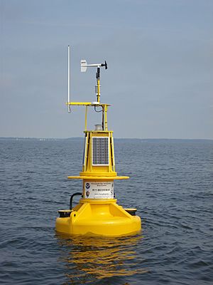
The Chesapeake Bay Interpretive Buoy System (CBIBS) is a cool network of special buoys. These "smart buoys" float in the Chesapeake Bay. They help us understand what's happening in the Bay. They also act like helpful markers along the Captain John Smith Chesapeake National Historic Trail.
The United States National Oceanic and Atmospheric Administration (NOAA) takes care of these buoys. They collect important information about the weather, ocean, and water quality. You can get this information right away! Just call 1-877-BUOY-BAY or visit http://buoybay.noaa.gov/. CBIBS helps track how the Bay is getting healthier.
Contents
Where are the Smart Buoys Located?
There are ten main buoys in the CBIBS system. They are placed in important spots around the Chesapeake Bay. Each buoy helps us learn about a different part of the Bay.
Here are some of their locations:
- Near the start of the Susquehanna River (close to Havre de Grace, Maryland) 39°32.541′N 76°04.495′W / 39.542350°N 76.074917°W
- At the mouth of the Patapsco River (near Baltimore) 39°09′07″N 76°23′28″W / 39.15191°N 76.39115°W
- Near the Severn River (close to Annapolis, Maryland) 38°57′47″N 76°26′51″W / 38.9631°N 76.4475°W
- In the upper Potomac River (south of the Woodrow Wilson Bridge, near Alexandria, Virginia) 38°47′15.6″N 77°02′08.34″W / 38.787667°N 77.0356500°W
- Off the Little Choptank River 38°33.375′N 76°24.882′W / 38.556250°N 76.414700°W
- At the mouth of the Potomac River (near Point Lookout, Maryland) 38°01′59″N 76°20′08″W / 38.033°N 76.3355°W
- Near the Rappahannock River (close to Stingray Point and Deltaville, Virginia) 37°33′06″N 76°15′05″W / 37.5517°N 76.2514°W
- In the James River (near Charles City, Virginia) 37°18′50″N 77°11′28″W / 37.3138°N 77.191°W
- Also in the James River (near Jamestown, Virginia) 37°12′15″N 76°46′39″W / 37.20417°N 76.7775°W
- In the Elizabeth River (near Norfolk, Virginia) 36°50′44″N 76°17′53″W / 36.8455°N 76.298°W
- At the very mouth of the Chesapeake Bay (near Cape Henry, Virginia) 36°58′45″N 76°02′37″W / 36.9793°N 76.0436°W
What Kind of Data Do the Buoys Collect?
These smart buoys gather lots of different real-time information. This means you can get the data as it happens! They record details about the weather, the ocean, and the water quality.
Here are some examples of the data they collect:
- Air temperature: How warm or cold the air is.
- Relative humidity: How much moisture is in the air.
- Barometric pressure: The air pressure, which helps predict weather.
- Wind speed and direction: How fast the wind is blowing and where it's coming from.
- Wave height and direction: How big the waves are and which way they are moving.
- Currents: The movement of the water.
- Water temperature: How warm or cold the water is.
- Salinity: How much salt is in the water.
- Dissolved oxygen: How much oxygen is in the water for fish to breathe.
- Chlorophyll: A measure of algae in the water.
- Turbidity: How cloudy or clear the water is.
You can get all this data by calling 1-877-BUOY-BAY or by visiting http://buoybay.noaa.gov/.
Some buoys also have special sensors. These sensors can track water levels. They can also measure pollution levels from things like nitrogen and phosphorus. The James River buoy even has a tool to track Atlantic sturgeon that scientists have tagged!
Who Uses the Buoy Data?
Many different people rely on the data from CBIBS. This information helps them make smart decisions.
Some of the main users include:
- Recreational boaters: People who enjoy boating for fun.
- Fishermen: Those who fish for sport or for a living.
- Commercial mariners: Sailors who work on ships.
- Scientists: Researchers who study the Bay.
- Educators: Teachers who use the data to teach students.
- Natural resource decision makers: People who manage and protect the Bay's environment.
Connecting to the Captain John Smith Trail
CBIBS does more than just collect data. It also helps mark and explain the Captain John Smith Chesapeake National Historic Trail. This trail is special because it's the first water trail in the National Historic Trail System.
The National Park Service manages this trail. It celebrates the trips Captain Smith made. He explored the Bay in the summers of 1607 and 1608. The buoys help people follow his historic journey.
Partners Who Help CBIBS
Many groups work together to make the Chesapeake Bay Interpretive Buoy System a success. These partners help maintain the buoys and share their data.
Some of the key partners include:
- The U.S. Coast Guard and Coast Guard Auxiliary
- The National Park Service
- The Maryland Department of Natural Resources
- The U.S. Army Corps of Engineers
- The Chesapeake Conservancy
- The Conservation Fund
- The National Geographic Society
- The Chesapeake Bay Foundation
- The Friends of the John Smith Chesapeake Trail
- Dominion Power
- Virginia Commonwealth University
- The Nauticus museum (in Norfolk, Virginia)
 | Madam C. J. Walker |
 | Janet Emerson Bashen |
 | Annie Turnbo Malone |
 | Maggie L. Walker |


