Coochin Creek facts for kids
Quick facts for kids Coochin CreekSunshine Coast, Queensland |
|||||||||||||||
|---|---|---|---|---|---|---|---|---|---|---|---|---|---|---|---|

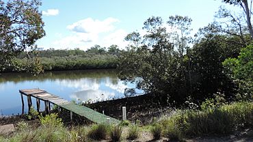
Coochin Creek as seen from The Esplanade, 2019
|
|||||||||||||||
| Population | 76 (2021 census) | ||||||||||||||
| • Density | 0.923/km2 (2.39/sq mi) | ||||||||||||||
| Postcode(s) | 4519 | ||||||||||||||
| Area | 82.3 km2 (31.8 sq mi) | ||||||||||||||
| Time zone | AEST (UTC+10:00) | ||||||||||||||
| Location | |||||||||||||||
| LGA(s) | Sunshine Coast Region | ||||||||||||||
| County | Canning | ||||||||||||||
| Parish | Beerwah | ||||||||||||||
| State electorate(s) |
|
||||||||||||||
| Federal Division(s) | Fisher | ||||||||||||||
|
|||||||||||||||
Coochin Creek is a small coastal area in the southern part of the Sunshine Coast Region in Queensland, Australia. It's named after the Coochin Creek, a waterway that flows through the area.
In 2021, about 76 people lived in Coochin Creek. It's a quiet place with lots of nature.
Contents
Exploring Coochin Creek's Geography
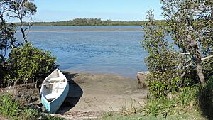
Coochin Creek is on the mainland coast. However, it doesn't face the open ocean. Instead, it looks out onto the Pumicestone Passage. This passage is a narrow water channel. It separates the mainland from Bribie Island. The passage here has many small, unnamed islands covered in mangroves.
The Coochin Creek itself starts in Beerwah. It flows into Coochin Creek locality from the west. Then, it moves towards the southwest. Finally, it joins the Pumicestone Passage. The name Coochin comes from the Kabi language. Kut'dhin means "red clay" or "pigment." This was used for body painting by Aboriginal people.
Wild Horse Mountain is in the southwest of the area. It stands about 123 meters (404 feet) tall. You can find a lookout there.
An old, abandoned town called Campbellville is also in Coochin Creek. It's located near where Coochin Creek meets Mellum Creek.
Much of Coochin Creek is protected land. This includes parts of Beerburrum State Forest. It also has Beerburrum East State Forest. There are also seven sections of the Pumicestone National Park. These areas help protect the natural environment. The small developed part of Coochin Creek is along the northern bank of the creek. It has some farms, mostly for growing plants, and a few houses. There are also many marshy areas along the creek and coast.
A Glimpse into Coochin Creek's Past
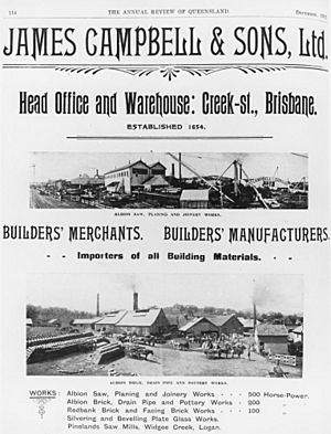
Coochin Creek has an interesting history. A man named James Campbell had a sawmill in Brisbane. A sawmill is a place where logs are cut into timber. Logs were brought from the Blackall Range and Caboolture River. They were floated down the Pumicestone Passage.
In 1881, James Campbell decided to build a new sawmill. He chose a spot on Coochin Creek. This was near where it joined Mellum Creek. The cut timber was then sent to Brisbane. At first, they used sailing boats called cutters. Later, they used paddlesteamers, which are boats powered by large wheels.
Campbellville: A Lively Timber Town
A small town called Campbellville grew around the sawmill. About 100 people lived there. A mail service started in 1883. Soon after, a Post Office opened in Campbellville. It closed in 1891. The town had a wharf with cranes for moving timber. There was also a temporary school and a cemetery.
Campbellville was a very social place. James Campbell was known for treating his workers well. He was one of the first to give his workers the "Eight-hour day." This meant 8 hours for work, 8 hours for rest, and 8 hours for fun. He believed employers should be kind to their workers.
The town had many clubs. There was a cricket team, an athletics club, and a football team. Everyone loved dancing! Dances were held often in Campbellville and nearby towns. These events included big dinners, singers, and actors. Then, the floor was cleared for dancing. News of these social gatherings often appeared in the Brisbane Courier newspaper.
The End of Campbellville
Campbellville's story ended in 1890. The sawmill closed down. A new railway line, the North Coast railway line, made it easier to transport timber by train. So, James Campbell and his sons moved their mill to Albion in Brisbane.
With no work, families moved to other timber towns. Some buildings from Campbellville were moved to Caloundra. Others were destroyed by bushfires in 1894 and 1902. Today, the most visible sign of the old town is its cemetery.
James Campbell and Sons continued to log trees in the area until the 1930s. But the timber was sent by rail to Brisbane for milling. The Campbell family also had a holiday house at the mouth of Coochin Creek. It was called "The Bar House."
During the 1930s, a tough economic time called the Great Depression, unemployed workers planted pine trees in the area. These new forests gradually covered the land where Campbellville once stood.
Schools in Coochin Creek
The first Coochin Creek Provisional School opened in 1888. It became Coochin Creek State School in 1909. In 1928, it was renamed Beerwah State School. A second Coochin Creek State School opened in 1952 but closed in 1962.
Places to See and Do
Local Attractions
Wild Horse Mountain Lookout is a popular spot for visitors. From here, you can enjoy great views of the surrounding area.
Camping and Amenities
There is a camping area available off Roys Road. It is managed by the Queensland Government. This offers a place for people to stay and enjoy nature.
Learning in the Area
Coochin Creek does not have its own schools. Students usually attend primary schools in nearby towns. These include Landsborough State School, Beerwah State School, and Beerburrum State School. For high school, students go to Baringa State Secondary College or Beerwah State High School.
Heritage Sites
Coochin Creek has some important historical places. These are called heritage listings. One such site is the Campbellville Settlement and Cemetery on Roys Road. It reminds us of the old timber town.


