
Cotonou facts for kids
Quick facts for kids
Cotonou
|
|||
|---|---|---|---|

View of Cotonou in 2019
|
|||
|
|||

Cotonou
Location in Benin
|
|||
| Country | |||
| Department | Littoral Department | ||
| Area | |||
| • Total | 79 km2 (31 sq mi) | ||
| Elevation | 51 m (167 ft) | ||
| Population
(2013 census)
|
|||
| • Total | 679,012 | ||
| • Density | 8,600/km2 (22,260/sq mi) | ||


Cotonou is the largest city in Benin. About 679,012 people officially live there, but more than two million live in the wider city area. The city is still growing, especially towards the west.
Cotonou is located in the southeast of Benin. It sits between the Atlantic Ocean and Lake Nokoué. Even though Porto-Novo is the official capital, Cotonou is where the government of Benin does most of its work.
Contents
History of Cotonou
.jpg)
The name "Cotonou" means "by the river of death" in the Fon language. In the early 1800s, Cotonou was a small fishing village. King Ghezo of Dahomey is thought to have officially founded it in 1830.
The village grew into an important trading center. In 1851, the French Second Republic made a deal with King Ghezo. This allowed them to set up a trading post in Cotonou. Later, under King Glele (1858–89), the land was given to the Second French Empire in 1878.
In 1883, the French Navy took over the city. They wanted to stop the British from taking control of the area. After King Glele died in 1889, King Béhanzin tried to challenge the agreement, but he was not successful. The town grew very quickly after a harbor was built in 1908. In 1960, the population was only 70,000 people.
Geography and Location

Cotonou is on a narrow strip of land. This land is between Lake Nokoué and the Atlantic Ocean. A canal called the lagoon of Cotonou cuts the city in half. The French dug this canal in 1855. There are three bridges that cross this canal. The Ouémé River also flows into the Atlantic Ocean right at Cotonou.

The city has good ways to get around. This includes air, sea, and land routes. There are also river routes to Porto Novo. These routes help Cotonou trade with nearby countries like Nigeria, Niger, Burkina Faso, and Togo.
For many years, the coast near Cotonou has been losing land to the sea. This problem got worse after the Nangbeto Dam and the deep-water port of Cotonou were built in 1961. A study showed that the coast east of Cotonou had moved back by 400 meters in 40 years. This has caused many people to move away from their homes along the coast.
Climate in Cotonou
Cotonou has a tropical wet and dry climate. This means it has two rainy seasons and two dry seasons. The rainy seasons are from April to July and from September to October. During these times, Cotonou gets about 800 to 1200 millimeters of rain each year.
In December and January, the city experiences harmattan winds. These winds are dry and dusty. Temperatures in Cotonou stay quite steady all year. The average high temperature is around 30°C, and the average low is about 25°C.
| Climate data for Cotonou (1991–2020, extremes 1910–present) | |||||||||||||
|---|---|---|---|---|---|---|---|---|---|---|---|---|---|
| Month | Jan | Feb | Mar | Apr | May | Jun | Jul | Aug | Sep | Oct | Nov | Dec | Year |
| Record high °C (°F) | 36.1 (97.0) |
38.6 (101.5) |
36.0 (96.8) |
35.4 (95.7) |
39.0 (102.2) |
33.0 (91.4) |
33.5 (92.3) |
31.8 (89.2) |
31.6 (88.9) |
33.4 (92.1) |
35.4 (95.7) |
36.6 (97.9) |
39.0 (102.2) |
| Mean daily maximum °C (°F) | 31.6 (88.9) |
32.2 (90.0) |
32.3 (90.1) |
32.0 (89.6) |
31.3 (88.3) |
29.6 (85.3) |
28.5 (83.3) |
28.2 (82.8) |
29.0 (84.2) |
30.1 (86.2) |
31.6 (88.9) |
31.9 (89.4) |
30.7 (87.3) |
| Daily mean °C (°F) | 28.0 (82.4) |
29.2 (84.6) |
29.6 (85.3) |
29.2 (84.6) |
28.4 (83.1) |
27.1 (80.8) |
26.5 (79.7) |
26.2 (79.2) |
26.7 (80.1) |
27.3 (81.1) |
28.4 (83.1) |
28.4 (83.1) |
27.9 (82.2) |
| Mean daily minimum °C (°F) | 24.4 (75.9) |
26.0 (78.8) |
26.8 (80.2) |
26.3 (79.3) |
25.4 (77.7) |
24.5 (76.1) |
24.4 (75.9) |
24.1 (75.4) |
24.3 (75.7) |
24.5 (76.1) |
25.3 (77.5) |
24.9 (76.8) |
25.1 (77.2) |
| Record low °C (°F) | 17.0 (62.6) |
17.9 (64.2) |
18.5 (65.3) |
20.7 (69.3) |
19.6 (67.3) |
20.0 (68.0) |
18.8 (65.8) |
19.8 (67.6) |
20.0 (68.0) |
19.1 (66.4) |
21.0 (69.8) |
17.9 (64.2) |
17.0 (62.6) |
| Average precipitation mm (inches) | 19.4 (0.76) |
38.2 (1.50) |
80.5 (3.17) |
126.1 (4.96) |
213.0 (8.39) |
333.2 (13.12) |
135.2 (5.32) |
39.0 (1.54) |
134.9 (5.31) |
165.1 (6.50) |
43.9 (1.73) |
12.1 (0.48) |
1,340.6 (52.78) |
| Average precipitation days (≥ 1.0 mm) | 2 | 3 | 6 | 9 | 14 | 18 | 11 | 9 | 14 | 13 | 5 | 1 | 105 |
| Average relative humidity (%) | 75.5 | 77.3 | 78.2 | 79.8 | 81.3 | 84.1 | 84.2 | 83.7 | 83.8 | 83.1 | 80.6 | 77.9 | 80.8 |
| Mean monthly sunshine hours | 188.8 | 188.3 | 213.5 | 209.7 | 196.5 | 137.7 | 141.3 | 150.8 | 155.1 | 200.9 | 233.0 | 219.1 | 2,234.7 |
| Source 1: NOAA | |||||||||||||
| Source 2: Meteo Climat (record highs and lows) | |||||||||||||
People of Cotonou

Here's how the population of Cotonou has grown:
- 1979: 320,348 people
- 1992: 536,827 people
- 2002: 665,100 people
- 2013: 679,012 people
French is the official language of Benin. Other languages spoken in Cotonou include Fon, Aja, and Yoruba.
Getting Around Cotonou
.jpg)
The Autonomous Port of Cotonou is one of the biggest ports in West Africa. A railway connects the city to Parakou in the north of Benin. Cotonou International Airport has flights to other capital cities in the region and to France. It also connects to major cities within Benin.
Roads link Cotonou to neighboring countries like Nigeria, Burkina Faso, Niger, and Togo. A very common way to travel in the city is by motorcycle-taxi. These are known locally as zémidjans. In 2015, a new passenger railway line was being built between Cotonou and Pahou.
Economy and Industry


Cotonou produces many important goods. These include palm oil, textiles, and cement. Factories in the city also assemble motor vehicles and bicycles. There are also sawmills.
Major exports from Cotonou include petroleum products, bauxite, and iron. There are also platforms offshore that drill for oil. The city is a big center for selling cars, with European brands sold in large outdoor lots. In the past, some car companies even assembled cars there.
Around 2012, challenges at sea caused trade at the port of Cotonou to decrease. In the Missèbo area, there is a large textile market. This market mainly sells African print fabrics and is run by Indian sellers.
Places of Worship
-
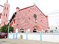
Cotonou Cathedral (a Catholic Church)
-
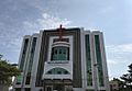
Temple Salem de Cotonou (Assemblies of God)
-
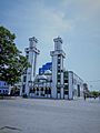
Mosquée centrale de Cotonou (Islam)


Cotonou has many places of worship. Christian churches are very common. These include the Roman Catholic Archdiocese of Cotonou (part of the Catholic Church), the Protestant Methodist Church in Benin, and the Union of Baptist Churches of Benin. Other Christian groups like Living Faith Church Worldwide, Redeemed Christian Church of God, and Assemblies of God also have churches there. There are also many Muslim mosques in the city.
Education in Cotonou

Cotonou is home to several universities and educational institutions:
- University of Science and Technology of Benin (Université des sciences et technologies du Bénin)
- African University of Technology and Management (Université africaine de technologie et de management)
The African University Institute Foundation (AUi Foundation) is also based in Cotonou. It is one of the largest educational foundations in Africa. The city also has some well-known private universities:
- African University of Benin (AUB)
- Ecole Superieure de Gestion de Technologie (ESGT UNIVERSITY BENIN)
- Ecole Supérieure D’Administration, D’Economie, De Journalisme Et Des Métiers De L’Audiovisuel (ESAE UNIVERSITY BENIN)
- Institut Superieur de Communication d’Organisation et de Management
- Iscom University Benin
Media
The Office de Radiodiffusion et Télévision du Bénin (ORTB) is based in Cotonou. This is the national television and radio operator for Benin.
Sister Cities
Cotonou has special partnerships with other cities around the world:
 Atlanta, United States
 Salvador da Bahia, Brazil
 Taipei City, Taiwan (since 1967)
See also
 In Spanish: Cotonú para niños
