Coyote Creek (San Gabriel River tributary) facts for kids
Quick facts for kids Coyote Creek |
|
|---|---|

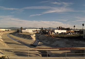
North Fork of Coyote Creek in La Mirada
|
|

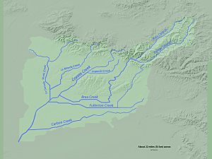
Map of the Coyote Creek watershed
|
|
| Country | United States |
| State | California |
| Counties | Orange County, Riverside County, Los Angeles, San Bernardino |
| Cities | Brea, Buena Park, Fullerton, La Habra, La Palma |
| Physical characteristics | |
| Main source | Riverside County, Orange County, California 2,300 ft (700 m) 33°56′49″N 117°57′31″W / 33.94694°N 117.95861°W |
| River mouth | San Gabriel River 0 ft (0 m) 33°47′41″N 118°05′24″W / 33.79472°N 118.09000°W |
| Length | 13.7 mi (22.0 km) |
| Basin features | |
| Basin size | 41.3 sq mi (107 km2) |
| Tributaries |
|
Coyote Creek is an important stream in Southern California. It flows into the San Gabriel River. This creek runs through parts of Orange County, Los Angeles County, and Riverside County, California.
The creek's watershed covers about 41.3 square miles (107 km2). This area includes five major cities: Brea, Buena Park, Fullerton, La Habra, and La Palma. Smaller streams that flow into Coyote Creek are called tributaries. Some main tributaries are Brea Creek, Fullerton Creek, and Carbon Creek. The watershed is mostly flat, but it has some low mountains. These include the Chino Hills, Puente Hills, and West Coyote Hills.
Contents
Coyote Creek's Path and Flow
Coyote Creek is about 13.7 miles (22.0 km) long. It generally flows towards the southwest. Its North Fork, also known as La Canada Verde Creek, is about 9.1 miles (14.6 km) long. The longest tributary is Carbon Creek, which flows for 13.6 miles (21.9 km). Fullerton Creek is also long, at 13.0 miles (20.9 km).
Two large reservoirs help control floods in the area. Brea Reservoir feeds into Brea Creek, and Fullerton Reservoir feeds into Fullerton Creek. Coyote Creek eventually joins the San Gabriel River near Long Beach.
Where Coyote Creek Begins
Coyote Creek starts with two branches near the border of Los Angeles and Orange County. It flows south, then west, picking up water from smaller streams. The creek then turns southwest. It flows through special flood control channels. These channels can be made of concrete, earth, or riprap (loose rocks).
After crossing the Los Angeles-Orange County border a few times, Coyote Creek meets Brea Creek. Brea Creek is about 9.8 miles (15.8 km) long.
Brea Creek's Journey
Brea Creek starts in the northeastern part of the watershed. This is near the border of Los Angeles and San Bernardino counties. It flows southwest, getting water from many mountain streams. Brea Creek briefly turns north and meets Tonner Canyon.
Tonner Canyon flows into Brea Creek. After they join, the stream is called Brea Creek. It then flows into Brea Reservoir. This reservoir helps prevent floods. Finally, Brea Creek flows west and joins Coyote Creek.
North Fork and Fullerton Creek
After Brea Creek joins, Coyote Creek continues southwest. It goes under Interstate 5. Soon after, the North Fork, or La Canada Verde Creek, joins Coyote Creek. This North Fork is about 9.1 miles (14.6 km) long. It starts with three branches that come together and flow south. It also gets water from La Mirada Creek.
After the North Fork, Fullerton Creek joins Coyote Creek. Fullerton Creek starts south of Tonner Canyon. It flows into Fullerton Reservoir, which also helps with flood control. Fullerton Creek then flows through neighborhoods before joining Coyote Creek. The combined waters then flow under California State Route 91.
A smaller stream called Moody Creek joins Coyote Creek a few miles later. Moody Creek is about 3.7 miles (6.0 km) long.
Carbon Creek's Path
The fourth main tributary, Carbon Creek, then joins Coyote Creek. Carbon Creek is about 13.6 miles (21.9 km) long. Most of it flows through a channel. It starts about 10 miles (16 km) south of Brea and Tonner Canyons. Carbon Creek flows west and south into small flood-control areas. It then continues west-southwest, picking up more small streams. Carbon Creek joins Coyote Creek very close to where Coyote Creek meets the San Gabriel River.
How Much Water Flows in the Creek?
The United States Geological Survey (USGS) measures how much water flows in Coyote Creek. They had two measuring stations, called stream gauges.
From 1965 to 1978, a station at Los Alamitos, California measured the flow. This is where Coyote Creek meets the San Gabriel River. The highest flow recorded there was 14,300 cubic feet per second (400 m3/s). This means 14,300 cubic feet of water passed by every second.
For Fullerton Creek, the USGS had two stations from 1936 to 1964. The highest flow recorded was 1,600 cubic feet per second (45 m3/s) on March 14, 1941.
For Carbon Creek, one station measured flow from 1962 to 2008. The highest flow recorded was 741 cubic feet (21.0 m3) per second on February 19, 2005.
Coyote Creek's Watershed
Land and Rocks Around the Creek
The Coyote Creek watershed is shaped a bit like a diamond. It sits between the areas drained by the San Gabriel and Santa Ana rivers. Small mountain ranges like the Chino Hills, Puente Hills, and West Coyote Hills form its northern edge.
Most of the watershed is developed with cities and towns. This is different from the San Gabriel River watershed, which is only about 26% developed. Some natural areas remain, like Chino Hills State Park.
Plants and Animals
Even though parts of Coyote Creek are changed into channels, it still provides homes for many plants and animals. Along the creek, you can find plants that like water, like salt marsh plants. Other areas have coastal sage scrub, live oak trees, grasslands, and even sand dunes.
Native wildlife lives in these areas, especially in the upper parts of the watershed like Brea and Tonner canyons. However, some invasive species (plants and animals that are not native and can harm the environment) also live there.
History of Coyote Creek
The Army Corps of Engineers started working on Coyote Creek in the early 1960s. They made the creek wider and lined parts of it with concrete. This was done to help control floods.
 | Victor J. Glover |
 | Yvonne Cagle |
 | Jeanette Epps |
 | Bernard A. Harris Jr. |

