Dakota County, Nebraska facts for kids
Quick facts for kids
Dakota County
|
|
|---|---|

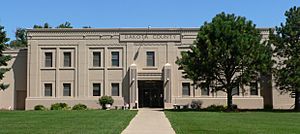
Dakota County courthouse in Dakota City
|
|

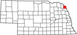
Location within the U.S. state of Nebraska
|
|
 Nebraska's location within the U.S. |
|
| Country | |
| State | |
| Founded | March 7, 1855 |
| Named for | Dakota people |
| Seat | Dakota City |
| Largest city | South Sioux City |
| Area | |
| • Total | 267 sq mi (690 km2) |
| • Land | 264 sq mi (680 km2) |
| • Water | 3.2 sq mi (8 km2) 1.2%% |
| Population
(2020)
|
|
| • Total | 21,582 |
| • Density | 76.5/sq mi (29.5/km2) |
| Time zone | UTC−6 (Central) |
| • Summer (DST) | UTC−5 (CDT) |
| Congressional district | 3rd |
Dakota County is a county in the state of Nebraska, USA. In 2020, about 21,582 people lived there. The main town, or county seat, is Dakota City.
Dakota County is part of the larger Sioux City metropolitan area. This means it's connected to Sioux City, a bigger city nearby.
In Nebraska, cars used to have license plates with numbers that showed which county they were from. Dakota County was number 70. This meant it had the 70th most registered vehicles in 1922. Even though some counties changed to letters and numbers, Dakota County decided to keep its number system.
Contents
History of Dakota County
For thousands of years, different groups of Native Americans lived along the Missouri River. Around 1775, the Omaha people settled west of the Missouri River. They built a large village called Ton-wa-tonga, which means "Big Village." About 1,100 people lived there.
The Omaha people were important in fur trading. They traded with other tribes and with French-Canadian traders. They were also one of the first tribes on the Northern Plains to use horses.
European-American settlers officially created Dakota County in 1855. They named it after the Dakota Sioux tribe. This tribe was very powerful in the areas that are now Nebraska and South Dakota. By this time, the Omaha people lived further south in Nebraska.
In May 2020, Dakota County had a high number of COVID-19 cases for its size. Many of these cases were linked to a large meat packing plant in Dakota City. By July 2020, there were 1,634 cases and 38 deaths reported.
Geography and Location
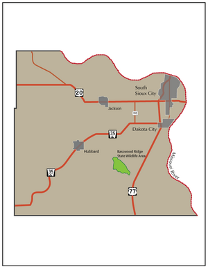
Dakota County is located in the northeast part of Nebraska. Its eastern border is the Missouri River. Across the river are the states of South Dakota and Iowa. The county has rolling hills and flat areas near the river.
The US Census Bureau says Dakota County covers about 267 square miles. Most of this is land (264 square miles), and a small part is water (3.2 square miles). It is the second smallest county in Nebraska by land area.
Main Roads in Dakota County
 Interstate 129
 U.S. Highway 20
 U.S. Highway 75
 U.S. Highway 77
 Nebraska Highway 9
 Nebraska Highway 12
 Nebraska Highway 35
 Nebraska Highway 110
Neighboring Counties
- Union County, South Dakota - to the northeast
- Woodbury County, Iowa - to the east
- Thurston County - to the south
- Dixon County - to the west
Population and People
| Historical population | |||
|---|---|---|---|
| Census | Pop. | %± | |
| 1860 | 819 | — | |
| 1870 | 2,040 | 149.1% | |
| 1880 | 3,213 | 57.5% | |
| 1890 | 5,386 | 67.6% | |
| 1900 | 6,286 | 16.7% | |
| 1910 | 6,564 | 4.4% | |
| 1920 | 7,694 | 17.2% | |
| 1930 | 9,505 | 23.5% | |
| 1940 | 9,836 | 3.5% | |
| 1950 | 10,401 | 5.7% | |
| 1960 | 12,168 | 17.0% | |
| 1970 | 13,137 | 8.0% | |
| 1980 | 16,573 | 26.2% | |
| 1990 | 16,742 | 1.0% | |
| 2000 | 20,253 | 21.0% | |
| 2010 | 21,006 | 3.7% | |
| 2020 | 21,582 | 2.7% | |
| 2022 (est.) | 21,042 | 0.2% | |
| US Decennial Census 1790-1960 1900-1990 1990-2000 2010-2013 2020-2022 |
|||
In 2020, the population of Dakota County was 21,582 people. The county is very diverse. About 43.3% of people were non-Hispanic White. About 40.8% of people were Hispanic. There were also African American and Asian residents.
In 2010, about 39.7% of the people were Hispanic or Latino. Many people in the county have German or Irish family backgrounds.
Towns and Villages
Cities
- Dakota City (This is the county seat, the main town for county government.)
- South Sioux City
Villages
Unincorporated Communities
These are smaller places that are not officially cities or villages.
Politics and Voting
For many years, people in Dakota County have mostly voted for the Republican Party in national elections. Since 1952, the county has voted Republican more than 80% of the time. However, because there is a large Hispanic population, the difference in votes is not as big as in some other rural counties in Nebraska.
| Year | Republican | Democratic | Third party | |||
|---|---|---|---|---|---|---|
| No. | % | No. | % | No. | % | |
| 2024 | 3,934 | 64.09% | 2,109 | 34.36% | 95 | 1.55% |
| 2020 | 3,926 | 57.59% | 2,744 | 40.25% | 147 | 2.16% |
| 2016 | 3,616 | 57.59% | 2,314 | 36.85% | 349 | 5.56% |
| 2012 | 3,094 | 50.42% | 2,922 | 47.62% | 120 | 1.96% |
| 2008 | 3,292 | 51.47% | 2,994 | 46.81% | 110 | 1.72% |
| 2004 | 3,526 | 53.30% | 3,027 | 45.76% | 62 | 0.94% |
| 2000 | 3,119 | 51.46% | 2,695 | 44.46% | 247 | 4.08% |
| 1996 | 2,592 | 43.31% | 2,632 | 43.98% | 761 | 12.72% |
| 1992 | 2,793 | 43.21% | 2,335 | 36.12% | 1,336 | 20.67% |
| 1988 | 2,744 | 48.17% | 2,942 | 51.64% | 11 | 0.19% |
| 1984 | 3,467 | 57.76% | 2,510 | 41.82% | 25 | 0.42% |
| 1980 | 3,165 | 57.67% | 1,930 | 35.17% | 393 | 7.16% |
| 1976 | 2,631 | 52.67% | 2,292 | 45.89% | 72 | 1.44% |
| 1972 | 2,879 | 62.22% | 1,748 | 37.78% | 0 | 0.00% |
| 1968 | 2,383 | 56.60% | 1,541 | 36.60% | 286 | 6.79% |
| 1964 | 1,906 | 41.80% | 2,654 | 58.20% | 0 | 0.00% |
| 1960 | 2,977 | 56.13% | 2,327 | 43.87% | 0 | 0.00% |
| 1956 | 2,516 | 53.08% | 2,224 | 46.92% | 0 | 0.00% |
| 1952 | 2,643 | 57.38% | 1,963 | 42.62% | 0 | 0.00% |
| 1948 | 1,379 | 36.76% | 2,372 | 63.24% | 0 | 0.00% |
| 1944 | 1,703 | 46.13% | 1,989 | 53.87% | 0 | 0.00% |
| 1940 | 2,140 | 46.91% | 2,422 | 53.09% | 0 | 0.00% |
| 1936 | 1,264 | 29.52% | 2,741 | 64.01% | 277 | 6.47% |
| 1932 | 863 | 21.92% | 3,044 | 77.32% | 30 | 0.76% |
| 1928 | 1,709 | 49.35% | 1,754 | 50.65% | 0 | 0.00% |
| 1924 | 1,235 | 39.38% | 964 | 30.74% | 937 | 29.88% |
| 1920 | 1,525 | 62.58% | 873 | 35.82% | 39 | 1.60% |
| 1916 | 612 | 36.45% | 1,032 | 61.47% | 35 | 2.08% |
| 1912 | 408 | 28.53% | 612 | 42.80% | 410 | 28.67% |
| 1908 | 729 | 48.96% | 716 | 48.09% | 44 | 2.96% |
| 1904 | 855 | 63.52% | 399 | 29.64% | 92 | 6.84% |
| 1900 | 692 | 46.35% | 777 | 52.04% | 24 | 1.61% |
See also
 In Spanish: Condado de Dakota (Nebraska) para niños
 | Calvin Brent |
 | Walter T. Bailey |
 | Martha Cassell Thompson |
 | Alberta Jeannette Cassell |


