
Dalhart, Texas facts for kids
Quick facts for kids
Dalhart, Texas
|
|
|---|---|

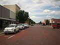
Streets paved with brick in downtown Dalhart
|
|
| Motto(s):
"The XIT City"
|
|

Location within Dallam County and Texas
|
|

Dalhart, Texas
Location in Texas

Dalhart, Texas
Location in the United States
|
|
| Country | United States |
| State | Texas |
| Counties | Dallam, Hartley |
| Area | |
| • Total | 4.79 sq mi (12.41 km2) |
| • Land | 4.78 sq mi (12.39 km2) |
| • Water | 0.01 sq mi (0.03 km2) |
| Elevation | 3,983 ft (1,214 m) |
| Population
(2020)
|
|
| • Total | 8,447 |
| • Density | 1,763.47/sq mi (680.66/km2) |
| Time zone | UTC−6 (Central (CST)) |
| • Summer (DST) | UTC−5 (CDT) |
| ZIP Code |
79022
|
| Area code | 806 |
| FIPS code | 48-18524 |
| GNIS feature ID | 2410286 |
Dalhart is a city in Texas, a state in the United States. It is located in both Dallam and Hartley counties. Dalhart is also the main city (county seat) of Dallam County. In 2020, about 8,447 people lived there.
Contents
History of Dalhart
Dalhart was started in 1901. Its name is a mix of the two counties it sits between: Dallam and Hartley. The city grew quickly because it was built where two railroad lines met.
In the 1930s, Dalhart was in the middle of the Dust Bowl. This was a time during the Great Depression when there was a long drought (no rain) and huge dust storms. A man named Tex Thornton claimed he could make it rain by firing special explosives into the clouds. He collected a lot of money from people who hoped for rain.
Where is Dalhart?
Dalhart is in the northwestern part of Texas. The city covers about 12.4 square kilometers (4.79 square miles). Only a tiny bit of this area is water.
Dalhart is in a flat area called the Southern Great Plains. Farming is a very important part of its economy. The city is about 70 miles northwest of Amarillo, which is the closest big city with over 100,000 people.
Major highways like U.S. Highway 54, 87, and 385 all meet in Dalhart.
Rita Blanca State Park
Just two miles south of Dalhart is the former Rita Blanca State Park. It is now managed by the City of Dalhart. This park has 1,680 acres of land and a 160-acre lake called Lake Rita Blanca. You can find playground equipment and trails for hiking, biking, and riding horses there. The city also has a Lake Center where you can borrow things like bicycles, board games, fishing poles, and golf discs.
Distance to State Capitals
Did you know Dalhart is closer to six other state capitals than it is to Austin, the capital of Texas?
- Santa Fe, New Mexico is 261 miles away.
- Oklahoma City, Oklahoma is 313 miles away.
- Denver, Colorado is 348 miles away.
- Cheyenne, Wyoming is 448 miles away.
- Topeka, Kansas is 461 miles away.
- Lincoln, Nebraska is 544 miles away.
- Austin, Texas, is 570 miles away.
Dalhart's Climate
Dalhart has a semiarid climate, which means it's usually dry. Winters are cool and dry, and summers are hot. The city gets less than 17 inches of rain each year. This low rainfall greatly affects how people farm there, especially with center pivot irrigation.
Since 1948, the hottest temperature recorded in Dalhart was 110°F (43°C) on June 26, 2011. The coldest was -21°F (-29°C) on January 4, 1959. On average, the temperature reaches 90°F (32°C) or higher about 65 afternoons a year. It freezes about 134 mornings a year.
| Climate data for Dalhart, Texas (Dalhart Municipal Airport) (1991–2020 normals, extremes 1948–present) | |||||||||||||
|---|---|---|---|---|---|---|---|---|---|---|---|---|---|
| Month | Jan | Feb | Mar | Apr | May | Jun | Jul | Aug | Sep | Oct | Nov | Dec | Year |
| Record high °F (°C) | 82 (28) |
89 (32) |
92 (33) |
96 (36) |
102 (39) |
110 (43) |
108 (42) |
106 (41) |
104 (40) |
96 (36) |
89 (32) |
82 (28) |
110 (43) |
| Mean maximum °F (°C) | 71.0 (21.7) |
75.8 (24.3) |
83.3 (28.5) |
88.5 (31.4) |
94.5 (34.7) |
101.1 (38.4) |
102.5 (39.2) |
99.7 (37.6) |
96.2 (35.7) |
89.5 (31.9) |
79.6 (26.4) |
71.0 (21.7) |
104.0 (40.0) |
| Mean daily maximum °F (°C) | 51.3 (10.7) |
54.9 (12.7) |
63.5 (17.5) |
71.0 (21.7) |
80.2 (26.8) |
90.2 (32.3) |
93.5 (34.2) |
91.1 (32.8) |
84.2 (29.0) |
72.6 (22.6) |
60.7 (15.9) |
50.5 (10.3) |
72.0 (22.2) |
| Daily mean °F (°C) | 36.3 (2.4) |
39.5 (4.2) |
47.2 (8.4) |
55.0 (12.8) |
64.9 (18.3) |
74.9 (23.8) |
78.7 (25.9) |
76.9 (24.9) |
69.5 (20.8) |
57.1 (13.9) |
45.1 (7.3) |
36.1 (2.3) |
56.8 (13.8) |
| Mean daily minimum °F (°C) | 21.4 (−5.9) |
24.1 (−4.4) |
30.9 (−0.6) |
39.0 (3.9) |
49.7 (9.8) |
59.6 (15.3) |
64.0 (17.8) |
62.8 (17.1) |
54.9 (12.7) |
41.6 (5.3) |
29.6 (−1.3) |
21.6 (−5.8) |
41.6 (5.3) |
| Mean minimum °F (°C) | 6.0 (−14.4) |
8.3 (−13.2) |
13.9 (−10.1) |
24.6 (−4.1) |
34.5 (1.4) |
48.7 (9.3) |
56.1 (13.4) |
55.0 (12.8) |
40.8 (4.9) |
25.6 (−3.6) |
12.8 (−10.7) |
5.4 (−14.8) |
1.2 (−17.1) |
| Record low °F (°C) | −21 (−29) |
−19 (−28) |
0 (−18) |
16 (−9) |
25 (−4) |
37 (3) |
49 (9) |
43 (6) |
27 (−3) |
9 (−13) |
−5 (−21) |
−12 (−24) |
−21 (−29) |
| Average precipitation inches (mm) | 0.47 (12) |
0.35 (8.9) |
0.93 (24) |
1.25 (32) |
1.69 (43) |
2.24 (57) |
2.51 (64) |
2.16 (55) |
1.29 (33) |
1.64 (42) |
0.53 (13) |
0.54 (14) |
15.60 (396) |
| Average snowfall inches (cm) | 4.2 (11) |
3.4 (8.6) |
3.0 (7.6) |
1.5 (3.8) |
0.0 (0.0) |
0.0 (0.0) |
0.0 (0.0) |
0.0 (0.0) |
0.0 (0.0) |
1.3 (3.3) |
1.9 (4.8) |
5.0 (13) |
20.3 (52) |
| Average precipitation days (≥ 0.01 in) | 2.9 | 2.8 | 4.2 | 4.9 | 6.4 | 7.5 | 7.6 | 8.2 | 5.1 | 4.1 | 3.4 | 3.4 | 60.5 |
| Average snowy days (≥ 0.1 in) | 1.8 | 2.0 | 1.6 | 0.9 | 0.1 | 0.0 | 0.0 | 0.0 | 0.0 | 0.8 | 1.1 | 2.1 | 10.4 |
| Source: NOAA | |||||||||||||
People in Dalhart
| Historical population | |||
|---|---|---|---|
| Census | Pop. | %± | |
| 1910 | 2,580 | — | |
| 1920 | 2,676 | 3.7% | |
| 1930 | 4,691 | 75.3% | |
| 1940 | 4,682 | −0.2% | |
| 1950 | 5,918 | 26.4% | |
| 1960 | 5,160 | −12.8% | |
| 1970 | 5,705 | 10.6% | |
| 1980 | 6,854 | 20.1% | |
| 1990 | 6,246 | −8.9% | |
| 2000 | 7,237 | 15.9% | |
| 2010 | 7,930 | 9.6% | |
| 2020 | 8,447 | 6.5% | |
| U.S. Decennial Census | |||
2020 Census Information
In 2020, Dalhart had 8,447 people. There were 2,956 households and 2,041 families living in the city.
| Race | Number | Percentage |
|---|---|---|
| White (NH) | 4,167 | 49.33% |
| Black or African American (NH) | 76 | 0.9% |
| Native American or Alaska Native (NH) | 48 | 0.57% |
| Asian (NH) | 29 | 0.34% |
| Pacific Islander (NH) | 6 | 0.07% |
| Some Other Race (NH) | 10 | 0.12% |
| Mixed/Multi-Racial (NH) | 173 | 2.05% |
| Hispanic or Latino | 3,938 | 46.62% |
| Total | 8,447 |
2010 Census Information
In 2010, Dalhart had 7,930 people. About 50.3% were male and 49.7% were female.
- 28.9% of the people were under 18 years old.
- 12.4% of the people were over 65 years old.
Most people (84.0%) identified as White. About 34.0% of the population identified as Hispanic or Latino. In 2010, about 9.9% of the people were born in another country. In 25.4% of homes, a language other than English was spoken most often.
About 79.6% of adults over 25 had finished high school. About 16.4% had a college degree or higher. The average household income between 2007 and 2011 was $69,190. About 6.4% of the people lived below the poverty line. Most Dalhart residents (71.1%) owned their homes.
Dalhart's Economy
.jpg)


Dalhart's economy is mostly about agribusiness. This means it focuses on farming, ranching, and raising animals. There are large feedlots (places where animals are fed before being sold) and big pig farms. A cheese processing plant also opened recently. Dalhart also has a state prison.
Long ago, the land was mostly covered in natural grass. Some areas were used for dry farming, but there wasn't enough rain. Later, people started using irrigation to water their crops. A new way of watering, called center pivot irrigation, was perfect for the sandy soil. Around the same time, large feedlots were built because the climate was dry. This created a good market for corn, which is now the main crop grown in the area.
In the mid-2000s, Dalhart attracted large dairy farms. This was because of tax benefits and fewer environmental rules in Texas. In 2007, Hilmar Cheese Company opened a big cheese factory in Dalhart. This factory and the dairy farms around it have created many jobs. The international farming company Cargill also has a huge hog farm near Dalhart.
Fun Things to Do in Dalhart
Dalhart is known as the "XIT City." This is because of its connection to the famous XIT Ranch. This ranch was a huge piece of land, about 3 million acres! It was traded for the building of the Texas State Capitol in Austin. The ranch closed in 1912, but its history is celebrated in Dalhart.
XIT Museum and Rodeo
You can learn about the ranch at the XIT Museum. Every August, Dalhart hosts the XIT Rodeo and Reunion. This event includes the world's largest free barbecue! There are also junior rodeo events, professional rodeo competitions, and live music for three nights.
Muscle Car Party Weekend
Another fun event is the Muscle Car Party Weekend, held every May. It features a classic car show, bicycle drag races, and a dinner and dance. The Dalhart Cruzers Car Club organizes these events and even raffles off a classic car each year!
Education in Dalhart
The Dalhart Independent School District serves the city. It has an elementary school, an intermediate school, a junior high school, and a high school. Students attend Dalhart High School. In 2012, Frank Phillips College opened a branch in Dalhart. It offers both college credit classes and community education classes.
News in Dalhart
The Dalhart Texan is the local newspaper. It was started in 1901 and is published twice a week. The Hogue family has owned the newspaper for over 60 years.
Other Important Places
Prison System
The Texas Department of Criminal Justice has a prison called the Dalhart Unit located near the city in Hartley County.
Images for kids
-
Streets paved with brick in downtown Dalhart
-

Location within Dallam County and Texas
-
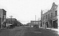
Dalhart, around 1910–1930
-
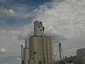
Dalhart Consumers grain elevator
-
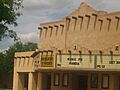
The former Mission Twins Theater in downtown Dalhart.
See also
 In Spanish: Dalhart (Texas) para niños
