Delta County, Michigan facts for kids
Quick facts for kids
Delta County
|
|
|---|---|

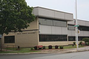
Delta County Courthouse in Escanaba
|
|

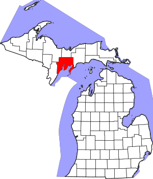
Location within the U.S. state of Michigan
|
|
 Michigan's location within the U.S. |
|
| Country | |
| State | |
| Founded | March 9, 1843 (authorized) 1861 (organized) |
| Named for | Greek letter Delta |
| Seat | Escanaba |
| Largest city | Escanaba |
| Area | |
| • Total | 1,991 sq mi (5,160 km2) |
| • Land | 1,171 sq mi (3,030 km2) |
| • Water | 820 sq mi (2,100 km2) 41%% |
| Population
(2020)
|
|
| • Total | 36,903 |
| • Density | 32/sq mi (12/km2) |
| Time zone | UTC−5 (Eastern) |
| • Summer (DST) | UTC−4 (EDT) |
| Congressional district | 1st |
Delta County is a county located in the Upper Peninsula of Michigan, a U.S. state. A county is like a smaller region within a state, often with its own local government. In 2020, about 36,903 people lived here. The main city and county seat (where the county government is) is Escanaba.
Delta County was first mapped out in 1843 and officially started in 1861. Its name comes from the Greek letter Delta (Δ). This letter looks like a triangle, which was the shape of the county when it was first created. Back then, it included parts of other nearby counties like Menominee and Marquette. Today, fun activities like outdoor recreation and products from forests are big industries here. Farmers in Delta County grow crops such as hay, corn, potatoes, and strawberries.
Delta County is also part of the Escanaba, MI Micropolitan Statistical Area. This means it's a smaller city area with strong economic ties to Escanaba.
Contents
Geography of Delta County
According to the U.S. Census Bureau, Delta County covers a total area of 1,991 square miles. About 1,171 square miles of this is land, and 820 square miles (or 41%) is water. This makes it the fifth-largest county in Michigan by land area.
Counties Nearby
Delta County shares borders with several other counties.
By land
- Menominee County (to the southwest)
- Marquette County (to the northwest)
- Alger County (to the north)
- Schoolcraft County (to the east)
By water
- Leelanau County (to the southeast)
- Door County, Wisconsin (to the south)
Protected Natural Areas
- A part of the Hiawatha National Forest is located within Delta County. This is a large area of protected forest land.
Communities in Delta County

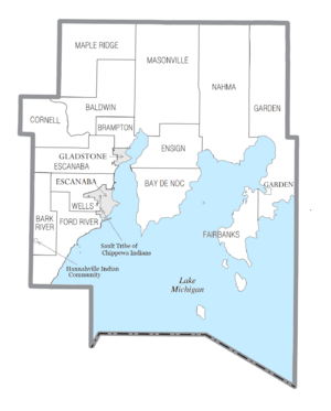
Delta County has several different types of communities, from cities to small villages.
Cities
Village
Civil Townships
- Baldwin Township
- Bark River Township
- Bay de Noc Township
- Brampton Township
- Cornell Township
- Ensign Township
- Escanaba Township
- Fairbanks Township
- Ford River Township
- Garden Township
- Maple Ridge Township
- Masonville Township
- Nahma Township
- Wells Township
Unincorporated Communities
- Bark River
- Brampton
- Chaison
- Fairport
- Fayette
- Ford River
- Garden Corners
- Harris
- Hyde
- Isabella
- Island View
- Kipling
- Lake Bluff
- Maplewood
- Nahma
- Narenta
- Perkins
- Perronville
- Rapid River
- Riverland
- Rock
- St. Nicholas
- Schaffer
- Wells
- West Gladstone
Indian Reservations
- A small part of the Hannahville Indian Community is in Bark River Township. Most of their land is in Menominee County.
- The Sault Tribe of Chippewa Indians also has a very small area within the city limits of Escanaba.
Population Changes
| Historical population | |||
|---|---|---|---|
| Census | Pop. | %± | |
| 1860 | 1,172 | — | |
| 1870 | 2,542 | 116.9% | |
| 1880 | 6,812 | 168.0% | |
| 1890 | 15,330 | 125.0% | |
| 1900 | 23,881 | 55.8% | |
| 1910 | 30,108 | 26.1% | |
| 1920 | 30,909 | 2.7% | |
| 1930 | 32,280 | 4.4% | |
| 1940 | 34,037 | 5.4% | |
| 1950 | 32,913 | −3.3% | |
| 1960 | 34,298 | 4.2% | |
| 1970 | 35,924 | 4.7% | |
| 1980 | 38,947 | 8.4% | |
| 1990 | 37,780 | −3.0% | |
| 2000 | 38,520 | 2.0% | |
| 2010 | 37,069 | −3.8% | |
| 2020 | 36,903 | −0.4% | |
| 2023 (est.) | 36,790 | −0.8% | |
| US Decennial Census 1790-1960 1900-1990 1990-2000 2010-2018 |
|||
The 2010 United States census showed that Delta County had a population of 37,069 people. By the 2020 census, the population was 36,903.
Education in Delta County
Several school districts serve the students in Delta County:
- Bark River-Harris School District
- Big Bay de Noc School District
- Escanaba Area Public Schools
- Gladstone Area Schools
- Mid Peninsula School District
- Rapid River Public Schools
Transportation
Main Roads
 US 2 travels east to west through the southern part of the county.
 US 41 runs north to south through the middle of the county. It then goes southwest along the Lake Michigan shore.
 M-35 comes from Marquette County and goes southeast to Gladstone.
 M-69 crosses the southwestern tip of the county.
 M-183 goes from Fayette State Park to Garden Corners.
Airport
Delta County has its own airport, Delta County Airport (KESC), located southwest of Escanaba. This airport offers flights to major cities like Detroit and Minneapolis.
See also
 In Spanish: Condado de Delta (Míchigan) para niños
 | Kyle Baker |
 | Joseph Yoakum |
 | Laura Wheeler Waring |
 | Henry Ossawa Tanner |

