
Ecuadorian–Peruvian territorial dispute facts for kids
Quick facts for kids Ecuadorian-Peruvian Wars |
|||||||
|---|---|---|---|---|---|---|---|
| Part of the South American territorial disputes | |||||||
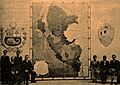
 Map of the disputed territories from 1916 onwards |
|||||||
|
|||||||
| Belligerents | |||||||
|
In 1828-1829 |
In 1828-1829 |
||||||
|
In 1858-1860 Supported by: |
In 1858-1860 Supported by: |
||||||
|
Incidents of 1903 and 1904 Diplomatic incident of 1910 In 1941 |
Incidents of 1903 and 1904 Diplomatic incident of 1910 In 1941 |
||||||
|
In 1978 In 1980 In 1995 Supported by: |
In 1978 In 1980
In 1995 |
||||||
The Ecuadorian–Peruvian territorial dispute was a long-standing disagreement between Ecuador and Peru about their shared border. For a time, Colombia was also involved. This dispute started because each country had a different idea of where the old Spanish colonial borders were.
After gaining independence from Spain, new South American countries agreed to use the 1810 Spanish borders as their own. This idea was called uti possidetis juris. However, different interpretations led to several armed conflicts between Ecuador and Peru.
The main dispute officially ended with the Rio de Janeiro Protocol in 1942. But disagreements continued, leading to two more wars: the Paquisha War in 1981 and the Cenepa War in 1995. Finally, on October 26, 1998, Ecuador and Peru signed a peace agreement. This agreement set up a way to mark the border, which began on May 13, 1999. Both countries' governments approved the agreement, bringing a final end to the dispute.
Contents
- How the Border Dispute Began
- Independence and New Nations
- Gran Colombia–Peru Conflict
- Early Treaties and Border Efforts (1832–1856)
- Ecuadorian–Peruvian War (1857–1860)
- Boundary Negotiations and Treaties (1860–1941)
- Ecuadorian–Peruvian War (1941)
- Paquisha War (1981)
- Cenepa War (1995)
- Arbitration and Final Resolution (1995–1998)
- Aftermath
- See also
- Images for kids
How the Border Dispute Began
Spanish Rule in South America
When Christopher Columbus arrived in 1492, Spain began to take control of lands in the Americas. Spanish explorers, called conquistadores, expanded the Spanish Crown's power. They eventually controlled much of Central and South America.
In 1528, the Spanish reached the Inca Empire. On November 16, 1532, Francisco Pizarro began the Spanish conquest of Peru. He took advantage of a civil war happening within the Inca Empire. Over the next few decades, Spain took firm control of the Andean region. They stopped many rebellions by the native people.
To manage these vast new lands, King Charles V created two large administrative areas called Viceroyalties in 1542. These were the Viceroyalty of New Spain (modern-day Mexico) and the Viceroyalty of Peru. The Viceroyalty of Peru was fully organized by 1572.
Dividing the Viceroyalty of Peru

The Viceroyalty of Peru was huge. It was far from the main government centers in Lima. So, it was divided into smaller regions called real audiencias. These were like major provinces with both judicial and executive power.
From 1542 to 1717, the Viceroyalty of Peru controlled most of South America. Its territory was split among several audiencias. Key ones included:
- Royal Audience of San Francisco of Quito (created in 1563)
- Royal Audience of the City of Kings Lima (created in 1543)
The specific borders of these audiencias were set by royal decrees. These laws were collected in books called the Laws of the Indies. The 1680 collection, called the Recopilación de las Leyes de los Reynos de Indias, was very important.
This collection described the districts of Lima and Quito. The Royal Audience of Quito included the Province of Quito. It stretched along the coast towards Paita (but not including it). Inland, it included towns like Jaén, Loja, and Guayaquil. Its western border was the Pacific Ocean, and its southern border was with the Audience of Lima.
The Royal Audience of Lima covered the coast from Lima south to Captaincy General of Chile (not including it). It went north to Paita (including it). Inland, it included places like Piura and Cajamarca. Its northern border was with the Royal Audience of Quito.
Creating New Granada
_-_Carta_IV_-_Virreinato_de_Santaf%C3%A9_y_Capitan%C3%ADa_General_de_Venezuela.jpg)
In 1717, King Philip V of Spain made a big change. He split off the northwestern part of Peru to create the Viceroyalty of New Granada. This new viceroyalty included what are now Colombia, Ecuador, Panama, and Venezuela. It also covered northern Peru and parts of Brazil and Guyana.
The Royal Audience of Quito, which was part of New Granada, included areas like Pasto and Popayán (in modern Colombia). It also extended south to Piura (in modern Peru). The eastern border in the Amazon region was not very clear at first.
In 1740, a new royal decree, called the Cédula de Reerección Definitiva del Virreinato de Nueva Granada, clearly defined the border between New Granada and Peru. This decree stated that the border started at the Tumbes River on the Pacific Coast. It then followed mountain ranges, leaving areas like Piura and Cajamarca to Peru. This was the first time the Tumbes River was mentioned as a boundary.
The Royal Decree of 1802

In 1802, the Spanish King Charles IV of Spain issued another important decree. This was called the Real Cédula of 1802. It moved the control of the Government and Commandancy General of Maynas and the Governorate of Quijos from New Granada (Quito) to the Viceroyalty of Peru.
This decree stated that Maynas and Quijos, including towns along the Napo River and other rivers flowing into the Marañón, would now be part of Peru. It also mentioned that towns like Lamas and Moyobamba should be part of this command. The decree aimed to help missionaries and protect Spanish lands from Portuguese expansion.
However, there was confusion about this decree. Some copies of the document were different, making its exact meaning unclear. Also, it wasn't clear if this change was only for military and church matters, or if it also changed the actual land borders. This lack of clarity caused problems for Ecuador and Peru when they became independent.
Many people, including the Viceroy of Santa Fe and the President of Quito, questioned the 1802 decree. They said it wasn't properly registered and couldn't be found in official archives. However, later findings in Maynas archives suggested the decree and its execution documents did exist.
Other Border Changes (1803–1818)
- 1803: The military affairs of Guayaquil, an important port city, were placed under Lima's control.
- 1810: All administrative and economic matters for Guayaquil were given to the Viceroyalty of Peru until 1819.
- 1812: A decree from the Spanish Courts tried to cancel the 1802 decree.
- 1816: The King of Spain issued a Royal Order that canceled the 1802 decree. This returned the province of Maynas to Quito.
- 1818: The Viceroy of Peru acknowledged the 1816 order, confirming Maynas' return to Quito.
Independence and New Nations
Birth of Gran Colombia
The Republic of Gran Colombia was formed in 1819, with Simón Bolívar as its president. The independence of what is now Colombia was won in 1819. Venezuela gained independence in 1821. General Antonio José de Sucre freed the territory that became Ecuador in 1822.
Gran Colombia included modern-day Colombia, Ecuador, Venezuela, and Panama. Simón Bolívar dreamed of uniting all of South America, but this dream was never fully achieved.
Even before the wars for independence ended, Bolívar set a rule for new country borders. This rule, uti possidetis juris, meant that new countries would have the same borders as the Spanish colonial areas in 1809. So, the Viceroyalty of Peru became the Republic of Peru. The Viceroyalty of New Granada became Gran Colombia.
However, border disputes arose because Peru based its claims on the 1802 decree. This decree gave Peru rights to Amazon territory. Gran Colombia, on the other hand, used the 1740 decree to define its borders with Peru.
- July 6, 1822: Monteagudo-Mosquera Treaty
- This treaty aimed to create an alliance against Spain. It also sought Peru's recognition of Guayaquil as part of Gran Colombia. The treaty was signed, but exact border details were left for a future agreement.
Gran Colombia–Peru Conflict
Bolívar wanted to keep Gran Colombia united. Peruvian President José de la Mar had his own ambitions. He wanted to restore the old Inca Empire by adding Ecuador and Bolivia to Peru. This led to a quick rivalry between Bolívar and De la Mar.
De la Mar started an anti-Bolívar campaign. This led to uprisings in Peru and Bolivia, where the Colombian Army was forced out. On June 3, 1828, De la Mar invaded southern Gran Colombia. He occupied Loja and tried to take Guayas, planning to add these lands to Peru.
Simón Bolívar declared war against Peru. Sucre led the Colombian Army. In 1829, De la Mar and General Agustín Gamarra occupied Cuenca. But Sucre defeated them at the Battle of Tarqui on February 27, 1829. A change in Peruvian leadership led to a peace treaty. The Convenio de Girón recognized the borders as they were before independence. The Piura Armistice recognized Guayaquil as part of Gran Colombia. The war officially ended on September 22, 1829.
- February 28, 1829: La Mar-Sucre Convention
- This agreement was signed after the Battle of Tarqui. It ended Peru's attempt to take parts of Gran Colombia by force.
- September 22, 1829: Larrea-Gual Treaty
- This treaty confirmed the uti possidetis principle. It allowed for small changes to create a more natural border. Both sides agreed to form a commission to set a permanent border.
Gran Colombia broke apart in 1830 due to political struggles. Ecuador became a separate country on May 13, 1830. Its first constitution, adopted on September 23, 1830, stated that Ecuador included the provinces of Azuay, Guayas, and Quito.
The Pedemonte-Mosquera Protocol
Ecuador and Colombia believe the Pedemonte-Mosquera Protocol was signed in Lima on August 11, 1830. This protocol aimed to settle the eastern border from the Andes to Brazil. It made the Marañón River and Amazon River the new border. It also set the western border from the Andes to the Pacific at the Macará and Tumbes rivers. However, a small area in the Andes, Jaén de Bracamoros, remained disputed.
Ecuador has used this protocol as key evidence for its claims. Peru, however, has questioned if this protocol ever truly existed.
- Peru argued that no original document has been found by Ecuador or Colombia.
- Peru also noted that the protocol was never approved by either country's government.
- Ecuador had separated from Gran Colombia a month before the supposed signing date.
Despite these doubts, Ecuador produced a copy made in 1870. This copy was from a personal collection and was sent by the Colombian embassy to Bogotá. Peru did not certify this copy, so it remains disputed.
Early Treaties and Border Efforts (1832–1856)
- February 10, 1832: Ecuador's Separation Recognized
- The Republic of Nueva Granada (Colombia) officially recognized Ecuador's separation. This formed the new nation of Ecuador.
- July 12, 1832: Pando-Noboa Treaty
- Peru recognized Ecuador as a new republic. They signed a treaty of friendship and trade. Article XIV stated that existing borders would be respected until a new agreement was made.
- 1841–1842: Border Negotiations Fail
- Ecuador demanded the return of Tumbes, Jaén, and Maynas. Peru refused, saying these areas were already Peruvian. Negotiations failed because Ecuador insisted on these territories.
- October 23, 1851: Peru-Brazil Treaty
- Peru set its eastern border with Brazil. However, Ecuador and Colombia protested. They said this border included disputed Amazon territories that they also claimed.
- March 10, 1853: Peru Creates Loreto Government
- Peru created a special Amazonian government called Loreto. This was to strengthen its claims to the disputed Amazon territory. Peru aimed to explore and settle these areas with Peruvian citizens. This would give Peru a stronger position if the dispute went to arbitration.
Ecuadorian–Peruvian War (1857–1860)
This war was fought over disputed land in the Amazon. In 1857, Ecuador decided to give land in the Canelos region to Britain. This was to pay off international debts from its war of independence. Peru immediately protested. Peru claimed the Canelos region belonged to it based on the 1802 decree.
Despite Peru's complaints, Ecuador continued talks with the British. This led to Peru occupying and blocking Guayaquil in 1859. Ecuador was also facing internal conflicts at the time. On February 25, 1860, the Treaty of Mapasingue was signed to end the dispute. Ecuador canceled the land deal with Britain, and Peru withdrew its forces. However, the exact border remained unclear.
Boundary Negotiations and Treaties (1860–1941)
.jpg)
- 1864: Peruvian Navy in Iquitos
- Peruvian Navy steamships arrived in Iquitos. A dockyard and navy factory were later installed. This established the Factoria Naval de Iquitos.
- August 1, 1887: Espinoza-Bonifaz Convention
- Ecuador and Peru agreed to let the King of Spain decide their border dispute. Ecuador withdrew from this process before a decision was made. Ecuador claimed the King was not fair. The King then did not issue a decision.
- May 2, 1890: Herrera-García Treaty
- Ecuador and Peru started direct talks. This was partly because Peru had recently lost territory in the War of the Pacific. The treaty gave Ecuador access to the Amazon, Napo, and Putumayo rivers. It also gave Ecuador control over parts of Tumbes, Maynas, and Canelos. Ecuador's government quickly approved this treaty. However, Peru's government added changes that reduced Ecuador's control over the Amazon rivers. Because of these changes, Ecuador's government then rejected the treaty.
- 1903–1904: Border Incidents
- There were military clashes in the Napo River basin. These included the Battle of Angostero and the Battle of Torres Causana. Peruvian forces caused Ecuadorian troops to retreat.
- May 6, 1904: Tobar–Rio Branco Treaty
- Ecuador signed a treaty with Brazil. In this treaty, Ecuador gave up its old Spanish colonial claims to land that is now part of Brazil.
- July 15, 1916: Muñoz-Suarez Treaty
- This treaty resolved a long border dispute between Colombia and Ecuador. The new border was a line from the Pacific Ocean to the Amazon River. Ecuador gave up some of its old colonial claims to territory north to the Caqueta River.
- June 21, 1924: Ponce-Castro Oyangurin Protocol
- Ecuador and Peru agreed to negotiate their border disputes in Washington. They also agreed to partial arbitration by the U.S. President if talks failed. The meetings lasted two years but failed. Ecuador claimed all of Tumbes, Jaén, and Maynas. Peru considered these areas its own due to occupation and the 1802 decree. They could not agree on which lands were disputed. The U.S. President, Franklin D. Roosevelt, could not provide a final solution.
- July 6, 1936: Ulloa-Viteri Accord
- This agreement set a temporary border based on who controlled which territory in the Amazon. This line was similar to the one in the Rio de Janeiro Protocol five years later. Ecuador did not see this as a final border treaty.
Ecuadorian–Peruvian War (1941)
In 1941, the two countries went to war. Both sides have different stories about who started it. Peru claimed Ecuador had been entering its territory since 1937. Ecuador said Peru's invasion was unprovoked.
Peru's President, Manuel Prado Ugarteche, formed a military unit called the North Grouping. This unit had two divisions and several battalions. Ecuador's border forces were much smaller and less equipped. They had only about 1,800 troops with old rifles and a few machine guns. They had very little artillery and no warplanes.
On July 5, 1941, fighting began along the Zarumilla front. Ecuador stated its army only defended against the invasion. Peru's larger and better-equipped force of 13,000 men quickly overwhelmed Ecuador's 1,800 troops in El Oro. Peru even used paratroops for the first time in combat in the Western Hemisphere.
After a ceasefire on July 26, most Ecuadorian troops left El Oro. When Peru restarted its advance on July 29, its forces easily occupied the deserted towns. Peruvian forces also began operations against Ecuadorian posts in the Amazon jungle, quickly taking them over.
With Peru occupying El Oro and threatening Guayaquil, the United States and other Latin American countries urged an end to the fighting. This was important for unity against the Axis powers in World War II. As a result, Peru and Ecuador signed the Rio de Janeiro Protocol.
Rio de Janeiro Protocol

In May 1941, as tensions grew, the United States, Brazil, and Argentina offered to help resolve the dispute. Their efforts did not stop the war from starting on July 23, 1941. However, their diplomatic work led to a ceasefire on July 31. Despite this, small fights continued in August and September.
On October 2, Ecuador and Peru signed the Talara Accord. This created a demilitarized zone in El Oro and Loja provinces. This was a temporary step before a final peace treaty. Chile joined the mediating countries.
On January 29, 1942, the foreign ministers of Ecuador and Peru signed the "Protocol of Peace, Friendship, and Boundaries". This became known as the Rio de Janeiro Protocol. The United States, Brazil, Argentina, and Chile co-signed as "Guarantors of the Protocol". Both countries' governments approved it on February 26, 1942.
Under the Protocol, Ecuador gave up its claim to direct land access to the Marañón and Amazon rivers. Peru agreed to remove its military forces from Ecuadorian territory. An area of 200,000 square kilometers (77,000 sq mi) of disputed Amazon land was given to Peru. Peru had controlled this land since the late 1800s. The border was based on the 1936 status quo line.
Ecuador's Objections to the Protocol
During the border marking process, technical problems arose six times. One problem involved the Cordillera del Cóndor. This was sent to an arbitrator, Captain Braz Dias de Aguiar. Both countries accepted his decision in July 1945.
However, U.S. Air Force missions in the 1940s found that the Cenepa river was longer than thought. It ran between the Zamora and the Santiago. This discovery conflicted with the Rio Protocol's description of the border in that area. Ecuador interpreted this to mean there were two watersheds, not one.
Because of this, Ecuadorian president Galo Plaza stopped border marking in 1949. About 78 kilometers (48 mi) of the border remained unmarked. In 1953, Ecuador left the Demarcation Commissions. It claimed the Protocol was "impossible to implement" in that area.
On September 29, 1960, Ecuadorian president José María Velasco Ibarra declared the Rio Protocol invalid. Ecuador argued it was forced to sign the treaty while its towns were occupied. It also claimed international law does not allow taking territory by force. Peru argued that Ecuador could not cancel the protocol by itself. Peru also said the issue was about marking the border, not invalidating the whole treaty.
Ecuador argued its position for 30 years but found little international support. Peru maintained that no dispute existed after 1941. This changed in 1995 when it was recognized as a diplomatic problem. Maps published in Ecuador often showed the unmarked border as unresolved. They also included territory Ecuador claimed based on the Pedemonte-Mosquera protocol.
Paquisha War (1981)
The Paquisha War was a short military clash between Ecuador and Peru in early 1981. It was fought over control of three military outposts. Peru believed the border issue was settled by the 1941 war. However, Ecuador disagreed with the Rio de Janeiro Protocol. Later, in 1998, the Guarantors of the Rio Protocol confirmed the border was along the Cordillera del Cóndor, as Peru had claimed.
After this incident, both countries increased their military presence. This led to growing tension and eventually another conflict in 1995, the Cenepa War.
Cenepa War (1995)
The Cenepa War was a brief military conflict from January 26 to February 28, 1995. It was fought between Ecuador and Peru over a disputed border area. Ecuador had disagreed with the 1941 border treaty regarding the Cenepa and Paquisha areas. In 1960, Ecuador declared the treaty invalid.
Both sides claimed victory in the Cenepa War. With help from Argentina, Brazil, Chile, and the United States, diplomatic talks began. These talks led to a final peace agreement, the Brasilia Presidential Act, signed on October 26, 1998. The border was officially marked on May 13, 1999. This ended one of the longest territorial disputes in the Western Hemisphere.
Arbitration and Final Resolution (1995–1998)
A ceasefire was arranged by the four guarantor countries. The Itamaraty Peace Declaration was signed on February 17, 1995. This declaration created the Military Observer Mission Ecuador-Peru (MOMEP). MOMEP's job was to ensure the ceasefire held and report any violations.
MOMEP included observers and support from the United States, Argentina, Brazil, and Chile. Peru and Ecuador fully funded this unique mission. MOMEP was largely successful, despite some accidents caused by land mines.
In 1998, it seemed Peruvian forces might attack Ecuadorian forces. Peru had bought new fighter jets to improve its air force. However, MOMEP's presence helped calm the situation.
The guarantor countries helped Ecuador and Peru discuss their main claims. Both countries agreed to a technical commission of border experts. This commission would work to resolve the issue.
Before a key meeting in Brazil in 1997, both countries faced political changes. Peru experienced a hostage crisis at its Japanese embassy. Ecuador went through political instability when President Abdalá Bucaram was removed from office. These delays gave the guarantors more time to find a solution.
The commission recognized Ecuador's position on one small border section. It also recognized Peru's position on the larger issue of the single watershed between the Zamora and Santiago rivers. This meant Tiwintza remained in Peruvian territory.
The solution was to grant Ecuador a one-square-kilometer area in Tiwinza. This area, on the Peruvian side, would be non-sovereign private property for Ecuador. Ecuador could use it for memorial events, but not for military purposes. Everyone born in Tiwinza would be considered Peruvian. Both countries accepted this solution, even if not fully satisfied.
The resolution also called for two national parks next to each other in the Cordillera del Condor region.
On October 26, 1998, Ecuador and Peru signed a comprehensive peace agreement. This agreement set the framework for ending their border dispute. The formal marking of the border began on May 13, 1999. Both nations' governments approved the agreement. U.S. President Bill Clinton called it "the end of the last and longest running source of armed international conflict in the Western hemisphere".
Aftermath
This dispute is important for understanding international conflicts. Ecuador and Peru share a language, culture, and similar social backgrounds. They have also been democracies for most of modern times. This challenges the idea that democracies never go to war with each other.
Education and Public Perception
A 2000 study found that teaching about the dispute was very one-sided in both countries.
- In Ecuador, the dispute was a main topic in history classes.
- In Peru, the dispute was less emphasized. Only the Rio de Janeiro Protocol was usually taught.
The study noted that critical information about the other side's views was often missing. Emotional and nationalistic language was also common. This likely fueled past conflicts.
Citizens in both countries felt they had lost territory over time. The issue was about overlapping claims and aspirations. High military spending by Peru was seen by Ecuador as aggressive. Peru also viewed Ecuador as aggressive.
By the end of the 20th century, things improved greatly. The Cenepa War of 1995 allowed for an honorable resolution. Many Ecuadorians felt this restored their country's honor.
Today, the entire Ecuadorian–Peruvian border is clearly marked. Maps from both countries agree on the border's location. Both nations are working together to improve economic and social ties.
Economic Impact
The dispute affected foreign investment in both countries. Thomas McLarty, a U.S. envoy, said peace is vital for South America's economic recovery. He noted that long-term growth needs stability. Resolving the conflict has helped.
Trade between Ecuador and Peru has greatly improved. Before the peace treaty, annual trade was about $100 million. By 1998, it had increased fivefold.
A broad agreement for integration was also made. This included a fund for peace and development. It also covered plans for economic, social, and environmental growth.
Political Implications
According to Gabriel Marcella, the dispute challenged many ideas about international affairs. Some political implications include:
- It showed that democracies can go to war. Ecuador and Peru had conflicts in 1941, 1981, and 1995.
- It reminded everyone that Latin America still has other territorial disputes. These could threaten peace in the region.
- It highlighted the need to re-examine civil-military relations. If conflicts escalated from accidental encounters, civilian leaders might need more control.
- It questioned the idea that territorial treaties in Latin America are never the result of force.
See also
- Bolivian–Peruvian territorial dispute
- Chilean–Peruvian territorial dispute
- Colombian–Peruvian territorial dispute
- Ecuador–Peru relations
- Dispute resolution
- Territorial dispute
- Paquisha Incident
- General Richelieu Levoyer
Images for kids
-
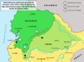
Map of the disputed territories from 1916 onwards
-
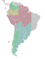
Territorial divisions of the Viceroyalty of Peru as described by the laws compiled in the Recopilación of 1680.
-
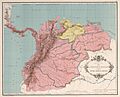
The Viceroyalty of New Granada as laid out in the Royal Decree of 1717.
-
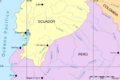
Ecuador-Perú border
-
Map of a Peruvian school in Callao showing the territories claimed by Peru in 1937.

