
Edgartown, Massachusetts facts for kids
Quick facts for kids
Edgartown
|
||
|---|---|---|
| Town of Edgartown | ||

Edgartown Harbor, with the Edgartown Memorial Wharf (center)
|
||
|
||

Location in Dukes County in Massachusetts
|
||

Edgartown
Location in Massachusetts

Edgartown
Location in the United States
|
||
| Country | United States | |
| State | Massachusetts | |
| County | Dukes | |
| Settled | 1642 | |
| Incorporated | July 8, 1671 | |
| Government | ||
| • Type | Open town meeting | |
| Area | ||
| • Total | 122.7 sq mi (317.9 km2) | |
| • Land | 27.0 sq mi (69.9 km2) | |
| • Water | 95.8 sq mi (248.0 km2) | |
| Elevation | 17 ft (5 m) | |
| Population
(2020)
|
||
| • Total | 5,168 | |
| • Density | 191.4/sq mi (73.9/km2) | |
| Time zone | UTC−5 (Eastern) | |
| • Summer (DST) | UTC−4 (Eastern) | |
| ZIP Code |
02539
|
|
| Area code(s) | 508/774 | |
| FIPS code | 25-21150 | |
| GNIS feature ID | 0619441 | |
| Website | www.edgartown-ma.us | |

Edgartown is a town located on Martha's Vineyard island in Dukes County, Massachusetts, United States. It's the main town for the county. In 2020, about 5,168 people lived there.
Long ago, Edgartown was a very important port for whaling ships. Many old houses from that time are still standing and have been kept in great condition. Today, the town is famous for its beautiful harbor, where many yachts gather for sailing events. Edgartown also includes Chappaquiddick Island, which is a small piece of land connected by a short ferry ride.
Contents
History of Edgartown
In 1642, a group of families, led by Reverend Thomas Mayhew, Jr., came to the island to start a new settlement. His father, Thomas Mayhew, had bought the island. At first, they called the area Great Harbor.
The town officially became Edgar Towne on July 8, 1671. It was named after Edgar, whose father, James II of England, was next in line to become the King of England. However, the people who chose the name didn't know that Edgar had sadly passed away at age three, just a month before the town was named. Edgartown was one of the first two towns on Martha's Vineyard, along with Tisbury.
Reverend Mayhew, Jr. also worked with a Wampanoag Native American named Hiacoomes. Together, they helped set up churches in the Native American communities nearby.
Whaling and Its Decline
During the 1800s, Edgartown was a major center for the whaling industry. Ships from all over the world would come to its safe harbor. Whaling captains often built large, fancy houses for their families. These houses sometimes had small rooms on the top floor called widow's walks.
People used to think that wives would stand in these rooms for months, watching for their husbands' ships to return from the sea. However, there's not much proof that these rooms were used for that. They were often built near the chimney so people could easily get to it. This helped them pour sand down the chimney if there was a chimney fire, to stop the house from burning down.
As new ways of getting oil became available, the whaling industry slowly faded away. By the early 1900s, whaling was no longer important to Edgartown's economy. Today, the town is mostly known for tourism. It's also the location of Chappaquiddick, which is famous for an event that happened there in 1969.
Tourism in Edgartown
Edgartown is a popular place for summer vacations and tourists. Many of the beautiful old houses built by whaling captains and other important people centuries ago are still here. Over the last 25 years, many of these historic homes have been carefully restored.
Along Water Street, near the harbor, you can see many of these "Captain's Homes." The town has worked hard to encourage the repair of old buildings. For example, the Whaling Church, a large church from the 1700s, is now a place for concerts and shows. The Daniel Fisher House next door is used for different social events. Edgartown is also easy to explore on foot or by bike, which makes it even more appealing to visitors.
Filming Location and Beaches
Edgartown was the main filming location for the town of Amity in Steven Spielberg's famous 1975 movie Jaws. Many of the places and buildings you see in the movie can still be found in Edgartown today.

The Edgartown Harbor Light is a lighthouse at the end of North Water Street. It marks the entrance to the harbor. The harbor itself is very large and can hold many small and large boats.
Another popular spot is South Beach. This is a part of the ocean beach that stretches along the southern side of the island. You can get there by driving or taking a bus about 2.5 miles south from Edgartown center. South Beach is known for its crashing ocean waves and is a big draw for tourists. Much of the beach in Edgartown is open to everyone, and there's plenty of parking. The part of the beach near Katama can get busy, but other sections further west are often quieter.
Geography of Edgartown

Edgartown covers a total area of about 122.7 square miles (317.9 square kilometers). Most of this area, about 95.8 square miles (248.0 square kilometers), is water. The land area is about 27.0 square miles (69.9 square kilometers). This makes Edgartown the largest town by land area in Dukes County.
Edgartown is located on the eastern side of Martha's Vineyard. People on the island sometimes call this area "down-island." This comes from an old sailing term where traveling east was called "down east."

The town also includes the smaller Chappaquiddick Island. Sometimes, Chappaquiddick is connected to Martha's Vineyard by a sandbar. But during storms, this connection can break. Chappaquiddick is separated from the main town center by Edgartown Harbor and Katama Bay.
Katama is a southern part of Edgartown. It has a beach, the Katama Airpark (a small airport with a grass runway), and two farms. Edgartown is also home to half of the Manuel F. Correllus State Forest. There are nine beaches, a yacht club, and several nature preserves in the town. These include the Wasque Reservation and the Cape Pogue Wildlife Refuge on Chappaquiddick. Edgartown has two lighthouses: the Cape Pogue Light on Chappaquiddick and the Edgartown Harbor Light in Edgartown Harbor.
Climate

Edgartown has a humid subtropical climate. This means it has mild winters with some snow and hot, humid summers. The weather here is a bit like places further south, but it's one of the most northern spots in North America with this type of climate.
The temperature changes less between day and night in Edgartown compared to the mainland. Even though winter temperatures are generally mild, Edgartown can still get very cold when winds blow from the cold interior of the country.
Transportation


To get cars to Chappaquiddick Island, there are two ferries called the "On Time II" and "On Time III." There's a common story that the original ferry, "On Time," was named because it never had a schedule, so it was never late. But the real reason is that a new owner had less than two weeks to build the ferry before he took over the service in 1948. The crew worked very hard and launched the new ferry "on time."
The "On Time II" was built in 1969, and the "On Time III" was built in 1975. Both are still used today.
Besides the On Time ferries, Edgartown also has another ferry called the Pied Piper. This ferry runs during certain seasons between Edgartown and Falmouth, which is on Cape Cod.
There are two airports in the town. Katama Airpark is a small airport with a grass runway. It's used by smaller private planes. The Martha's Vineyard Airport is shared with the nearby town of West Tisbury. This airport is used for flights that connect the island to the mainland and Nantucket.
Education
Edgartown is part of the Martha's Vineyard Regional School District. This district also includes students from Aquinnah, Chilmark, Oak Bluffs, Tisbury, and West Tisbury.
Students in Edgartown go to Edgartown Elementary School for kindergarten through 8th grade. After that, they attend Martha's Vineyard Regional High School. The high school sports teams are called the Vineyarders, and their colors are violet and white. The school has a long-standing sports rivalry with Nantucket High School, and they play each other every year for the Island Cup.
Notable people
Many interesting people have lived in or are connected to Edgartown:
- Ruth Gordon, an actress
- Helen Jernegan, a whaling captain's wife who traveled the world
- Patricia Neal, a famous actress
- Barack Obama, former U.S. President
- Michelle Obama, former First Lady of the U.S.
- Enid Yandell, a sculptor
Images for kids
-
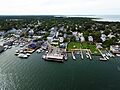
Edgartown Harbor, with the Edgartown Memorial Wharf (center)
-
Seal of Edgartown, Massachusetts
-
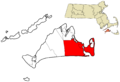
Location in Dukes County in Massachusetts
See also
 In Spanish: Edgartown para niños
