
Etah facts for kids
Quick facts for kids
Etah
|
|
|---|---|
|
City
|
|

Etah
Location in Uttar Pradesh
|
|
| Country | |
| State | Uttar Pradesh |
| District | Etah |
| Founded by | King Dil sukh Rai bhadur |
| Government | |
| • Type | Municipal Corporation |
| • Body | Etah Municipal Corporation |
| Population
(2011)
|
|
| • Total | 131,023 |
| Languages | |
| • Official | Hindi |
| Time zone | UTC+5:30 (IST) |
| Vehicle registration | UP-82 |
Etah is a city in the Uttar Pradesh state of India. It is the main city and headquarters of the Etah District. Etah is part of the Aligarh Division.
The city is located in the middle of the Delhi-Kanpur Highway (NH 91). This highway is also known as GT Road. The big cities closest to Etah are Aligarh and Agra. In 2011, Etah had a population of about 131,023 people.
Contents
History of Etah
Ancient Times and Early Rulers
Etah is located in the cultural area called Braj. Long ago, during the Vedic Age, it was part of a large kingdom called Surasena Mahajanapada. Over time, different powerful kingdoms ruled Etah. These included the Mauryas, Guptas, Scythians, Kushans, and Indo-Greeks. After them, local Rajput rulers took control.
How Etah Got Its Name
In old times, Etah was called "Aintha." This word means 'to respond aggressively.' People say this name came from a story about the King of Awagarh. He was hunting in the forest with his two dogs. His dogs chased a fox, but when the fox reached the area of Etah, it suddenly turned around. The fox bravely faced the dogs and acted very aggressively.
The King was surprised by this change in the fox's behavior. He thought this place must have something special that made the fox so brave. So, he named the place "Aintha." Later, people started saying "Etah" instead.
Another story says the old name was "Einta." This means 'brick' in Hindi. The story tells of a person who was lost and looking for water. When he dug into the ground, his shoe hit a brick. This led to the name "Einta," which then became "Etah."
Etah's Role in Indian History
Etah is important because it is located halfway on the Kanpur-Delhi Highway. It is also known for its role in the Indian Rebellion of 1857. This was a major uprising against British rule in India.
Geography of Etah
Etah is located at coordinates 27.63° N latitude and 78.67° E longitude. The city is about 170 meters (557 feet) above sea level. Two important canals, the upper and lower Ganga Canal, flow through Etah. These canals help provide water to the region.
People and Culture
Population and Languages
According to the 2011 census, Etah's urban area had a population of 131,023 people. There were 69,446 males and 61,577 females. Most people in Etah can read and write, with a literacy rate of 85.62%.
The main local languages spoken in Etah are Brajbhasha and Kannauji.
| Religions in Etah | ||||
|---|---|---|---|---|
| Religion | Percent | |||
| Hindus | 78.30% | |||
| Muslims | 17.92% | |||
| Jains | 2.80% | |||
| Others† | 0.6% | |||
| Distribution of religions †Includes Sikhs (0.2%), Buddhists (<0.2%). |
||||
Cultural Activities
Etah is part of the Braj cultural region. It has been an important district headquarters since the time of British rule. A large open field called Padav Maidan is used for different events. Every year, the Ramlila festival is held here in September and October. This field also hosts exhibitions from December to February.
Amir Khusro, a famous poet, was born in Patiyali, Kasganj. He is known as one of the best poets of the Urdu language.
Traditional Dress
People in Etah wear many different styles of clothes, both traditional and Western. Traditional clothes include colorful draped garments like the sari for women. Men often wear a dhoti or lungi. Tailored clothes like shalwar kameez and kurta-pyjama are also common.
Men sometimes wear head coverings like a topi or pagri. A Sherwani is a more formal outfit for men. It is often worn with chooridar pants for special events. Western-style trousers and shirts are also popular.
Local Food
The food in Etah is similar to the cuisine found in the rest of Uttar Pradesh. It includes both vegetarian and non-vegetarian dishes. Some popular foods are dum biryani, kababs, and kormas.
Civic Services and Development
City Planning and Utilities
The city of Etah has a master plan that guides its development. The U.P. Jal Nigam is in charge of providing water supply to the city. Electricity is supplied by Dakshinanchal Vidyut Vitran Nigam Ltd.
Power Project
A large thermal power project is planned near Malawan, about 15 kilometers from Etah. This project will produce 1320 megawatts of electricity. The land needed for the project has been bought, and construction is expected to be finished in 2021.
Transportation in Etah
Railway Connections
The railway line in Etah was opened in 1959 by India's first president, Rajendra Prasad. Trains run from Etah to Tundla. A special train, the Etah–Agra Fort Passenger Special, also connects Etah to Agra. There are plans for direct trains to New Delhi, Agra, and Aligarh.
Religious Places
Etah is home to several important religious sites. The Dargah Hazrat Makhdoom Abdul Ghafur Shah Safvi is a holy place for Sufi Muslims. Hazrat was a great Sufi saint.
The Kailash Mandir is a Hindu temple that is 148 years old. It was built by King Dil Sukh Rai Bahadur. The village of Noah Kera is known as the place where Lord Sri Krishna married Rukmini. Bhooteshwar is a place where Hindu ceremonies take place.
Economy of Etah
The main sources of income in Etah are agriculture and industry.
Agriculture
Agriculture is the most important part of Etah's economy. The area is located between the Ganga and Yamuna rivers, which makes the soil very fertile. This type of soil is called Alluvial soil. Farmers can grow three crops each year because there is water for irrigation all year round.
The main crops grown in Etah are rice, wheat, barley, jowar, bajra, and maize. The soil is also good for growing tobacco.
Images for kids
-
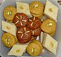
Assorted halva including sooji, chana, and gajar halva
-
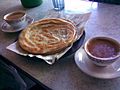
Paratha served with tea
-
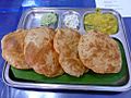
Puri with accompaniments
-
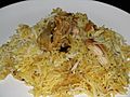
Chicken Dum Biryani
-
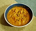
Navratan korma
-
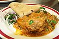
Chicken curry with chapati


See also
 In Spanish: Etah para niños
