Extreme points of Ireland facts for kids
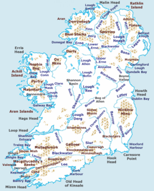
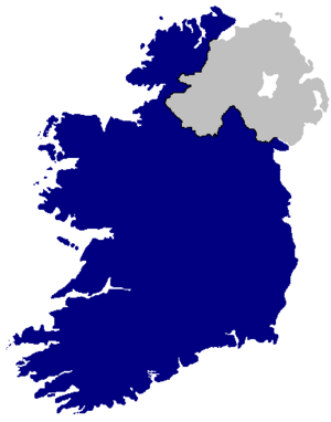
Ireland is an island with many interesting places! This article tells you about the extreme points of Ireland. These are the places that are the farthest north, south, east, or west on the island. It includes both the Republic of Ireland and Northern Ireland.
People often say "Malin to Mizen" to talk about the whole island, from its very north to its very south. The exact middle of Ireland is about 8.85 kilometers (5.5 miles) north-northwest of Athlone Town.
Contents
All of Ireland: Farthest Spots
Let's look at the very edges of the whole island of Ireland, including all its smaller islands.
Farthest Points (Including Islands)
These are the absolute farthest points of land:
- Northernmost point: Tor Beg rock near Inishtrahull, in County Donegal, which is in the Republic of Ireland.
- Southernmost point: Fastnet Rock southeast of Cape Clear Island, in County Cork, Republic of Ireland.
- Westernmost point: Tearaght Island, in County Kerry, Republic of Ireland.
- Easternmost point: Cannon Rock, in County Down, which is in Northern Ireland.
Farthest Towns and Villages (Including Islands)
These are the towns or villages closest to the extreme points:
- Northernmost settlement: Ballyhillin, on the Inishowen Peninsula, County Donegal.
- Southernmost settlement: Clear Island, County Cork.
- Westernmost settlement: Dunquin, on the Dingle Peninsula, County Kerry.
- Easternmost settlement: Portavogie, on the Ards Peninsula, County Down (Northern Ireland).
Farthest Points on the Mainland Only
Now, let's look at the extreme points if we only consider the main island, not the smaller islands around it.
- Northernmost point: Banba's Crown (the very tip of Malin Head), on the Inishowen Peninsula, County Donegal, Republic of Ireland.
- Southernmost point: Brow Head (close to Mizen Head), County Cork, Republic of Ireland.
- Westernmost point: Dunmore Head, on the Dingle Peninsula, County Kerry, Republic of Ireland.
- Easternmost point: Burr Point, on the Ards Peninsula, County Down, Northern Ireland.
Farthest Towns and Villages on the Mainland Only
- Northernmost settlement: Ballyhillin, on the Inishowen Peninsula, County Donegal, Republic of Ireland.
- Southernmost settlement: Crookhaven, County Cork, Republic of Ireland.
- Westernmost settlement: Dunquin, on the Dingle Peninsula, County Kerry, Republic of Ireland.
- Easternmost settlement: Portavogie, on the Ards Peninsula, County Down, Northern Ireland.
Highest and Lowest Spots
- Highest point: Carrauntoohil, in County Kerry, Republic of Ireland. It's 1,041 meters (3,466 feet) tall!
- Highest settlement: Meelin, County Cork, Republic of Ireland. It's 254 meters (832 feet) above sea level.
- Lowest point: North Slob, County Wexford, Republic of Ireland. This area is actually 3 meters (10 feet) below sea level!
Even though some places are very low, there are no natural dry areas of land below sea level in Ireland. This is because of all the rain!
Republic of Ireland: Farthest Spots
Here are the extreme points just for the Republic of Ireland.
Farthest Points (Including Islands)
- Northernmost point: Inishtrahull, County Donegal.
- Northernmost settlement: Ballyhillin, Inishowen Peninsula, County Donegal.
- Southernmost point: Fastnet Rock, County Cork.
- Southernmost settlement: Crookhaven, County Cork.
- Westernmost point: Tearaght Island, County Kerry.
- Westernmost settlement: Dunquin, Dingle Peninsula, County Kerry.
- Easternmost point: Lambay Island, County Dublin.
- Easternmost settlement: Wicklow, County Wicklow.
Farthest Points on the Mainland Only
- Northernmost point: Banba's Crown (the tip of Malin Head), Inishowen Peninsula, County Donegal.
- Northernmost settlement: Ballyhillin, Inishowen Peninsula, County Donegal.
- Southernmost point: Brow Head (near Mizen Head), County Cork.
- Southernmost settlement: Crookhaven, County Cork.
- Westernmost point: Dunmore Head, Dingle Peninsula, County Kerry.
- Westernmost settlement: Dunquin, County Kerry.
- Easternmost point: Wicklow Head, County Wicklow.
- Easternmost settlement: Wicklow, County Wicklow.
Highest and Lowest Spots
- Highest point: Carrauntoohil, County Kerry.
- Lowest point: North Slob, County Wexford.
- Highest settlement: Meelin, County Cork.
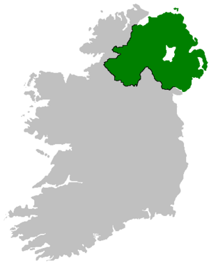
Northern Ireland: Farthest Spots
Now let's look at the extreme points for Northern Ireland.
Farthest Points (Including Islands)
- Northernmost point: Skerriagh, Ballygill North, on Rathlin Island.
- Northernmost settlement: Rathlin Island, County Antrim.
- Southernmost point: Cranfield Point, County Down.
- Southernmost settlement: Greencastle, County Down.
- Westernmost point: The western part of Manger townland, County Fermanagh.
- Westernmost settlement: Belleek, County Fermanagh.
- Easternmost point: Canon Rock, County Down.
- Easternmost settlement: Portavogie, County Down.
Farthest Points on the Mainland Only
- Northernmost point: Benbane Head, County Antrim.
- Northernmost settlement: Ballintoy, County Antrim.
- Southernmost point: Cranfield Point, County Down.
- Southernmost settlement: Greencastle, County Down.
- Westernmost point: The western part of Manger townland, County Fermanagh.
- Westernmost settlement: Belleek, County Fermanagh.
- Easternmost point: Burr Point, Ards Peninsula, County Down.
- Easternmost settlement: Portavogie, County Down.
Highest Spot
- Highest point: Slieve Donard, County Down. It is 850 meters (2,789 feet) high.
- Highest settlement: Greencastle, County Tyrone. It is 188 meters (617 feet) above sea level.
 | Delilah Pierce |
 | Gordon Parks |
 | Augusta Savage |
 | Charles Ethan Porter |


