Fort Assiniboine facts for kids
Quick facts for kids
Fort Assiniboine
|
|
|---|---|
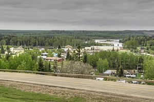
Skyline and the Athabasca River
|
|
| Country | Canada |
| Province | Alberta |
| Region | Northern Alberta |
| Planning region | Upper Athabasca |
| Municipal district | Woodlands |
| Government | |
| • Type | Unincorporated |
| Area
(2021)
|
|
| • Land | 0.75 km2 (0.29 sq mi) |
| Population
(2021)
|
|
| • Total | 158 |
| • Density | 212/km2 (550/sq mi) |
| Time zone | UTC−7 (MST) |
| • Summer (DST) | UTC−6 (MDT) |
| Fort Assiniboine | |
|---|---|
| Type | Fort |
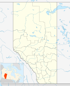
| Location | Barrhead, Alberta, Canada |
| Nearest city | Edmonton |
| Elevation | 604 m (1,982 ft) |
| Governing body | Woodlands County Council |
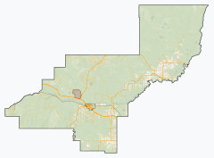
Fort Assiniboine is a small community called a hamlet in northwest Alberta, Canada. It is part of Woodlands County. You can find it on the north side of the Athabasca River. It is located where Highway 33 and Highway 661 meet.
This hamlet is about 39 kilometers (24 miles) northwest of Barrhead. It is also 62 kilometers (39 miles) southeast of Swan Hills. Fort Assiniboine is named after the Assiniboine people.
The original fort was a trading post built by the Hudson's Bay Company. It became an important stop on the Klondike Trail. The old fort no longer stands, but the land is a National Historic Site. This means it is protected for its history. Today, the hamlet is a local center for farming.
Contents
The Story of Fort Assiniboine
Local stories say there was an early fur trading post here. It might have been built by the North West Company in the late 1700s. In 1821, the North West Company joined with the Hudson's Bay Company (HBC). The HBC wanted to make their travel routes better.
Building the Trading Post
In 1823, the HBC decided to build a new fort. This fort would be further up the Athabasca River. It would help them move goods faster. The fort was first called 'Athabaska River House'. It opened in 1824.
The Hudson's Bay Packtrail
This new fort became the end point of an 80-mile horse trail. This trail went to Edmonton House (now Fort Edmonton). Jacques Cardinal, a Métis trader, cut this trail in 1824–25. It became known as 'The Hudson's Bay Packtrail'.
The trail made travel shorter from the Rocky Mountains to Fort Edmonton. From there, goods went to York Factory on the Hudson Bay. People on horseback could travel from Edmonton to Fort Assiniboine in two to six days. This depended on the weather and trail conditions.
The new route was used by the York Factory Express. The old route was much longer. It involved canoes going far north to Fort Chipepewyan. Then they went southeast through Methye Portage to Lake Winnipeg.
The Fort's Importance and End
Fort Assiniboine was never as big as other forts in Alberta. But it was very important for transportation and supplies. This helped it survive from the 1820s to the 1880s.
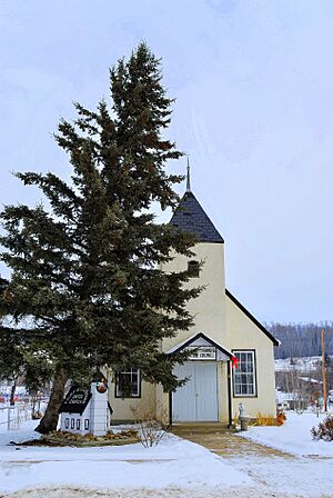
The original fort burned down after the HBC left it. There were no original drawings of the fort. But clues from old log books and digs helped build a copy in 1980. This copy now works as a museum and community center.
Gold Rush and New Settlers
In 1898, the Klondike Trail was created. This trail went through the Swan Hills to Lesser Slave Lake. Fort Assiniboine became a stopping point again. Gold seekers used a self-service ferry to cross the river. They were on their way to the Yukon to find gold.
The first homes in the area were built in 1906. This was in the Holmes Crossing area. Most settlers came from Edmonton using the Hudson's Bay Pack Trail. This trail was wide enough for wagons by then.
By 1908, more settlers crossed the river by ferry. They built homes north of the Athabasca River. This included the area around the old fort. The Fort Assiniboine post office opened in 1910. A blacksmith shop and a store were built nearby. In 1914, a railway was built to Westlock. This made the trail much shorter.
Growth of the Community
The first community hall was built in 1916. By 1919, the road to Holmes Crossing was improved. In 1922, the post office moved into the settlement. The land where the trading post stood was owned by Dr. E.J. State. When he passed away in 1923, he left his land to the University of Alberta. The university then sold lots, which helped the hamlet grow.
In 1927, a railway line was built to Barrhead, about 40 kilometers (25 miles) away.
In 1934, the government started a public nursing service in the hamlet. This helped people with their health until 1969. In 1946, all the local schools joined together in Fort Assiniboine. Also in 1946, a local branch of the Royal Canadian Legion was started. A United Church and a Roman Catholic Church were built in 1948 and 1949.
A curling club was formed in 1953, and a rink was built. In 1956, a bridge was built over the Athabasca River. This meant the ferry was no longer needed.
From Village to Hamlet
Fort Assiniboine became a village in 1958. E.M. (Gene) Redington was the first mayor. However, the Village of Fort Assiniboine changed back to a hamlet on December 31, 1991. Now, Woodlands County manages the hamlet. Woodlands County has offices in Fort Assiniboine and in Whitecourt.
Population Facts
In 2021, Fort Assiniboine had a population of 158 people. These people lived in 64 homes. This was a small decrease from 176 people in 2016. The hamlet covers an area of 0.75 square kilometers (0.29 square miles).
Fun Things to See and Do
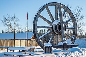
Fort Assiniboine has a museum that looks like a Hudson's Bay trading post. It is called the Fort Assiniboine Museum and Friendship Club Drop-In Centre. You can also see the world's largest wagon wheel and pick axe here!
East of the hamlet, there is a boat launch. This lets people with boats get onto the Athabasca River. There is also a private R.V. park and marina. In June 2017, this park hosted the Athabasca River Voyageur Canoe Brigade. This event celebrated Canada's 150th birthday.
A farmer's market is held every Friday afternoon. It runs from May to September. You can find it in the Recreation and Agriculture Building. This building also hosts farm and sports events all year. One big event is the annual Hamlet Hoedown Rodeo & Fair, held every August.
Community Services
The Fort Assiniboine School teaches students from Kindergarten to Grade 9. It is located right in the hamlet. Older students (Grades 10-12) take a bus to Barrhead Composite High School. Both schools are part of Pembina Hills Public Schools.
Fort Assiniboine also has a post office and the Fort Assiniboine Public Library. You can find many businesses here. These include a general store, a motel, a gas station, and a liquor store. There is also a shop that fixes and sells all-terrain vehicles and other vehicles.
Weather and Climate
Fort Assiniboine has a subarctic climate. This means it has nice summers. The winters are very cold, but the temperature can change a lot.
| Climate data for Fort Assiniboine | |||||||||||||
|---|---|---|---|---|---|---|---|---|---|---|---|---|---|
| Month | Jan | Feb | Mar | Apr | May | Jun | Jul | Aug | Sep | Oct | Nov | Dec | Year |
| Record high °C (°F) | 13.0 (55.4) |
17.0 (62.6) |
17.0 (62.6) |
29.5 (85.1) |
34.0 (93.2) |
33.3 (91.9) |
32.0 (89.6) |
33.0 (91.4) |
33.0 (91.4) |
29.0 (84.2) |
18.5 (65.3) |
13.3 (55.9) |
34.0 (93.2) |
| Mean daily maximum °C (°F) | −8.2 (17.2) |
−3.3 (26.1) |
2.9 (37.2) |
11.3 (52.3) |
17.5 (63.5) |
20.7 (69.3) |
22.5 (72.5) |
21.4 (70.5) |
16.1 (61.0) |
10.4 (50.7) |
−1.1 (30.0) |
−7.7 (18.1) |
8.5 (47.3) |
| Daily mean °C (°F) | −14.8 (5.4) |
−10.8 (12.6) |
−4.2 (24.4) |
3.7 (38.7) |
9.7 (49.5) |
13.5 (56.3) |
15.6 (60.1) |
14.4 (57.9) |
9.1 (48.4) |
3.4 (38.1) |
−6.7 (19.9) |
−13.9 (7.0) |
1.6 (34.9) |
| Mean daily minimum °C (°F) | −21.4 (−6.5) |
−18.2 (−0.8) |
−11.3 (11.7) |
−3.9 (25.0) |
1.9 (35.4) |
6.3 (43.3) |
8.6 (47.5) |
7.4 (45.3) |
2.1 (35.8) |
−3.5 (25.7) |
−12.3 (9.9) |
−20 (−4) |
−5.4 (22.3) |
| Record low °C (°F) | −48 (−54) |
−47 (−53) |
−38.9 (−38.0) |
−30 (−22) |
−8.5 (16.7) |
−2.8 (27.0) |
1.7 (35.1) |
−4 (25) |
−11 (12) |
−30 (−22) |
−38.3 (−36.9) |
−46 (−51) |
−48 (−54) |
| Average precipitation mm (inches) | 18.6 (0.73) |
15.5 (0.61) |
16.1 (0.63) |
24.0 (0.94) |
48.9 (1.93) |
105.3 (4.15) |
118.7 (4.67) |
83.2 (3.28) |
44.0 (1.73) |
16.9 (0.67) |
18.6 (0.73) |
23.4 (0.92) |
533.2 (20.99) |
| Source: Environment Canada | |||||||||||||
 | Valerie Thomas |
 | Frederick McKinley Jones |
 | George Edward Alcorn Jr. |
 | Thomas Mensah |


