Westlock facts for kids
Quick facts for kids
Westlock
|
|||
|---|---|---|---|
|
Town
|
|||
| Town of Westlock | |||
|
|||

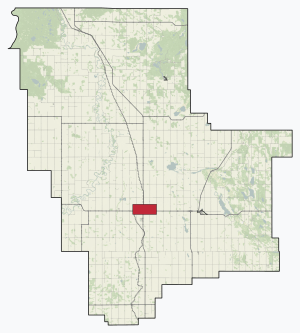
Location in Westlock County
|
|||
| Country | Canada | ||
| Province | Alberta | ||
| Planning region | Upper Athabasca | ||
| Municipal district | Westlock County | ||
| Incorporated | |||
| • Village | March 13, 1916 | ||
| • Town | January 7, 1947 | ||
| Area
(2021)
|
|||
| • Land | 13.37 km2 (5.16 sq mi) | ||
| Elevation | 648 m (2,126 ft) | ||
| Population
(2021)
|
|||
| • Total | 4,921 | ||
| • Density | 368/km2 (950/sq mi) | ||
| Time zone | UTC−7 (MST) | ||
| • Summer (DST) | UTC−6 (MDT) | ||
| Forward sortation area |
T7P
|
||
| Area code(s) | +1-780 | ||
| Highways | 18, 44 | ||
| Website | westlock.ca | ||
Westlock is a town located in the middle of Alberta, Canada. It was started in 1913. This town is a main hub for farming, businesses, and local government services. It helps many smaller communities and farms in the area called Westlock County.
Contents
Westlock's Location and Environment
Westlock is about 85 kilometers (53 miles) north of Edmonton. Edmonton is Alberta's capital city. Westlock is found where two main roads, Highway 44 and Highway 18, meet. It is surrounded by Westlock County.
Land and Climate in Westlock
Westlock sits on the Alberta plain, which is part of the Great Plains. It is just north of the area where water flows either to the Athabasca River or the North Saskatchewan River. The town is about 670 meters (2,200 feet) above sea level.
Westlock has a humid continental climate. This means it has warm summers and cold winters. It is on the northern edge of the aspen parkland belt. This area used to have many trees but was cleared for farming. The soil here is dark and good for growing crops. To the north, the climate becomes much colder, like a subarctic climate.
The average yearly rainfall in the area is 468 millimeters (18.4 inches). The average yearly temperature is 1.9 °C (35.4 °F). In July, the average temperature reaches 16.8 °C (62.2 °F). In January, it drops to -11.4 °C (11.5 °F).
Westlock's Past: A Look Back
Before European settlers arrived, Indigenous people, especially the Cree, lived in the Westlock area. The fur trade was active in Alberta since 1754. However, the Westlock area was first written about in 1799 by David Thompson.
Early Settlements and Changes
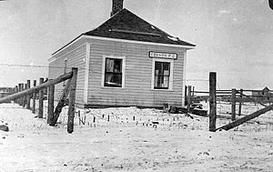
White settlers began to arrive in 1902. The first community was about 5 kilometers (3 miles) east of where Westlock is today. It was founded by the Edgson family. But the name was hard to say, and another town called Edson, Alberta already existed. So, they named the site Edison, after the inventor Thomas Edison.
By 1912, Edison was a small community. It had only about 13 buildings, including shops, homes, and two churches. There was also a post office, but it closed in 1911.
In 1911, a railway reached Clyde to the east. In 1912, a new railway company planned a new townsite where Westlock is now. This new site was to the west of Edison. Edison was then stuck between two railway lines. In 1914, the Methodist church building from Edison was moved to Westlock. This showed that the new settlement was becoming more important.
How Westlock Got Its Name and Grew
The name Westlock comes from two people: William Westgate and William Lockhart. They owned the land where the town was built. Westlock officially became a village on March 16, 1916. It had 65 residents. George MacTavish was the first leader, called a reeve. That same year, the first grain elevator was built. This was a tall building used to store grain.
The first bank branch, the Merchant's Bank, opened in 1918. A permanent brick school was built in 1925. In 1927, the Sisters of Charity of Saint Vincent de Paul started a hospital in an old house. A new, special hospital called the Immaculata opened in 1928. Westlock became a town on January 7, 1947, with 854 people. The Memorial Hall was also built that year.
In 1992, the Memorial Hall burned down but was later rebuilt. In 1995, a new hospital, the Westlock Health Care Centre, replaced the old one. The old hospital was taken down in 1997.
In 2024, Westlock residents voted on a local rule. This rule limits the types of flags that can be flown on town property. It also limits the colors of crosswalks to only white. The Mayor, Jon Kramer, and other leaders said this rule was binding. However, they also said the town would keep supporting all community members, including those from diverse groups.
Westlock's Population Over Time
|
||||||||||||||||||||||||
In 2021, Statistics Canada counted 4,921 people living in Westlock. These people lived in 2,151 homes. This was a small decrease from 5,101 people in 2016. The town covers 13.37 square kilometers (5.16 square miles). This means there were about 368 people per square kilometer in 2021.
In 2016, Westlock had 5,101 people. This was a small increase from 4,823 people in 2011. The town's population density was about 381 people per square kilometer in 2016.
The town's own count in 2015 showed 5,147 people. This was an increase from 4,964 people in 2008.
Homes and Families in Westlock
In 2006, Westlock had 2,060 homes where people lived. Most of these homes (74.8%) were single-family houses. About 17.7% were apartments in smaller buildings.
Many homes (1,410) were owned by the people living in them. About 650 homes were rented. Most of the homes (1,630) were built before 1986. The average value of owned homes was $148,083.
There were 2,060 households in 2006. Of these, 1,355 were families. The average family had 2.8 people. The average income for a household in 2005 was $41,487. For families, it was $47,853.
Languages and Backgrounds
In 2006, most people (3,945) in Westlock spoke English as their first language. A smaller number (125) spoke French. Some (600) spoke another language. Almost everyone in town could speak English.
Only 385 people in Westlock were immigrants. Most of them (300) came to Canada before 1991. Almost everyone (all but 55 people) was a Canadian citizen. Most Canadian-born residents had families who had lived in Canada for three or more generations.
Most people (3,980) had lived in the same house for at least a year. Many (2,525) had lived in the same house for five years or more.
There were 310 people who identified as Aboriginal. There were 145 people who reported being visible minorities.
Education and Jobs
In 2006, many adults (1,385 out of 3,825 people aged 15 and older) did not have a certificate, diploma, or degree. However, 1,100 adults had a high school certificate or similar.
The total number of people working was 2,155. The most common jobs were in sales and service (660 people). Other common jobs were in trades, transport, and equipment operation (410 people). The main types of businesses were other services (360 people), health care (355 people), and retail stores (320 people).
Most people worked in Westlock itself. Only 255 people worked in another town. Most people (1,485) who had a regular workplace drove to work in their own car.
In 2005, about 11% of adults in Westlock had low incomes before taxes. For those under 18, the rate was 10.4%.
Westlock's Economy and Jobs
The area around Westlock is mostly about farming. There is also some oil and gas activity. The main employers in town include hotels that serve oil workers. There are also farm equipment dealerships. Some small factories, like Wabash Mfg. Inc. (which makes custom products) and a Lafarge cement plant, also provide jobs.
Westlock is still a center for the grain trade. Trains still carry grain from the remaining grain elevators. These are now owned by a local company called Westlock Terminals. Westlock is also a government center. It has the Westlock County office, public and Catholic schools, a courthouse, a public library, and a modern hospital.
Because of this, Westlock is the main town in the region. Rural families come here for business, send their children to school, and get government services. Many older people from the countryside also move to Westlock when they retire. There are several retirement homes in town.
Westlock is too far from Edmonton to be a "bedroom community" where many people live and commute to Edmonton for work. However, some people do commute. Since World War II, highway traffic going to oil fields in Northern Alberta has become very important to the town.
New stores and businesses have moved from the old downtown area (which was near the railway) to larger malls and businesses along the highway. There was a plan for homes near the Westlock Airport. This would allow people to fly to work at the oilsand projects in Fort McMurray and other northern areas. However, this plan has not started yet.
Media in Westlock
- Newspaper: Westlock News (started as Westlock Witness in 1919)
- FM Radio: Real Country 97.9 (FM 97.9, CKWB-FM) plays country music. It is owned by Stingray Radio.
Education in Westlock
The schools in Westlock are part of the Pembina Hills Public Schools district. This district was formed in 1995 when three school districts joined together.
Famous People from Westlock
- W.A.C. Bennett, a former leader of British Columbia
- Rollie Boutin, a retired professional hockey player
- David Chatters, a former member of the Canadian Parliament
- Kyle Chipchura, a professional hockey player
- Herbert Greenfield, a former leader of Alberta
- Carolyn Dawn Johnson, a country music singer
- Greg Polis, a retired professional hockey player
- Colleen Soetaert, a Canadian politician
- Claudette Tardif, a former Deputy Leader in the Senate of Canada
- Dale C. Thomson, an academic and advisor to the Prime Minister
- Simeon Rottier, a professional football player
 | Jackie Robinson |
 | Jack Johnson |
 | Althea Gibson |
 | Arthur Ashe |
 | Muhammad Ali |


