
Galician Massif facts for kids
Quick facts for kids Galician Massif |
|
|---|---|
| Macizo Galaico Macizo Galaico-Leonés |
|
 |
|
| Highest point | |
| Peak | Peña Trevinca |
| Elevation | 2,124 m (6,969 ft) |
| Geography | |

Topographic map of Galicia
|
|
| Country | Spain |
| Range coordinates | 42°30′N 8°6′W / 42.500°N 8.100°W |
| Geology | |
| Orogeny | Variscan orogeny |
| Age of rock | Paleozoic |
| Type of rock | Schist, gneiss and granite |
The Galician Massif (also called Macizo Galaico or Macizo Galaico-Leonés) is a group of mountain ranges. You can find it in the northwestern part of the Iberian Peninsula, which is where Spain and Portugal are. Most of it is in Galicia, a region in Spain. Some parts also stretch into the Zamora and León areas of Castile and León.
The tallest point in the Galician Massif is Pena Trevinca, which stands at 2,127 meters (about 6,978 feet) high. Another important peak is Cabeza de Manzaneda, reaching 1,781 meters (about 5,843 feet).
In local stories from Galicia, people say that the forests of the Galician Massif are home to many magical creatures. These include elves, fairies, and even ghosts. There are also tales of the Santa Compaña, the Nubeiro (a cloud spirit), and witches, known as meigas.
Contents
Understanding the Geology of the Galician Massif
The Galician Massif is like an extension of the Meseta Central, which is the big flat plateau in the middle of Spain. Its rocks and landforms are very similar to those in the Tras os Montes region of Portugal. Because of this, geologists often study them together as the 'Galicia-Trás-os-Montes Zone'.
The mountains are made mostly of very old rocks from the Paleozoic Era. These include granite, which is a hard igneous rock, and metamorphic rocks like gneiss, slate, and schist. Metamorphic rocks are rocks that have changed due to heat and pressure. These rocks were later shaped by a process called Alpine folding, which means they were bent and folded by powerful forces in the Earth. The eastern part of the massif connects with the Cantabrian Mountains.
The land in the Galician Massif is generally smooth, with an average height of about 500 meters (1,640 feet). It's not as rugged as some other mountain ranges in Spain. However, the landscape is quite complex. Many rivers have carved out the land over time, breaking it into many different sections.
The mountains usually have rounded tops, sometimes with small rocky bits sticking out. You can also see horsts, which are blocks of land that have been pushed up, and faults, which are cracks in the Earth's crust. These features generally line up from north to south.
Plant Life and Forests
Galicia gets a lot of rain, so the soil in the Galician Massif is soft and rich. This allows for thick forests to grow. These are temperate deciduous forests, meaning the trees lose their leaves in the fall. The main trees you'll find here are two types of oak: Quercus petraea and Quercus robur.
These forests are mixed with areas of shrubland (bushes) and large natural meadows (grassy fields). The plant life across the massif is quite similar, but there's a huge variety of different plants, known as great plant biodiversity. Many of these plants were used in traditional Galician medicine for centuries.
The Serra dos Ancares area within the massif was recognized as a UNESCO Biosphere Reserve in 2006. This means it's a special place where nature is protected, and people try to live in a way that doesn't harm the environment.
Exploring the Mountain Ranges
The Galician Massif can be divided into three main sections, stretching from the southeast to the northwest:
- The Southwestern Ranges: This area has the highest peaks in the entire system. Pena Trevinca, the tallest point at 2,047 meters (6,716 feet), is located here. These ranges extend into the León and Zamora provinces, which is why the massif is sometimes called Macizo Galaico-Leonés. You can still see signs of the glacial period (Ice Age) here, especially in the Serra do Eixe, also known as Serra da Segundera. Rivers like the Tera, Cabreira, and Bibei flow through valleys carved by ancient glaciers. Some lakes, like the San Martín de Castañeda Lake and Laguna de Lacillo, were formed when glaciers left behind piles of rock and dirt, creating moraine-dammed lakes.
- The Galician Dorsal Range: This section includes Cabeza de Manzaneda, which is 1,778 meters (5,833 feet) high and its tallest point. A large valley, formed by Earth's movements, separates this range from the southwestern ranges. This area also includes the Central Ourensan Massif.
- The Coastal Ranges: These mountains are much lower in height. They are separated from the Galician Dorsal Range by a valley that runs through Tui, Verín, and Vigo. An example of a coastal range is the Serra da Barbanza.
List of Mountain Ranges

- Serra de Meira
- Serra de Xistral
- Serra da Barbanza
- Serra da Cova da Serpe
- Serra do Faro
- Testeiro Range
- Galiñeiro Range
- Serra do Courel
- Serra dos Ancares
- Central Ourensan Massif
- Serra do Suído
- Serra do Eixe
- Serra do Xurés
Main Ranges and Features in Pictures
-
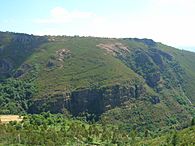
A fold formation in Campodola-Leixazos, Serra do Courel, Lugo Province.
-
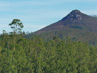
Pico Sacro near Boqueixón.
-
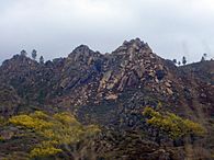
Mountain peaks near Verín.
-
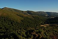
A view of Serra do Faro.


See also
 In Spanish: Macizo Galaico-Leonés para niños
- Cantabrian Mountains
- Geography of Galicia
- Geography of Spain
- Geology of the Iberian Peninsula
