Geography of Panama facts for kids
 |
|
| Continent | Central America |
|---|---|
| Region | Central America |
| Coordinates | 9°00′N 80°00′W / 9.000°N 80.000°W |
| Area | Ranked 116th |
| • Total | 75,417 km2 (29,119 sq mi) |
| • Land | 98.57% |
| • Water | 1.43% |
| Coastline | 2,490 km (1,550 mi) |
| Borders | Total border: 555 km (345 mi) |
| Highest point | Volcán Barú 3,475 metres (11,401 ft) |
| Lowest point | Pacific Ocean 0 metres (0 ft) |
| Longest river | Chucunaque River 231 km (144 mi) |
| Largest lake | Gatun Lake 425 km2 (164 sq mi) |
| Exclusive economic zone | 335,646 km2 (129,594 sq mi) |
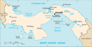
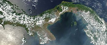
Panama is a country in Central America. It sits between the Caribbean Sea and the Pacific Ocean. Panama shares borders with Colombia and Costa Rica. It is famous for its narrow strip of land called the Isthmus of Panama.
This S-shaped land connects North and South America. Panama is about 75,417 km2 (29,119 sq mi) in size. It stretches 772 km (480 mi) long. Its width varies from 60 kilometers (37 miles) to 177 kilometers (110 miles).
Contents
What is Panama's Geology Like?
The land of Panama has a very complex geology. It was formed over the last 10 million years. This happened because several tectonic plates moved and interacted.
How High Are Panama's Mountains?
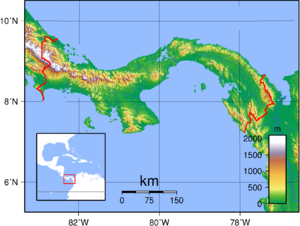
Panama has a central chain of mountains and hills. This chain forms the continental divide. This means it separates rivers that flow to the Pacific from those that flow to the Caribbean. These mountains are not part of the big mountain ranges in North America. Only near Colombia do they connect to the Andes mountains of South America.
The western part of this mountain chain is called the Cordillera Central. It stretches from Costa Rica to a lower area near the Panama Canal. Inside the Cordillera Central, there are three smaller ranges. The tall Cordillera de Talamanca extends from Costa Rica. It holds Panama's highest point, Volcán Barú. This volcano is 3,475 meters (11,401 ft) high. Volcán Barú last erupted in 1550. The land around it has Panama's richest soil. Further east are the lower Serranía de Tabasará and Sierra de Veraguas ranges.
What is Panama's Climate?
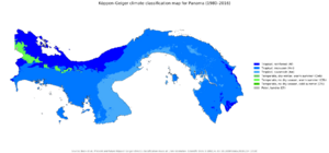
Panama has a tropical climate. This means it's always warm and humid. There isn't much change in temperature throughout the year. For example, in the capital city, the temperature might be 24 °C (75.2 °F) in the morning. It could reach 29 °C (84.2 °F) in the afternoon. It rarely goes above 32 °C (89.6 °F).
Temperatures are a bit cooler on the Pacific side of Panama. Breezes often pick up after sunset. In the higher mountain areas, it gets much cooler. Frost can even happen in the Cordillera de Talamanca.
The climate is mostly defined by rainfall. Rain varies from less than 1,300 millimeters (51.2 in) to over 3,000 millimeters (118.1 in) per year. Most of the rain falls during the rainy season. This usually lasts from May to November. The amount of rain depends on moisture from the Caribbean Sea. It also depends on the continental divide, which blocks rain for the Pacific lowlands.
Rainfall is usually much heavier on the Caribbean side. For example, Panama City gets about half the rain that Colón does. Even though thunderstorms are common, Panama is safe from hurricanes.
Panama City Weather
| Climate data for Panama City (1971–2000) | |||||||||||||
|---|---|---|---|---|---|---|---|---|---|---|---|---|---|
| Month | Jan | Feb | Mar | Apr | May | Jun | Jul | Aug | Sep | Oct | Nov | Dec | Year |
| Mean daily maximum °C (°F) | 31.7 (89.1) |
31.7 (89.1) |
32.2 (90.0) |
32.2 (90.0) |
31.1 (88.0) |
30.6 (87.1) |
30.6 (87.1) |
30.6 (87.1) |
30.0 (86.0) |
29.4 (84.9) |
30.0 (86.0) |
30.6 (87.1) |
31.0 (87.8) |
| Daily mean °C (°F) | 28.1 (82.6) |
28.1 (82.6) |
28.6 (83.5) |
28.9 (84.0) |
28.3 (82.9) |
27.8 (82.0) |
27.8 (82.0) |
27.8 (82.0) |
27.2 (81.0) |
27.0 (80.6) |
27.2 (81.0) |
27.5 (81.5) |
28.1 (82.6) |
| Mean daily minimum °C (°F) | 24.4 (75.9) |
24.4 (75.9) |
25.0 (77.0) |
25.6 (78.1) |
25.6 (78.1) |
25.0 (77.0) |
25.0 (77.0) |
25.0 (77.0) |
24.4 (75.9) |
24.4 (75.9) |
24.4 (75.9) |
24.4 (75.9) |
24.8 (76.6) |
| Average rainfall mm (inches) | 29.3 (1.15) |
10.1 (0.40) |
13.1 (0.52) |
64.7 (2.55) |
225.1 (8.86) |
235.0 (9.25) |
168.5 (6.63) |
219.9 (8.66) |
253.9 (10.00) |
330.7 (13.02) |
252.3 (9.93) |
104.6 (4.12) |
1,907.2 (75.09) |
| Average rainy days (≥ 0.1 mm) | 2.9 | 1.3 | 1.4 | 4.9 | 15.0 | 16.0 | 14.0 | 15.0 | 17.0 | 20.0 | 16.0 | 7.5 | 131.0 |
| Mean monthly sunshine hours | 228.9 | 245.2 | 183.9 | 173.1 | 108.5 | 116.3 | 106.1 | 118.1 | 99.2 | 103.9 | 139.8 | 120.5 | 1,743.5 |
| Source 1: World Meteorological Organization | |||||||||||||
| Source 2: ETESA (sunshine data recorded at Albrook Field) | |||||||||||||
David, Chiriquí Weather
| Climate data for David, Chiriquí | |||||||||||||
|---|---|---|---|---|---|---|---|---|---|---|---|---|---|
| Month | Jan | Feb | Mar | Apr | May | Jun | Jul | Aug | Sep | Oct | Nov | Dec | Year |
| Mean daily maximum °C (°F) | 32.2 (90.0) |
33.3 (91.9) |
33.9 (93.0) |
33.3 (91.9) |
31.7 (89.1) |
31.1 (88.0) |
30.6 (87.1) |
30.6 (87.1) |
30.6 (87.1) |
30.0 (86.0) |
30.0 (86.0) |
31.1 (88.0) |
31.5 (88.7) |
| Mean daily minimum °C (°F) | 21.7 (71.1) |
22.2 (72.0) |
22.8 (73.0) |
23.3 (73.9) |
23.3 (73.9) |
23.3 (73.9) |
23.3 (73.9) |
22.8 (73.0) |
22.8 (73.0) |
22.8 (73.0) |
22.8 (73.0) |
22.2 (72.0) |
22.8 (73.0) |
| Average rainfall mm (inches) | 33.3 (1.31) |
19.3 (0.76) |
35.5 (1.40) |
102.5 (4.04) |
297.0 (11.69) |
322.6 (12.70) |
289.8 (11.41) |
340.3 (13.40) |
406.6 (16.01) |
400.5 (15.77) |
295.4 (11.63) |
77.4 (3.05) |
2,620.2 (103.17) |
| Average relative humidity (%) | 67.7 | 62.6 | 62.4 | 69.6 | 79.5 | 81.1 | 80.4 | 81.1 | 82.1 | 83.8 | 82.8 | 75.5 | 75.7 |
| Mean monthly sunshine hours | 275.5 | 262.0 | 270.5 | 216.2 | 160.4 | 128.3 | 141.1 | 148.6 | 135.4 | 139.5 | 154.5 | 218.7 | 2,250.7 |
| Source 1: World Meteorological Organisation (UN) (30 yr record), | |||||||||||||
| Source 2: ETESA (humidity and sun values) | |||||||||||||
Colón Weather
| Climate data for Colón | |||||||||||||
|---|---|---|---|---|---|---|---|---|---|---|---|---|---|
| Month | Jan | Feb | Mar | Apr | May | Jun | Jul | Aug | Sep | Oct | Nov | Dec | Year |
| Mean daily maximum °C (°F) | 29 (84) |
29 (84) |
29 (85) |
30 (86) |
31 (87) |
30 (86) |
29 (85) |
29 (85) |
31 (87) |
30 (86) |
29 (84) |
29 (84) |
29 (85) |
| Mean daily minimum °C (°F) | 24 (76) |
24 (76) |
24 (76) |
25 (77) |
24 (76) |
24 (75) |
24 (75) |
24 (75) |
24 (75) |
23 (74) |
23 (74) |
24 (75) |
24 (75) |
| Average rainfall mm (inches) | 110 (4.3) |
51 (2.0) |
36 (1.4) |
94 (3.7) |
270 (10.8) |
370 (14.5) |
420 (16.5) |
420 (16.4) |
290 (11.5) |
470 (18.4) |
620 (24.4) |
320 (12.6) |
3,471 (136.5) |
| Source: Weatherbase | |||||||||||||
What Plants Grow in Panama?
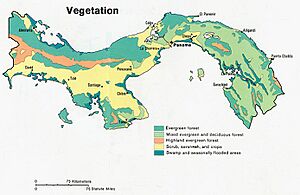
Panama's tropical climate helps many plants grow. Forests cover almost 40 percent of the country. You can also find grasslands and scrub areas. Sadly, deforestation is a big problem. Over half of Panama's tree cover has been lost since the 1940s.
Farmers grow corn, beans, and root crops in many areas. Along the coasts, you can see mangrove swamps. Near Costa Rica, there are also banana plantations. In many places, a thick rain forest grows right next to the swamps.
What Harbors Does Panama Have?
Panama has many good natural harbors along its Caribbean coast. The Archipiélago de Bocas del Toro islands offer a safe place for ships. They also protect the banana port of Almirante. The more than 350 San Blas Islands stretch for over 160 km (99 mi) along the coast.
On the Pacific side, the main port is Balboa. Important islands include the Archipiélago de las Perlas in the Gulf of Panama. There's also Isla de Coiba, a penal colony, and Taboga, a popular tourist spot near Panama City. In total, there are about 1,000 islands off the Pacific coast.
The Pacific coastal waters are very shallow. This causes extreme tides. On the Caribbean coast, the tide changes by only about 70 centimetres (2.3 ft). But on the Pacific coast, it can change by over 700 cm (23 ft).
What are Panama's Waterways Like?
Nearly 500 rivers flow through Panama's landscape. Most of them are not easy for boats to use. Many start as fast streams in the mountains. Then they wind through valleys and form deltas near the coast. The Río Chepo and the Río Chagres are used to create hydroelectric power. Kampia Lake and Madden Lake also provide electricity.
More than 300 rivers flow into the Pacific Ocean. These rivers are longer and flow slower than those on the Caribbean side. The Río Tuira is one of the longest. It flows into the Golfo de San Miguel. It is the only river in Panama that large ships can use.
How is Panama Divided?
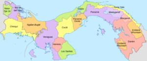
Panama is divided into 10 provinces. It also has several indigenous comarcas (special regions for native groups). These provinces are then split into districts. Districts are further divided into smaller areas called corregimientos. The boundaries of these areas change sometimes. This happens to match changes in the population.
Quick Facts About Panama's Geography
- Geographic coordinates: 9°00′N 80°00′W / 9.000°N 80.000°W
- Area:
- Total: 75,420 km2
- Land: 74,340 km2
- Water: 1,080 km2
- Land borders:
- Total: 555 km
- Border countries: Colombia 225 km, Costa Rica 330 km
- Coastline: 2,490 km
- Climate: Tropical, hot, humid, and cloudy. It has a long rainy season (May to January) and a short dry season (January to May).
- Terrain: The inside of the country has steep mountains and high plains. Coastal areas have mostly flat land and rolling hills.
- Extreme points:
- Northernmost point: Point Manzanillo
- Southernmost point: Punta Mariato, Cerro Hoya National Park, Veraguas
- Westernmost point: Border with Costa Rica, Chiriquí Province
- Easternmost point: Border with Colombia, Darién Province
- Lowest point: Pacific Ocean 0 m
- Highest point: Volcan de Chiriqui 3,475 m
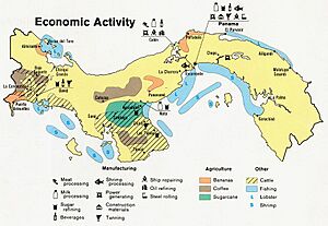
- Natural resources: copper, mahogany forests, shrimp, hydropower
- Land use:
- Land for farming: 7.16%
- Land for permanent crops: 2.51%
- Other land: 90.33% (2011)
- Natural hazards: Sometimes severe storms and forest fires in the Darien area, and earthquakes.
- Environmental issues: water pollution from farms harms fish. deforestation of rain forests is a problem. Land erosion can cause the Panama Canal to fill with dirt. Air pollution is an issue in cities. Mining also affects natural resources.
- Geography note: Panama has a very important location. It controls the Panama Canal. This canal connects the Atlantic Ocean (through the Caribbean Sea) with the Pacific Ocean. In central Panama, the sun rises over the Pacific Ocean and sets over the Atlantic Ocean, which is quite unusual!
See also
 In Spanish: Geografía de Panamá para niños
 | Kyle Baker |
 | Joseph Yoakum |
 | Laura Wheeler Waring |
 | Henry Ossawa Tanner |


