Geology of the Canary Islands facts for kids
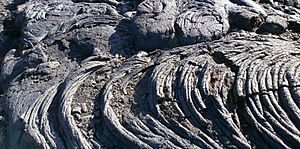
The geology of the Canary Islands is all about how these islands were formed and what they are made of. Mostly, they are built from volcanic rock. The Canary Islands and some underwater mountains nearby are part of a huge area called the Canary Volcanic Province. Volcanoes have been active here for a very long time, starting about 70 million years ago! Even today, the Canary Islands are still volcanically active. The most recent volcanic eruption on land happened in 2021, and the most recent underwater eruption was in 2011-2012.
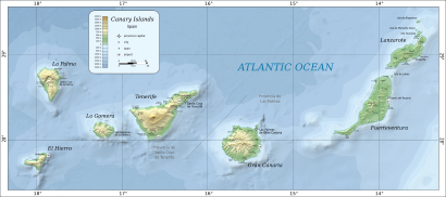
The Canary Islands are a chain of volcanic islands in the North Atlantic Ocean. They stretch for about 450 kilometers (280 miles) from east to west. They are located about 100 to 500 kilometers (60 to 310 miles) off the coast of Northwest Africa. These islands sit on the African Plate, which is one of Earth's giant tectonic plates. The Canary Islands are a great example of intraplate volcanism. This means their volcanoes are far from the edges of the African Plate, more than 600 kilometers (370 miles) away!
From east to west, the main islands are Lanzarote, Fuerteventura, Gran Canaria, Tenerife, La Gomera, La Palma, and El Hierro. There are also several smaller islands and islets. All seven main Canary Islands started as separate underwater volcanoes called seamounts. They grew from the ocean floor of the Atlantic Ocean, which is very deep here (1,000 to 4,000 meters or 3,300 to 13,000 feet).
Lanzarote and Fuerteventura are actually parts of one long volcanic ridge called the Canary Ridge. These two islands used to be connected as a single island in the past. Now, part of the ridge is underwater, and Lanzarote and Fuerteventura are separate. They are divided by a strait that is 11 kilometers (7 miles) wide and 40 meters (130 feet) deep.
Volcanoes have been active on all the main islands in the last 11,700 years, except for La Gomera.
Contents
How the Islands Grew
Volcanic oceanic islands, like the Canary Islands, form in the deep parts of the ocean. They grow through several stages:
- Underwater Stage: This is when the volcano starts growing on the ocean floor as a seamount.
- Shield-Building Stage: The volcano grows bigger, often forming a wide, gently sloping shield volcano.
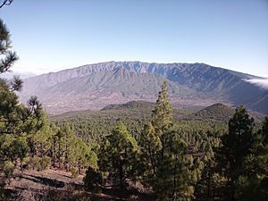
- Declining Stage: The volcanic activity starts to slow down (like on La Palma and El Hierro).
- Erosion Stage: Over time, wind and water wear down the island (like on La Gomera).
- Rejuvenation Stage: Sometimes, volcanic activity can start up again after a long break (like on Fuerteventura, Lanzarote, Gran Canaria, and Tenerife).
The Canary Islands are a bit different from other volcanic islands, like the Hawaiian Islands. For example, the Canary Islands have stratovolcanoes (cone-shaped volcanoes), and they don't sink as much into the ocean.
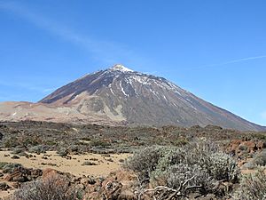
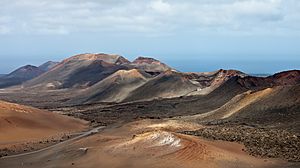
Each of the seven main Canary Islands began as a separate underwater volcano. These volcanoes grew from the ocean floor as many lava flows erupted. Eventually, each seamount grew tall enough to become an island. Once above water, volcanic eruptions continued. On Lanzarote and Fuerteventura, lava mostly flowed from long cracks in the ground, making the islands relatively flat. Their highest points are below 1,000 meters (3,300 feet). The other islands are much more rugged and mountainous. For example, the Teide volcano on Tenerife rises about 7,500 meters (24,600 feet) from the ocean floor! About 3,780 meters (12,400 feet) of that is underwater, and 3,715 meters (12,190 feet) is above sea level.
How Old Are the Islands?
The oldest lava flows found above sea level on each island get younger as you move from east to west. This shows how the islands formed over time:
- Lanzarote and Fuerteventura: 20.2 million years old
- Gran Canaria: 14.6 million years old
- Tenerife: 11.9 million years old
- La Gomera: 9.4 million years old
- La Palma: 1.7 million years old
- El Hierro: 1.1 million years old
Types of Rocks and Landforms
The volcanic rocks found on the Canary Islands are typical of oceanic islands. They include different kinds of alkali basalts, basanites, and other volcanic rocks like phonolites and trachytes.
You can also find some deeper rocks, called plutonic rocks, on Fuerteventura, La Gomera, and La Palma. These rocks formed slowly underground. Fuerteventura is special because it's one of the only oceanic islands known to have a rare rock type called carbonatite.
The Canary Islands are home to many cool volcanic landforms, including:
- Shield volcanoes (wide, gently sloped volcanoes)
- Stratovolcanoes (cone-shaped volcanoes)
- Calderas (large bowl-shaped hollows formed when a volcano collapses)
- Cinder cones (small, steep-sided cones)
- Lava flows and lava fields (areas covered by hardened lava)
- Volcanic plugs (hardened lava that fills a volcano's vent)
Why Do Volcanoes Form Here?
Scientists have come up with a few ideas to explain why there are volcanoes in the Canary Islands. Two main ideas are:
- Cracks in the Earth: One idea is that the volcanoes are linked to large cracks in the Earth's crust that extend from the Atlas Mountains in Morocco.
- Hotspot: The other idea is that the volcanoes are caused by the African Plate slowly moving over a very hot spot deep inside the Earth's mantle. This hot spot, called a hotspot, melts rock, which then rises to form volcanoes.
Most geologists who study the Canary Islands now believe that a hotspot is the best explanation for the volcanoes.
See also
 In Spanish: Geología de las Islas Canarias para niños
- Canary hotspot
- Geology of Cape Verde
- Geology of Madeira
- Geology of Morocco
- Savage Islands
 | Laphonza Butler |
 | Daisy Bates |
 | Elizabeth Piper Ensley |


