
Gloversville, New York facts for kids
Quick facts for kids
Gloversville
|
||
|---|---|---|
| City of Gloversville | ||

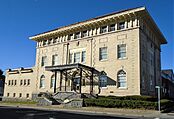
Chamber of Commerce Building
|
||
|
||

Gloversville
Location in New York
|
||
| Country | United States | |
| State | New York | |
| County | Fulton | |
| Incorporated (village) | 1853 | |
| Incorporated (city) | March 19, 1890 | |
| Government | ||
| • Type | Mayor-Council | |
| Area | ||
| • Total | 5.05 sq mi (13.09 km2) | |
| • Land | 5.05 sq mi (13.07 km2) | |
| • Water | 0.01 sq mi (0.02 km2) | |
| Elevation | 820 ft (250 m) | |
| Population
(2020)
|
||
| • Total | 15,131 | |
| • Estimate
(2022)
|
14,932 | |
| • Density | 2,998.61/sq mi (1,157.76/km2) | |
| Time zone | UTC-5 (Eastern (EST)) | |
| • Summer (DST) | UTC-4 (EDT) | |
| ZIP code |
12078, 12095
|
|
| Area code(s) | 518 | |
| FIPS code | 36-29443 | |
| GNIS feature ID | 0951265 | |

Gloversville is a city in the Mohawk Valley region of Upstate New York, United States. It is the largest city in Fulton County. Gloversville was once famous for making gloves. Over 200 glove factories were located here and in the nearby city of Johnstown. In 2020, about 15,131 people lived in Gloversville.
Contents
- History of Gloversville
- Geography of Gloversville
- City Life and Parks
- People of Gloversville (Demographics)
- Economy of Gloversville
- Education in Gloversville
- Transportation in Gloversville
- Sports in Gloversville
- Media in Gloversville
- Notable People from Gloversville
- Historic Places to Visit
- Gallery
- See also
History of Gloversville
People from Europe first settled in the Gloversville area around 1752. This area was known as "Kingsborough."
Early Settlers and the Name
Sir William Johnson, 1st Baronet gained control of the Mohawk Valley region. He was allied with the Native Americans. Because of him, the Six Nations Iroquois Confederacy supported England during the French and Indian War. Johnson was given a large piece of land called the Kingsborough Tract. Scottish Highlanders settled here.
In 1752, Arent Stevens bought land in the area. Later, Puritans from New England moved in. They used the houses left by the Highlanders. By 1803, about 1,400 people lived in Kingsborough. Most were of English descent.
The community was first called "Stump City." This was because many trees had been cut down. In 1828, a post office opened. The official name became "Gloversville." This name honored the growing glove industry.
The Glovemaking Industry
By 1852, Gloversville had 1,318 people. There were already 40 small glove and mitten factories. The area had many hemlock trees. Their bark was used for tanning leather. This made Gloversville a center for leather and glove production.
Gloversville became the main place for making gloves in America. From 1890 to 1950, 90% of all gloves sold in the U.S. were made here. Glove-making changed from home-based work to factory work. Large tanneries and glove shops hired almost 80% of the local people. Other businesses, like box makers, also opened to support the industry.
Gloversville became a village in 1853. It became a city in 1890. The city grew quickly. Its population went from 4,000 in 1877 to 13,864 in 1890.
Transportation and Decline
Until 1936, Gloversville had an electric train line. It was called the Fonda, Johnstown and Gloversville Railroad. This train connected Gloversville to other cities like Johnstown and Schenectady. Gloversville also became the main office for the Schine movie industry in the mid-1900s.
After the 1950s, the glove industry started to decline. This caused the city to lose many jobs. Many downtown stores closed. The city's population also went down. It was 23,634 in 1950 and fell to 15,665 by 2010.
Recent Efforts to Revitalize
In recent years, there have been plans to improve Gloversville. In 2018, new plans for downtown were announced. Mayor Vincent DeSantis proposed ideas to help the economy. In 2020, a company suggested building new shops and apartments. The city is also trying to attract new people and businesses.
Geography of Gloversville
Gloversville covers about 13.3 square kilometers (5.05 square miles). Only a tiny part of this area is water.
Roads and Waterways
New York State Route 29A (Fulton Street) runs east to west through the city. New York State Route 30A runs north to south along the eastern side. It connects Gloversville to Johnstown and Mayfield. New York State Route 309 (Bleecker Street) also starts in the center of Gloversville.
Cayadutta Creek flows south through the city. It is a small river that flows into the Mohawk River.
Climate and Weather
Gloversville is located near the Adirondack Mountains. This means it has a changing climate. Summers are warm, like in other parts of New York. But Gloversville gets more rain and snow throughout the year. In summer, there are often thunderstorms. In winter, it gets a lot of snow, similar to the higher mountains.
| Climate data for Gloversville, New York (12078) | |||||||||||||
|---|---|---|---|---|---|---|---|---|---|---|---|---|---|
| Month | Jan | Feb | Mar | Apr | May | Jun | Jul | Aug | Sep | Oct | Nov | Dec | Year |
| Record high °F (°C) | 68 (20) |
62 (17) |
83 (28) |
90 (32) |
90 (32) |
96 (36) |
98 (37) |
96 (36) |
99 (37) |
87 (31) |
77 (25) |
66 (19) |
99 (37) |
| Mean daily maximum °F (°C) | 28 (−2) |
32 (0) |
41 (5) |
55 (13) |
68 (20) |
76 (24) |
80 (27) |
79 (26) |
71 (22) |
58 (14) |
46 (8) |
34 (1) |
56 (13) |
| Mean daily minimum °F (°C) | 10 (−12) |
11 (−12) |
21 (−6) |
33 (1) |
44 (7) |
54 (12) |
58 (14) |
57 (14) |
48 (9) |
36 (2) |
28 (−2) |
17 (−8) |
35 (2) |
| Record low °F (°C) | −29 (−34) |
−26 (−32) |
−16 (−27) |
0 (−18) |
24 (−4) |
34 (1) |
40 (4) |
34 (1) |
22 (−6) |
15 (−9) |
−13 (−25) |
−23 (−31) |
−28 (−33) |
| Average precipitation inches (mm) | 3.20 (81) |
2.89 (73) |
3.88 (99) |
3.95 (100) |
4.16 (106) |
4.65 (118) |
4.35 (110) |
4.57 (116) |
3.70 (94) |
4.53 (115) |
3.10 (79) |
3.51 (89) |
46.49 (1,181) |
| Average snowfall inches (cm) | 24.2 (61) |
16.5 (42) |
13.4 (34) |
1.7 (4.3) |
0 (0) |
0 (0) |
0 (0) |
0 (0) |
0 (0) |
0.1 (0.25) |
3.7 (9.4) |
17.4 (44) |
77.0 (196) |
| Source: The Weather Channel | |||||||||||||
City Life and Parks
Gloversville has several neighborhoods and many parks.
Neighborhoods in Gloversville
Some of Gloversville's neighborhoods are Kingsboro, Saint Thomas Square, Bleecker Square, and Downtown.
Parks and Recreation
Gloversville has over 10 parks and public spaces. The largest is Herman Meyers Park, which is 50 acres. It was given to the city by Max Meyers to honor his father.
Trail Station Park is a very popular park. Many events happen there all year. These include the Annual Easter Egg Hunt, Fallfest, and Railfest. Summer concerts are also held there. In 2022, Governor Kathy Hochul announced money to expand this park.
Other parks in the city include:
- Union Street Park: Has an ice rink in winter and a football field in summer.
- Kingsboro Park: Features a World War 2 Monument.
- Melchoir Park: Has a fountain and sculptures.
- Ashley Park and Spring Street Park: Have playgrounds that are easy to use for everyone (ADA accessible).
- Elk Street Park (The Cage) and Darling Field: Both have basketball courts. Darling Field also has tennis courts.
People of Gloversville (Demographics)
| Historical population | |||
|---|---|---|---|
| Census | Pop. | %± | |
| 1870 | 4,518 | — | |
| 1880 | 7,133 | 57.9% | |
| 1890 | 13,864 | 94.4% | |
| 1900 | 18,349 | 32.3% | |
| 1910 | 20,642 | 12.5% | |
| 1920 | 22,075 | 6.9% | |
| 1930 | 23,099 | 4.6% | |
| 1940 | 23,329 | 1.0% | |
| 1950 | 23,634 | 1.3% | |
| 1960 | 21,741 | −8.0% | |
| 1970 | 19,677 | −9.5% | |
| 1980 | 17,836 | −9.4% | |
| 1990 | 16,656 | −6.6% | |
| 2000 | 15,413 | −7.5% | |
| 2010 | 15,665 | 1.6% | |
| 2020 | 15,131 | −3.4% | |
| U.S. Decennial Census | |||
In 2020, about 15,131 people lived in Gloversville. There were 6,232 households. Most people (88.2%) were White. About 1.7% were African American, and 1.2% were Native American. About 6.9% were from two or more races. About 4.6% of the population was Hispanic or Latino.
In 2020, 23.4% of the people were under 18 years old. About 7.6% were under 5 years old. And 18.3% were 65 years or older. Females made up 50.4% of the population.
The average age in Gloversville in 2018 was 40.5 years. The average household income from 2016 to 2020 was $38,620. About 21.5% of the city's residents lived below the poverty line.
Religion in Gloversville
Less than 30% of Gloversville's residents say they have a religious connection. This is lower than the average for Fulton County. The largest religion in Gloversville is Christianity. This includes Roman Catholic, Episcopal, United Methodist, and Presbyterian churches. Other Christian groups like Southern Baptist Convention and Assemblies of God are also present. The second largest religious group is Judaism. Some people also follow Eastern religions like Hinduism and Buddhism.
Economy of Gloversville
Gloversville was once a very important center for making gloves. At its busiest, there were over 200 glove companies in the city. Since the 1950s, the glove industry has declined. This has led to fewer jobs and economic challenges for the city.
From 1931 to 2005, a company that made music records was also located in Gloversville. It was first Brunswick Radio Corporation. Later, it became American Decca Records and then Universal Music.
Education in Gloversville
Gloversville is part of the Gloversville Enlarged School District. All the schools in this district are within the city. The only exception is Meco Elementary, which is just outside the city. Fulton–Montgomery Community College is also nearby.
Transportation in Gloversville
The city has its own bus service called the Gloversville Transit System (GTS). GTS buses run in Gloversville, Johnstown, and Amsterdam.
Trailways also has a bus terminal downtown. A private taxi company, Glove City Taxi, serves Gloversville and Johnstown.
Sports in Gloversville
Parkhurst Field is on Harrison Street. It is the home of the Gloversville Little League. As of 2022, Parkhurst Field is being updated with many improvements.
Gloversville also has the Kingsboro Golf Course. It is a 9-hole course with a restaurant. Another golf course, Pine Brook Golf Course, closed in 2012.
Media in Gloversville
The main local newspaper for Gloversville is The Leader-Herald. It has its main office in the city. Gloversville also has local radio stations like WENT (1340 AM) and WFNY (1440 AM). There is also a television station, WFNY-CD (channel 16).
Notable People from Gloversville
Many interesting people have connections to Gloversville:
- Actress Elizabeth Anne Allen, known for Buffy the Vampire Slayer, was born and grew up here.
- Actor Mischa Auer (1905–1967) is buried in Gloversville.
- Ambassador Samuel D. Berger (1911–1980) was born and raised in Gloversville. He was an important diplomat.
- Helen Broderick (1891–1959), a film and stage actress, lived here.
- Actress Betty Buehler was raised in Gloversville.
- Harvard University scientist Albert Coons grew up in Gloversville. He helped create immunofluorescence microscopy.
- Kenneth F. Cramer, a United States Army Major General, was born in Gloversville.
- Physicist William A. Edelstein, who helped develop MRI scanning, was born here.
- Samuel Goldwyn, a famous movie producer, worked as a glove maker in Gloversville when he first came to the U.S.
- Eugene Goossen (1921–1997), an art historian, was born in Gloversville.
- Hall of Fame harness racing driver Billy Haughton was born in Gloversville.
- Casey Johnston (born 1987), a fitness writer.
- Lucius Littauer, a former member of the United States House of Representatives, was born in Gloversville. He helped start Nathan Littauer Hospital.
- Actress Nicole Maines, who played Dreamer on Supergirl, was born in Gloversville.
- Patrick Peterson, a distance runner, is from Gloversville.
- Artist Frederic Remington once lived in Gloversville.
- Pulitzer Prize winning author Richard Russo was raised in Gloversville. His novels often feature places and people inspired by the city.
- David Smukler (1914–1971), an NFL football player.
- Harriet Mabel Spalding (1862–1935) was a writer and poet.
- Opera singer Sharon Sweet was born and raised in Gloversville.
Historic Places to Visit
Gloversville has two historic areas listed on the National Register of Historic Places (NRHP):
- Downtown Gloversville Historic District: This area includes parts of Main Street and Fulton Street.
- Kingsboro Historic District: This smaller area has historic houses, a church, a cemetery, and the Fulton County Museum.
There are also several individual buildings listed on the NRHP:
- First United Methodist Church
- Gloversville Armory
- Gloversville Free Library (now the Gloversville Public Library)
- Gustav Levor House
Gallery
-
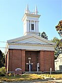
The Kingsboro Assembly of God Church was built in 1838. It is a key part of the Kingsboro Historic District.
-
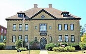
The Fulton County Museum is in an old school building from 1900.
-
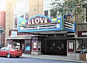
The Glove Theatre was the main theater for the Schine Enterprises chain.
-
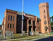
The Gloversville Armory was built in 1904. It is still used by the New York Army National Guard.
-
The Eccentric Club building, finished in 1908, is part of the Downtown Gloversville Historic District.
-
The Gloversville Public Library building is a Carnegie Library built in 1904.


See also
 In Spanish: Gloversville para niños
