Glynn County, Georgia facts for kids
Quick facts for kids
Glynn County
|
||
|---|---|---|

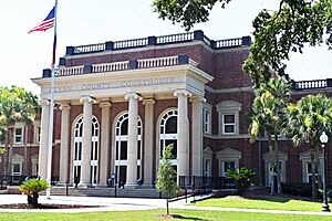
Glynn County Courthouse
|
||
|
||

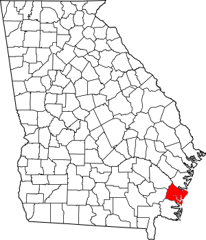
Location within the U.S. state of Georgia
|
||
 Georgia's location within the U.S. |
||
| Country | ||
| State | ||
| Founded | 1777 | |
| Named for | John Glynn | |
| Seat | Brunswick | |
| Largest city | Brunswick | |
| Area | ||
| • Total | 585 sq mi (1,520 km2) | |
| • Land | 420 sq mi (1,100 km2) | |
| • Water | 165 sq mi (430 km2) 28.3%% | |
| Population
(2020)
|
||
| • Total | 84,499 | |
| • Density | 201/sq mi (78/km2) | |
| Time zone | UTC−5 (Eastern) | |
| • Summer (DST) | UTC−4 (EDT) | |
| Congressional district | 1st | |
Glynn County is a place in the U.S. state of Georgia. You can find it in the southeastern part of the state. In 2020, about 84,499 people lived there. The main city and county seat is Brunswick. Glynn County is also part of the larger Brunswick Metropolitan Statistical Area.
Contents
History of Glynn County
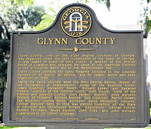
Glynn County was one of the first eight counties created in Georgia. This happened on February 5, 1777. The county was named after John Glynn. He was a member of the British House of Commons. He supported the American Colonies before the American Revolution began.
A famous battle, the Battle of Bloody Marsh, was fought in Glynn County. James Oglethorpe built Fort Frederica here. This fort was important during the American Revolutionary War. Glynn Academy is a very old school in Georgia. It was started to educate boys and is the second oldest school in the state.
Glynn County is home to some beautiful Sea Islands of Georgia. These include Jekyll Island, St. Simons Island, and Sea Island. A famous Georgia poet, Sidney Lanier, wrote a poem about the coast here. It's called "The Marshes of Glynn".
During World War II, a big training base was in Glynn County. It was called Naval Air Station Glynco. This base trained people to fly blimps and fight submarines. Today, a large part of this old base is used by the Federal Law Enforcement Training Center (FLETC). This center trains people for many different law enforcement jobs.
Geography of Glynn County

Glynn County covers a total area of about 585 square miles. About 420 square miles of this is land. The other 165 square miles (which is about 28.3%) is water.
Most of Glynn County is in the Cumberland-St. Simons area. This area is part of the St. Marys and Satilla River basin. The northern and northwestern parts of the county are in the Altamaha River basin.
Major Roads in Glynn County
 I-95 (Interstate 95)
 US 17
US 17 US 25
US 25 US 82
US 82 US 341
 SR 25
SR 25 SR 25 Conn.
 SR 25 Spur
 SR 27
SR 27 SR 32
SR 32 SR 99
SR 99 SR 303
 SR 405 (This is the hidden name for I-95)
 SR 520
Counties Next to Glynn County
- McIntosh County - to the north
- Camden County - to the southwest
- Brantley County - to the west
- Wayne County - to the northwest
Communities in Glynn County
City
Census-Designated Places
These are areas that are like towns but not officially incorporated as cities.
Unincorporated Communities
These are smaller communities without their own local government.
Ghost Towns
These are places where people used to live, but now they are empty.
- Belle Vista
- Bladen
- Thalmann
Population of Glynn County
| Historical population | |||
|---|---|---|---|
| Census | Pop. | %± | |
| 1790 | 413 | — | |
| 1800 | 1,874 | 353.8% | |
| 1810 | 3,417 | 82.3% | |
| 1820 | 3,418 | 0.0% | |
| 1830 | 4,567 | 33.6% | |
| 1840 | 5,302 | 16.1% | |
| 1850 | 4,933 | −7.0% | |
| 1860 | 3,889 | −21.2% | |
| 1870 | 5,376 | 38.2% | |
| 1880 | 6,497 | 20.9% | |
| 1890 | 13,420 | 106.6% | |
| 1900 | 14,317 | 6.7% | |
| 1910 | 15,720 | 9.8% | |
| 1920 | 19,370 | 23.2% | |
| 1930 | 19,400 | 0.2% | |
| 1940 | 21,920 | 13.0% | |
| 1950 | 29,046 | 32.5% | |
| 1960 | 41,954 | 44.4% | |
| 1970 | 50,528 | 20.4% | |
| 1980 | 54,981 | 8.8% | |
| 1990 | 62,496 | 13.7% | |
| 2000 | 67,568 | 8.1% | |
| 2010 | 79,626 | 17.8% | |
| 2020 | 84,499 | 6.1% | |
| 2023 (est.) | 86,172 | 8.2% | |
| U.S. Decennial Census 1790-1880 1890-1910 1920-1930 1930-1940 1940-1950 1960-1980 1980-2000 2010 |
|||
| Race | Number of People | Percentage |
|---|---|---|
| White (not Hispanic) | 52,987 | 62.71% |
| Black or African American (not Hispanic) | 20,469 | 24.22% |
| Native American | 175 | 0.21% |
| Asian | 1,175 | 1.39% |
| Pacific Islander | 92 | 0.11% |
| Other/Mixed Race | 3,265 | 3.86% |
| Hispanic or Latino | 6,336 | 7.5% |
In 2020, there were 84,499 people living in Glynn County. There were 34,614 households and 22,352 families.
Education in Glynn County
The public schools in Glynn County are managed by the Glynn County School System. They make sure students get a good education.
Superfund Sites in Glynn County
Glynn County has some areas called "Superfund sites." These are places where pollution has happened, and they need special cleaning to make them safe again. There are four such sites in the county.
One of these sites was called "LCP Chemicals." This facility released a harmful metal called mercury into Purvis Creek. This creek flows into the Turtle River and nearby marsh areas.
The EPA looked into this site. They found that the mercury was harming wildlife. For example, endangered wood storks on St. Simons Island had mercury poisoning. Fish, shellfish, crabs, and other birds in the coastal waters also had this toxic metal. Cleaning up these sites helps protect the environment and the animals that live there.
See also
 In Spanish: Condado de Glynn para niños
 | Isaac Myers |
 | D. Hamilton Jackson |
 | A. Philip Randolph |


