Greeley, Kansas facts for kids
Quick facts for kids
Greeley, Kansas
|
|
|---|---|

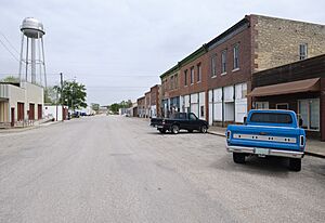
Downtown (2022)
|
|

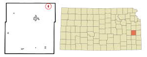
Location within Anderson County and Kansas
|
|

|
|
| Country | United States |
| State | Kansas |
| County | Anderson |
| Founded | 1854 |
| Incorporated | 1881 |
| Named for | Horace Greeley |
| Area | |
| • Total | 0.35 sq mi (0.91 km2) |
| • Land | 0.34 sq mi (0.89 km2) |
| • Water | 0.01 sq mi (0.02 km2) |
| Elevation | 896 ft (273 m) |
| Population
(2020)
|
|
| • Total | 273 |
| • Density | 780/sq mi (300.0/km2) |
| Time zone | UTC-6 (CST) |
| • Summer (DST) | UTC-5 (CDT) |
| ZIP code |
66033
|
| Area code | 785 |
| FIPS code | 20-28350 |
| GNIS ID | 2394972 |
Greeley is a small city in Anderson County, Kansas, in the United States. In 2020, about 273 people lived there. It's a quiet place with a rich history, especially from the early days of Kansas becoming a state.
Contents
History of Greeley
Early Days and Settlement
Long ago, before European settlers arrived, nomadic Native American tribes lived in the area where Greeley is now. These included the Wichita and the Osage. Later, in 1838, the Potawatomi people were moved to this area. They started subsistence farming, which means growing just enough food for themselves and their families.
The first European-American settlers came to Greeley in May 1854. Their names were Valentine Gerth and Francis Myer. Myer's cabin even served as the temporary county seat for Anderson County for a short time.
The town of Greeley was officially planned in December 1856. It was started by a group called Free-Staters. These were people who wanted Kansas to become a free state, meaning without slavery. The town was named after Horace Greeley, a famous newspaper editor who was against slavery.
Interestingly, the three main leaders who started the Greeley Town Company were all Ashkenazi Jews. Their names were August Bondi, Jacob Benjamin, and Theodore Wiener.
Post Office and Railroad
The town's post office opened in May 1857. However, there was a disagreement about its name. Government officials at the time didn't want to name it after an abolitionist (someone who wanted to end slavery). So, they named it "Walker" after the governor. The post office later moved and was finally named "Greeley" in April 1866.
In 1879, a railroad line reached Greeley. This was the St. Louis, Kansas and Arizona Railway, which was part of the Missouri Pacific Railroad. Today, this line is part of the Union Pacific Railroad. Greeley officially became an incorporated city in 1881. This means it was recognized as a legal town with its own local government.
20th Century Developments
In 1901, a cattle rancher named Colin Cameron started a large cattle operation just east of Greeley. His ranch, called Fields of Lochiel, was used to prepare Hereford cattle for sale in Kansas City.
Geography of Greeley
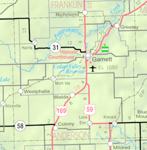
Greeley is located in the Pottawatomie Valley. It's near where the North Fork and South Fork of Pottawatomie Creek meet, which is called a confluence.
The United States Census Bureau says that Greeley covers about 0.37 square miles (0.91 square kilometers). Most of this area is land, with a very small part being water.
Street Names and History
Many of Greeley's streets that run east to west are named after important people from the "Bleeding Kansas" era. This was a time before the American Civil War when Kansas had a lot of fighting over whether it would be a free state or a slave state. These people were often Jayhawkers, who were anti-slavery fighters.
- Cochran Street is named for Benjamin L. Cochran. He helped found the town and was involved in important events like the Wakarusa War and the Battle of Black Jack.
- Kaiser Avenue is named for Charles Kaiser. He was an immigrant from Bavaria who was badly hurt in the Battle of Osawatomie.
- Brown Avenue is the main business street in Greeley. It's named after John Brown, a famous abolitionist.
- Bondi Avenue is named for August Bondi, one of the town's founders who also fought in the Battle of Black Jack.
- Mitchell Avenue is named for Robert B. Mitchell. He was a representative in the Territorial Legislature for Linn County.
Climate Information
Greeley has a climate with hot, humid summers and winters that are usually mild to cool. This type of weather is called a humid subtropical climate.
Population Data
| Historical population | |||
|---|---|---|---|
| Census | Pop. | %± | |
| 1870 | 145 | — | |
| 1880 | 285 | 96.6% | |
| 1890 | 514 | 80.4% | |
| 1900 | 394 | −23.3% | |
| 1910 | 492 | 24.9% | |
| 1920 | 496 | 0.8% | |
| 1930 | 504 | 1.6% | |
| 1940 | 387 | −23.2% | |
| 1950 | 436 | 12.7% | |
| 1960 | 415 | −4.8% | |
| 1970 | 368 | −11.3% | |
| 1980 | 405 | 10.1% | |
| 1990 | 339 | −16.3% | |
| 2000 | 327 | −3.5% | |
| 2010 | 302 | −7.6% | |
| 2020 | 273 | −9.6% | |
| U.S. Decennial Census | |||
2020 Census Details
The 2020 United States census counted 273 people living in Greeley. There were 124 households and 57 families. Most of the people (about 95%) were white. A small number were Native American, Asian, or of two or more races. About 1.5% of the population was Hispanic or Latino.
About 26% of the households had children under 18. Around 32% were married couples living together. The average household had 2.2 people. The average age in Greeley was about 40.9 years old.
2010 Census Details
In the census of 2010, Greeley had 302 people. There were 132 households and 84 families. The population density was about 839 people per square mile. Most people were White (97.4%).
About 29.5% of households had children under 18. Around 47.7% were married couples. The average household size was 2.29 people. The median age in the city was 38.3 years.
Education in Greeley
The public schools in Greeley are part of the Garnett USD 365 school district. Students attend Greeley Elementary School in Greeley. For junior high and high school, students go to Anderson County Junior-Senior High School in Garnett.
Notable People
- James G. Blunt: He was an important figure in Kansas history. He farmed near Greeley and was the highest-ranking Kansan in the Union Army during the Civil War.
- Dale Gear: He was a professional Major League Baseball player.
See also
 In Spanish: Greeley (Kansas) para niños
 | Dorothy Vaughan |
 | Charles Henry Turner |
 | Hildrus Poindexter |
 | Henry Cecil McBay |

