Greenfield, New York facts for kids
Quick facts for kids
Greenfield
|
|||
|---|---|---|---|
| Town of Greenfield | |||
|
|||

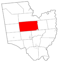
Map highlighting Greenfield's location within Saratoga County.
|
|||
| Country | United States | ||
| State | New York | ||
| County | Saratoga | ||
| Named for | Greenfield, New Hampshire | ||
| Area | |||
| • Total | 67.69 sq mi (175.31 km2) | ||
| • Land | 67.39 sq mi (174.54 km2) | ||
| • Water | 0.30 sq mi (0.77 km2) | ||
| Elevation | 591 ft (180 m) | ||
| Population
(2020)
|
|||
| • Total | 8,004 | ||
| • Density | 118.245/sq mi (45.656/km2) | ||
| Time zone | UTC-5 (Eastern (EST)) | ||
| • Summer (DST) | UTC-4 (EDT) | ||
| ZIP code |
12833
|
||
| Area code(s) | 518 | ||
| FIPS code | 36-30444 | ||
| GNIS feature ID | 0979019 | ||
Greenfield is a town in Saratoga County, New York. It's located northwest of Saratoga Springs. Greenfield is the biggest town in the county by its land area. Kids living in Greenfield go to schools in the Saratoga Springs City School District. The Palmertown and Kayaderosseras mountain ranges pass through the town. Greenfield is also found at the base of the Adirondack Mountains.
Contents
Where Did Greenfield Get Its Name?
The town of Greenfield was named after another place called Greenfield, New Hampshire.
A Look Back: Greenfield's History
People first started settling in the Greenfield area around 1786. In 1793, the town was officially formed. It was created from parts of two other towns: Milton and Saratoga. A year later, in 1794, some of Greenfield's land was used to create new towns. These new towns were Day, Corinth, and Hadley.
Greenfield's Geography and Size
Greenfield is the largest town in Saratoga County when it comes to land area. The town covers about 67.7 square miles (175.3 square kilometers) in total. Most of this area, about 67.4 square miles (174.5 square kilometers), is land. Only a small part, about 0.3 square miles (0.77 square kilometers), is water.
A main road called Route 9N runs through the eastern side of the town. This highway goes from north to south.
Who Lives in Greenfield?
| Historical population | |||
|---|---|---|---|
| Census | Pop. | %± | |
| 1800 | 3,073 | — | |
| 1810 | 3,087 | 0.5% | |
| 1820 | 3,024 | −2.0% | |
| 1830 | 3,151 | 4.2% | |
| 1840 | 2,803 | −11.0% | |
| 1850 | 2,890 | 3.1% | |
| 1860 | 2,970 | 2.8% | |
| 1870 | 2,698 | −9.2% | |
| 1880 | 2,448 | −9.3% | |
| 1890 | 2,169 | −11.4% | |
| 1900 | 1,837 | −15.3% | |
| 1910 | 1,552 | −15.5% | |
| 1920 | 1,481 | −4.6% | |
| 1930 | 1,544 | 4.3% | |
| 1940 | 1,698 | 10.0% | |
| 1950 | 1,961 | 15.5% | |
| 1960 | 2,548 | 29.9% | |
| 1970 | 4,378 | 71.8% | |
| 1980 | 5,104 | 16.6% | |
| 1990 | 6,338 | 24.2% | |
| 2000 | 7,362 | 16.2% | |
| 2010 | 7,775 | 5.6% | |
| 2020 | 8,004 | 2.9% | |
| U.S. Decennial Census | |||
According to the 2020 census, 8,004 people live in Greenfield. Back in 2000, there were 7,362 people. About 2,761 households and 2,007 families lived in the town at that time.
In 2000, most people in Greenfield were White (97.45%). A smaller number were African American (0.65%), Native American (0.14%), or Asian (0.34%). About 1.13% of the population was Hispanic or Latino.
Many households (38.1%) had children under 18 living with them. The average household had about 2.66 people. The average family had about 3.05 people.
The median age in Greenfield in 2000 was 36 years old. This means half the people were younger than 36, and half were older. About 27.2% of the population was under 18 years old.
Neighborhoods and Places in Greenfield
Greenfield has several smaller communities and locations within its borders:
- Ballou Corner – You can find this spot on Ormsbee Road. It's home to the Ballou Cemetery.
- Chatfield Corner – This is a small village, or hamlet, in the southwest part of town. It's located on County Road 12.
- Frink Corner – A location on the southern edge of the town, southwest of Middle Grove.
- Granite Lake – A community located on Braim Road.
- Greenfield – This is a hamlet in the southern part of the town, found on County Road 19.
- Greenfield Center – Another hamlet located on NY-9N, where it meets County Road 36.
- Kings – A hamlet south of North Greenfield, also on NY-9N.
- Lake Desolation – This name refers to two things: a hamlet in the northwest corner of the town on County Road 12, and a lake itself. The lake is mostly in Greenfield, but a small part is in Providence, New York.
- Middle Grove – A hamlet in the southwestern part of the town. It used to be known as "Jamesville."
- Mt. Pleasant – A location in the northwest corner of the town, north of Lake Desolation. It was once the busiest settlement in town but is now empty.
- North Greenfield – A hamlet on NY-9N, just north of Greenfield Center.
- Pages Corners – A hamlet near the southern town line, between Middle Grove and South Greenfield on County Road 21.
- Porter Corners – A hamlet southwest of North Greenfield on County Road 19.
- Sky Ranch – This location on Plank Road is higher up than most of the town.
- South Greenfield – A location south of the Greenfield village.
Famous People from Greenfield
Many interesting people have connections to Greenfield:
- William Aldrich (1820–1885) – Born in Greenfield Center, he became a United States Congressman for Illinois.
- Elihu Anthony (1818-1905) – An important pioneer in California.
- William Brayton (1787–1828) – He was a judge on the Vermont Supreme Court. He lived in Greenfield before going to college and moving to Vermont.
- Blackleach Burritt (1744–1794) – A well-known religious leader during the American Revolution.
- Harry Carman (1884–1964) – He was the dean of Columbia College.
- Sanford Robinson Gifford (1823–1880) – A famous artist from the Hudson River School.
See also
 In Spanish: Greenfield (Nueva York) para niños
 | Frances Mary Albrier |
 | Whitney Young |
 | Muhammad Ali |


