
Hartland, Connecticut facts for kids
Quick facts for kids
Hartland, Connecticut
|
||
|---|---|---|
| Town of Hartland | ||

Falls Brook in the Tunxis State Forest
|
||
|
||
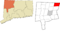
 Hartford County and Connecticut Hartford County and Connecticut Northwest Hills Planning Region and Connecticut Northwest Hills Planning Region and Connecticut |
||
| Country | ||
| U.S. state | ||
| County | Hartford | |
| Region | Northwest Hills | |
| Settled | 1754 | |
| Incorporated | 1761 | |
| Villages | East Hartland West Hartland |
|
| Government | ||
| • Type | Selectman-town meeting | |
| Area | ||
| • Total | 34.6 sq mi (89.6 km2) | |
| • Land | 33.1 sq mi (85.7 km2) | |
| • Water | 1.5 sq mi (3.9 km2) | |
| Elevation | 531 ft (162 m) | |
| Population
(2020)
|
||
| • Total | 1,901 | |
| • Density | 54.95/sq mi (21.217/km2) | |
| Time zone | UTC-5 (Eastern) | |
| • Summer (DST) | UTC-4 (Eastern) | |
| ZIP Codes |
06027, 06091
|
|
| Area code(s) | 860/959 | |
| FIPS code | 09-37140 | |
| GNIS feature ID | 0213443 | |

Hartland is a small town in Hartford County, Connecticut, United States. In 2020, about 1,901 people lived there. This quiet, rural town is part of the Northwest Hills Planning Region. It also forms the northwestern edge of Hartford County.
Today, Hartland has two main parts: East Hartland and West Hartland. These two areas are separated by the northern part of the Barkhamsted Reservoir. There used to be a third area called Hartland Hollow (or Hartland Center), but it was covered by water when the reservoir was finished in 1940.
Contents
History of Hartland
The area now known as Hartland was once called the "Western Lands." For 37 years, there was a disagreement over who owned this unsettled land. Both the Connecticut Colony (the government of Connecticut at the time) and the towns of Hartford and Windsor claimed it.
In 1724, people asked the Colony's General Court (a type of government assembly) to solve the problem. The court decided to divide the land among the three groups. Governor Joseph Talcott then issued an official document in 1729 to confirm this decision.
Later, in 1732, Hartford's landowners received a special document for four pieces of land. These pieces included what we now know as Hartland, Winchester, and New Hartford. Land in Hartland was given out based on how much land people owned in Hartford in 1720.
In 1733, 67 landowners formed a group called the Proprietors of Hartland. The General Court then officially named the area "Hartford land," which was later shortened to "Hartland."
The first people to settle permanently in Hartland were Captain Thomas Giddings Jr. and his wife Mary Coult in 1754. By 1761, there were 44 families living in Hartland. They asked the General Court to become an independent town, and Hartland was officially made a town that same year.
Geography and Nature
The Farmington River's east branch flows through the middle of Hartland. This river branch became the northern part of the Barkhamsted Reservoir. This happened after the Saville Dam was built in 1940. The reservoir and the land around it are owned by the Metropolitan District Commission (MDC). This group manages the water supply. The reservoir fills the valley between East and West mountains.
Hartland is located right next to the Massachusetts border to the north. The town covers about 89.6 square kilometers (34.6 square miles). Most of this area, about 85.7 square kilometers (33.1 square miles), is land. The rest, about 3.9 square kilometers (1.5 square miles), is water. The Farmington River, which flows into the Connecticut River, drains the town.
Hartland is home to parts of three Connecticut State Forests: Peoples State Forest, Tunxis State Forest, and American Legion State Forest. The Barkhamsted Reservoir is a huge lake that goes through the middle of Hartland. It is 11 miles long and holds about 30 billion gallons of water. This reservoir is the main source of drinking water for most of Hartford County.
Building the reservoir and the Saville Dam was a big project. It required more than 1,000 people to move from their homes. Four cemeteries and many family farms in Hartland and Barkhamsted also had to be relocated. Over 70% of Hartland's land, which is more than 15,500 acres, is protected as open space. This includes state forests, parks, and water supply lands.
Population of Hartland
| Historical population | |||
|---|---|---|---|
| Census | Pop. | %± | |
| 1800 | 1,318 | — | |
| 1810 | 1,284 | −2.6% | |
| 1820 | 1,254 | −2.3% | |
| 1830 | 1,221 | −2.6% | |
| 1840 | 1,060 | −13.2% | |
| 1850 | 848 | −20.0% | |
| 1860 | 846 | −0.2% | |
| 1870 | 789 | −6.7% | |
| 1880 | 643 | −18.5% | |
| 1890 | 565 | −12.1% | |
| 1900 | 592 | 4.8% | |
| 1910 | 544 | −8.1% | |
| 1920 | 448 | −17.6% | |
| 1930 | 296 | −33.9% | |
| 1940 | 300 | 1.4% | |
| 1950 | 549 | 83.0% | |
| 1960 | 1,040 | 89.4% | |
| 1970 | 1,303 | 25.3% | |
| 1980 | 1,416 | 8.7% | |
| 1990 | 1,866 | 31.8% | |
| 2000 | 2,012 | 7.8% | |
| 2010 | 2,114 | 5.1% | |
| 2020 | 1,901 | −10.1% | |
In 2023, there were about 1,971 people living in Hartland. The town had 818 households. Most of the homes, about 91%, were owned by the people living in them.
The population includes people of different ages. In 2023, about 18.8% of the people were 19 years old or younger. About 22.8% were between 60 and 69 years old. The average age in Hartland was 52 years old.
Education in Hartland
Hartland has its own school district, which includes one school called Hartland School. This school teaches students from Pre-Kindergarten up to eighth grade. In 2017, about 162 students were enrolled there.
After eighth grade, high school students from Hartland have several choices. They can attend special schools called CREC magnet schools, which focus on different subjects. They can also go to vocational schools in Connecticut, which teach job skills. Some students choose vocational-agricultural schools.
The town also has a designated public high school, which was Granby High School as of 2019. Students can also get a voucher to attend another town's public high school if they prefer. Because students have so many choices for high school, it's hard to track the overall graduation rates for the town.
From 2013 to 2017, about 73.1% of students attended public schools, while 26.9% went to private schools. By 2017, about 32% of adults in Hartland had a high school diploma. Another 12% had an associate degree, and 32% had a bachelor's degree or higher.
Places to See
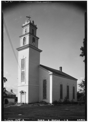
- Hartland Historical Society & Museum
- Tunxis Forest Headquarters House
- Tunxis Forest Ski Cabin
Famous People from Hartland
- Asher Benjamin, an architect (someone who designs buildings)
- Gary Burghoff, an actor
- Theophilus Gates, a religious leader
- Uriel Holmes, a congressman (a government official)
- Consider Tiffany, a British loyalist (someone who supported the British during the American Revolution)
- John Trumbull, an artist
- Cody Wolfe, a country music artist
Images for kids
-
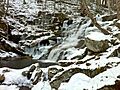
Falls Brook in the Tunxis State Forest
-
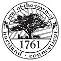
Seal of Hartland, Connecticut
-
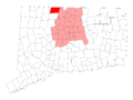
Hartland's location within Hartford County and Connecticut
-
Hartland's location within the Northwest Hills Planning Region and the state of Connecticut
See also
 In Spanish: Hartland (Connecticut) para niños
