
High Desert Discovery Scenic Byway facts for kids
Quick facts for kids
[[File:|x70px|alt= marker]] |
|
|---|---|

Scenic byway highlighted in green
|
|
| Route information | |
| Length | 127 mi (204 km) |
| Existed | 2003–present |
| Component highways |
|
| Major junctions | |
| North end | Burns |
| South end | Fields |
| Location | |
| Counties: | Harney |
| Highway system | |
| Oregon highways Routes • Highways |
|
The High Desert Discovery Scenic Byway is a super cool road trip in southeastern Oregon. It's about 127 miles (204 km) long and takes you through amazing desert landscapes. This special road connects the town of Burns to a small community called Fields. Oregon made it a "Scenic Byway" in 2003 because of its beautiful views and interesting places. The Oregon Department of Transportation (ODOT) takes care of the road.
Contents
Exploring the High Desert Discovery Byway
Starting Your Adventure from Burns
Your journey on the High Desert Discovery Scenic Byway begins in Burns. First, you'll travel east on Oregon Route 78 for about 1.5 miles (2.4 km). Then, you'll turn south onto Oregon Route 205. This is where the main scenic byway officially starts.
You'll drive about 27 miles (43 km) south across the Harney Basin. You'll reach a place called the Narrows interpretive site. This spot is near a bridge between Malheur and Harney lakes. It's a great place to learn about the area.
Driving Through Wildlife Refuges
After the Narrows, you'll keep going south on Route 205. You'll drive through the Malheur National Wildlife Refuge. This refuge is a huge protected area for animals. It stretches from the Narrows all the way to a small community called Frenchglen.
About 15 miles (24 km) north of Frenchglen, you'll see a turnoff for the Diamond Loop Tour Route. The main byway continues south. You'll arrive at Frenchglen, which is about 60 miles (97 km) south of Burns.
Journeying Towards Fields
The Steens Loop Tour Route also starts at Frenchglen. Nearby, about 1 mile (1.6 km) east, is the P Ranch Historic District. This is a historic site worth seeing.
From Frenchglen, the Discovery Byway heads west, then southwest. It goes over a low pass into the Catlow Valley, which is west of Steens Mountain. Soon after entering the valley, you'll see a turnoff for the Hart Mountain National Antelope Refuge. However, the byway stays on Route 205.
You'll pass by the Roaring Springs Ranch. The road runs next to the Catlow Rim for about 30 miles (48 km). Then, the byway turns southeast and starts to climb over Steens Mountain. Finally, the byway passes over Long Hollow Summit and goes down into the Pueblo Valley. The High Desert Discovery Scenic Byway ends at the small community of Fields. The whole trip is 127 miles (204 km) long.
Fun Side Trips and Alternate Routes
The High Desert Discovery Scenic Byway offers two exciting side trips. These are the Diamond Loop Tour Route and the Steens Loop Tour Route. They let you explore even more amazing places.
Discovering the Diamond Loop
The Diamond Loop Tour Route starts about 15 miles (24 km) north of Frenchglen. It heads east from the main byway. This loop is about 69 miles (111 km) long. On this tour, you can see cool rock formations. These include the Diamond Craters volcanic area. You can also visit the historic Pete French Round Barn. This barn is so important that it's listed on the National Register of Historic Places. There's even a modern visitor center at the barn site.
Exploring the Steens Loop
The Steens Loop Tour Route begins at Frenchglen. This loop is about 59 miles (95 km) long. It climbs all the way to the top of Steens Mountain. Then, it comes back down and connects with the main byway about 16 miles (26 km) south of Frenchglen.
From the East Rim Overlook, you can see the Alvord Desert far below, about 5,500 feet (1,676 m) down! The route also passes the Kiger Gorge Overlook. This is a viewpoint above a very deep, U-shaped valley carved by a glacier. You'll see several other viewpoints along the top of Steens Mountain. This tour is a great chance to spot Bighorn sheep on the mountain’s rocky cliffs. Just remember, the Steens Mountain loop road is closed during the winter months.
Amazing Places to See Along the Byway
Oregon's scenic byway program helps protect beautiful roads. It also creates fun opportunities for travelers. These byways show off the amazing natural, historic, and cultural features of the areas. All Oregon byways are kept in good condition by the Oregon Department of Transportation.
_(harDA0170).jpg)
There are many interesting sights and places along the High Desert Discovery Scenic Byway. These include:
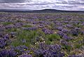
- Harney Basin
- Wright Point
- Narrows interpretive site
- Buena Vista Station
- Malheur National Wildlife Refuge
- Diamond Loop Tour Route
- Frenchglen Hotel (a historic hotel)
- P Ranch Historic District (another historic site)
- Steens Mountain Tour Route
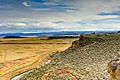
- Catlow Valley
- Roaring Springs Ranch
- Catlow Rim
- Long Hollow Summit Viewpoint
Spotting Wildlife on Your Trip
Besides these fixed points, the High Desert Discovery Scenic Byway is a fantastic place to see high desert wildlife. Many large mammals live in this area. You might spot them from the road! These animals include pronghorn, mule deer, elk, and wild horses.
You can also see many birds along the byway. Look for hawks and Golden eagles flying overhead. In the Malheur refuge part of the byway, you'll often see Sandhill cranes, Canada geese, tundra swans, and many kinds of ducks and shorebirds.
Byway Highlights
-
Wright's Point
-
Buena Vista
-
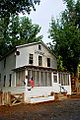
Frenchglen Hotel
-
Catlow Rim
-
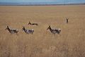
Catlow area pronghorn

.jpg)
_(harDA0011).jpg)


History of the Byway
How Scenic Byways Started
In 1991, a law called the Intermodal Surface Transportation Efficiency Act created the National Scenic Byways Program. The government put the Federal Highway Administration in charge of this program. The goal was to help local economies and tourism. It does this by protecting special roads, often in less-traveled parts of the country.
To be called a "scenic byway," a road must have unique natural, historical, or recreational value. It needs to be a special place to drive through.
The High Desert Discovery Byway's Story
In the early 1990s, two government groups, the United States Fish and Wildlife Service and the Bureau of Land Management, suggested a scenic byway. This proposed route would have gone between New Princeton and Lakeview. It would have passed through the Malheur National Wildlife Refuge and other natural areas. However, this longer national byway was never created.
Then, in 2003, the state of Oregon decided to create its own scenic byway. They chose a part of Oregon Route 205 and named it the High Desert Discovery Scenic Byway. This was a shorter route than the one first suggested. In the same year, the state also approved the Diamond Loop and Steens Loop scenic tour routes as part of the byway experience.
Major Road Connections
The entire route is in Harney County.
| Location | mi | km | Destinations | Notes |
|---|---|---|---|---|
| Burns | 0 | 0.0 | Beginning of the byway | |
| | 1 | 1.6 | ||
| | 44 | 71 | Diamond Lane | Junction with Diamond Loop Tour Route |
| Frenchglen | 60 | 97 | Steens Mountain Loop Road | Junction with Steens Loop Tour Route |
| | 71 | 114 | Steens Mountain Loop Road | Junction with Steens Loop Tour Route |
| Fields | 127 | 204 | End of the byway | |
| 1.000 mi = 1.609 km; 1.000 km = 0.621 mi | ||||
