
Hindelbank facts for kids
Quick facts for kids
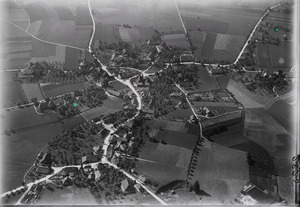
Hindelbank
|
||
|---|---|---|

Hindelbank
|
||
|
||

Hindelbank
Location in Switzerland

Hindelbank
Location in Canton of Bern
|
||
| Country | Switzerland | |
| Canton | Bern | |
| District | Emmental | |
| Area | ||
| • Total | 9.7 km2 (3.7 sq mi) | |
| Elevation | 519 m (1,703 ft) | |
| Population
(Dec 2020 )
|
||
| • Total | 2,519 | |
| • Density | 259.7/km2 (673/sq mi) | |
| Postal code |
3324
|
|
| Surrounded by | Bäriswil, Kernenried, Krauchthal, Lyssach, Mattstetten, Münchringen | |

Hindelbank is a town, also called a municipality, located in the Emmental area of Switzerland. It is part of the Bern canton. On January 1, 2021, the nearby town of Mötschwil joined with Hindelbank.
Contents
A Look Back: Hindelbank's History

Hindelbank was first mentioned in old records in 1275. Back then, it was known as Hundelwanc.
Scientists have found very old items in the village, possibly from the neolithic (New Stone Age) period. They also found signs of a Roman-era settlement at a place called Lindachfeld.
For a long time, Hindelbank was the center of a small local court. This court handled minor legal matters. From 1347 onwards, the village and its court were owned by different noble families. They would sell, divide, or pass it down through their families many times. In 1406, the city of Bern took control of the village. The local court continued to be run by Bernese nobles.
After the French invasion in 1798, the local court was closed. Five years later, Hindelbank became part of the Burgdorf district.
The Village Church
The village church was first mentioned in 1275. The original church was replaced with a new building between 1514 and 1518. The church tower was added much later, from 1666 to 1668. After a fire in 1911, the church was repaired and made new again. Inside the church, you can see two impressive tombs carved by a famous artist named Johann August Nahl.
Growth and Industry
Hindelbank was one of the first places to use machines for farming. In 1878, a cooperative for steam-powered farming was started here. Because of the local dairy and potato distillery, a yeast factory opened in 1888.
Over the years, other factories also opened, including:
- A biscuit factory in 1920
- A gravel mine in 1960
- A laundry
In the 1960s, a freight yard opened, which was great because it was close to the A1 motorway. Good transport links, like the motorway and the railway, have helped the town's population grow quickly. Even though more people live here now, many residents travel to nearby towns for work.
Education in Hindelbank
The first school in Hindelbank opened in 1662. The school building used today was built in 1903. In 1839, the local rectory (a house for a pastor) was turned into a school for training teachers. This school stayed open until 1918, when it moved to Thun.
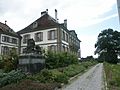
Hindelbank Castle
Between 1721 and 1725, a leader named Hieronymus von Erlach built a beautiful manor house called Hindelbank Castle. It was built near the old castle ruins in Wiler. In the 1700s, the castle became a famous place for important people to gather.
In 1866, Robert von Erlach sold the castle's land to a private owner. The castle itself was sold to the Canton of Bern. The canton then built a place for people who needed help, and later, in 1896, a women's prison on the castle grounds. The castle building was used for managing these facilities.
Mötschwil: A Neighboring Village
Mötschwil was first mentioned in 1328. Until 1910, it was known as Mötschwil-Schleumen.
The oldest sign of people living in this area is a cemetery from the La Tène period. Mötschwil and its smaller areas were part of the village of Alchenflüh for political and legal reasons. However, they were part of Hindelbank's church area and military district. In 1331, Fraubrunnen Abbey became a major landowner there.
From 1804, Mötschwil, Lyssach, and Rohrmoos (part of Oberburg) shared a school district. They built a school together in 1806. Even though it was close to the Hindelbank and Lyssach train stations, Mötschwil mostly remained a farming community.
Hindelbank's Geography

Hindelbank covers an area of about 6.74 square kilometers (2.6 square miles).
- About 60.8% of this land is used for farming.
- About 22.1% is covered by forests.
- About 16.3% has buildings or roads.
- A small part (0.4%) is rivers or lakes.
- A tiny bit (0.1%) is unproductive land.
Most of the built-up area is for housing and transportation. The forests are mostly dense. For farming, most land is used for growing crops, and some is for pastures. All the water in the town is flowing water, like streams.
Hindelbank includes the main village and the women's prison area in Wiler.
At the end of 2009, the old district of Burgdorf was closed. On January 1, 2010, Hindelbank became part of the new Emmental district.
Town Symbol: The Coat of Arms
The blazon (official description) of Hindelbank's coat of arms is: "A blue shield with a silver hind (female deer) standing on a golden base."
People of Hindelbank: Demographics


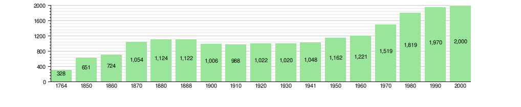
Hindelbank has a population of 2,519. In 2010, about 7.8% of the people living here were foreign nationals. Over the past 10 years (2000-2010), the population grew by about 7.2%.
Most people in Hindelbank (about 92.9% in 2000) speak German as their main language. French is the second most common language, and Portuguese is the third.
In 2008, about 49.3% of the population was male, and 50.7% was female.
The historical population of Hindelbank is shown in this chart:
Important Heritage Sites
The church, the rectory (pastor's house), and Hindelbank Castle are all very important historical sites in Switzerland. They are listed as heritage sites of national significance. The land around the castle and the small village of Mötschwil are also important heritage areas.
-
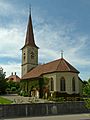
Hindelbank village church
-
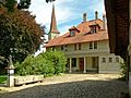
Hindelbank rectory
-
Hindelbank Castle


Economy and Jobs

In 2011, the unemployment rate in Hindelbank was about 2.18%. In 2008, there were 820 people working in the town.
- About 57 people worked in the primary sector, which includes farming.
- About 172 people worked in the secondary sector, which includes manufacturing and construction.
- About 591 people worked in the tertiary sector, which includes services like sales, transport, hotels, and healthcare.
Many people who live in Hindelbank travel to other towns for work. In 2000, about 780 workers left Hindelbank for jobs elsewhere, while 444 workers came into Hindelbank for work. Most people (49.4%) use a private car to get to work, while 20.9% use public transportation.
Religious Life

Based on the 2000 census:
- About 10.4% of the population was Roman Catholic.
- About 72.4% belonged to the Swiss Reformed Church (a Protestant church).
- A smaller number of people belonged to other Christian churches, or were Muslim, Jewish, Buddhist, or Hindu.
- About 5.2% of the population did not belong to any church.
Education in Hindelbank
In Hindelbank, about 43.2% of the population has finished upper secondary education (like high school). About 12.5% have gone on to higher education, such as a university or a specialized college.
The Canton of Bern's school system starts with one year of optional Kindergarten. Then, students attend six years of Primary school. After that, there are three years of mandatory lower Secondary school, where students are grouped by their abilities. After lower Secondary, students can choose to continue their education or start an apprenticeship (on-the-job training).
During the 2010-2011 school year, 350 students attended classes in Hindelbank. There were:
- 2 kindergarten classes with 37 students.
- 6 primary classes with 126 students.
- 11 lower secondary classes with 187 students.
Hindelbank also has a public library called the Gemeindebibliothek Hindelbank. In 2008, it had 5,400 books and other media. It loaned out 5,095 items that year.
Getting Around: Transportation
Hindelbank has its own railway station, Hindelbank. It is on the Olten–Bern line. You can catch regular trains from here to places like Bern, Thun, Langnau i.E., Solothurn, and Sumiswald-Grünen.
See also
 In Spanish: Hindelbank para niños
