
Victorville, California facts for kids
Quick facts for kids
Victorville, California
|
|||
|---|---|---|---|
|
|||

Location of Victorville in San Bernardino County, California
|
|||

Victorville, California
Location in California

Victorville, California
Location in the United States
|
|||
| Country | |||
| State | |||
| County | San Bernardino | ||
| Incorporated | September 21, 1962 | ||
| Named for | Jacob Nash Victor | ||
| Area | |||
| • City | 74.01 sq mi (191.69 km2) | ||
| • Land | 73.72 sq mi (190.94 km2) | ||
| • Water | 0.29 sq mi (0.74 km2) 0.76% | ||
| Elevation | 2,959 ft (902 m) | ||
| Population
(2020)
|
|||
| • City | 134,810 | ||
| • Rank | 5th in San Bernardino County 43rd in California |
||
| • Density | 1,821.51/sq mi (703.27/km2) | ||
| • Urban | 355,816 (US: 117th) | ||
| • Urban density | 2,700.2/sq mi (1,042.5/km2) | ||
| Time zone | UTC−8 (Pacific Time Zone) | ||
| • Summer (DST) | UTC−7 (PDT) | ||
| ZIP Codes |
92392–92395
|
||
| Area codes | 442/760 | ||
| FIPS code | 06-82590 | ||
| GNIS feature IDs | 2412156 | ||
| Website | www.victorvilleca.gov | ||


Victorville is a city in the Victor Valley area of San Bernardino County, California. In 2020, about 134,810 people lived here. It is the main city in the Victor Valley urban area. This area also includes Hesperia and Apple Valley. In 2020, this larger urban area had a population of 355,816 people.
Contents
History of Victorville
Early Beginnings: Lane's Crossing
In 1858, a man named Aaron G. Lane started a stop for travelers called "Lane's Crossing." This place helped people traveling across the desert to San Bernardino. Lane's Crossing was located by the Mojave River. Aaron Lane was a soldier who later sold supplies to miners. He moved to the Mojave River area in 1858 and set up his station.
Pioneer Station and Mormon Crossings
Later, Aaron Lane sold his station to John Fry Miller. Miller changed the name to Pioneer Station. Other families, like the Highmoors and Nicholsons, also set up similar stops nearby. In 1867, a new shortcut road was made across the desert. This road crossed the Mojave River at what became known as Mormon Crossing.
How Victorville Got Its Name
In 1885, a telegraph station was built for the railroad. It was named "Victor" after Jacob Nash Victor, a railroad manager. The small village that grew around this station was also called Victor. In 1901, the U.S. Post Office changed the name to Victorville. This was done to avoid confusion with another town called Victor in Colorado.
Route 66 and Air Force Base
In 1926, the famous U.S. Route 66 was created. Part of this historic road runs through Victorville. Later, in 1941, the Victorville Army Airfield was built. It became George Air Force Base in 1947. This base served the U.S. Air Force for many years. In 1992, the base closed. Part of its land is now the Southern California Logistics Airport. A federal prison, the Victorville Federal Penitentiary, was also built on some of the former base land. Victorville officially became a city on September 21, 1962.
Modern Events
In 2007, Victorville hosted the DARPA Urban Challenge. This was a special contest where robots drove cars by themselves through the streets. A team from Carnegie Mellon University won the $2 million first prize!
Geography of Victorville
Victorville is on the edge of the Mojave Desert. It is about 81 miles (130 km) northeast of Los Angeles. The city is bordered by Apple Valley to the east, Hesperia to the south, and Adelanto to the west. The Mojave River flows through Victorville sometimes. The city is about 2,950 feet (900 meters) above sea level. Victorville covers an area of about 73.7 square miles (191 km2). Most of this is land, with a small amount of water.
Victorville's Climate
Victorville has a cold desert climate with four different seasons.
Winter Weather
Winters in Victorville are mild to cool during the day. Nights can get very cold, often dropping to freezing or below. Temperatures can sometimes go below 25°F (–4°C). The coldest temperature ever recorded was –1°F (–18°C) in January 1949. Winter is when Victorville gets most of its rain. Snowfall is rare, usually just light flurries that melt quickly.
Spring Weather
Spring is a time of change. Daytime temperatures rise from below 70°F (21°C) in March to over 85°F (29°C) by late May. It starts cool at night but gets warmer as spring goes on.
Summer Weather
Summers are very hot. High temperatures often reach the high 90s°F (30s°C), and 100°F (38°C) is common. Sometimes, heat waves can push temperatures to 110°F (43°C). Even though days are hot, nights are much cooler, often dropping to the low 60s°F (15-18°C). This is because the desert air is very dry. Sometimes, summer thunderstorms can bring quick, heavy rain. The highest temperature ever recorded was 116°F (47°C) in July 2002.
Fall Weather
Fall is another changing season. High temperatures drop from the 90s°F (30s°C) to the 60s°F (15-20°C) in just two months. Freezing nights become common in November. Trees in the area change color and lose their leaves.
Victorville gets about 6.27 inches (159 mm) of rain each year. There are about 109 days a year where the temperature reaches 90°F (32°C) or higher. There are also about 79 days where the temperature drops to 32°F (0°C) or lower.
| Climate data for Victorville, California | |||||||||||||
|---|---|---|---|---|---|---|---|---|---|---|---|---|---|
| Month | Jan | Feb | Mar | Apr | May | Jun | Jul | Aug | Sep | Oct | Nov | Dec | Year |
| Record high °F (°C) | 80 (27) |
86 (30) |
93 (34) |
100 (38) |
108 (42) |
111 (44) |
116 (47) |
112 (44) |
110 (43) |
101 (38) |
88 (31) |
85 (29) |
116 (47) |
| Mean daily maximum °F (°C) | 60 (16) |
63 (17) |
68 (20) |
75 (24) |
84 (29) |
93 (34) |
99 (37) |
98 (37) |
92 (33) |
81 (27) |
68 (20) |
60 (16) |
78 (26) |
| Mean daily minimum °F (°C) | 31 (−1) |
35 (2) |
38 (3) |
42 (6) |
49 (9) |
55 (13) |
61 (16) |
61 (16) |
55 (13) |
45 (7) |
35 (2) |
30 (−1) |
45 (7) |
| Record low °F (°C) | −1 (−18) |
11 (−12) |
14 (−10) |
25 (−4) |
30 (−1) |
36 (2) |
36 (2) |
42 (6) |
32 (0) |
21 (−6) |
8 (−13) |
6 (−14) |
−1 (−18) |
| Average rainfall inches (mm) | 1.11 (28) |
1.18 (30) |
1.14 (29) |
0.31 (7.9) |
0.23 (5.8) |
0.06 (1.5) |
0.16 (4.1) |
0.25 (6.4) |
0.33 (8.4) |
0.26 (6.6) |
0.36 (9.1) |
0.81 (21) |
6.2 (157.8) |
| Average snowfall inches (cm) | 0.9 (2.3) |
0.0 (0.0) |
0.1 (0.25) |
0.0 (0.0) |
0.0 (0.0) |
0.0 (0.0) |
0.0 (0.0) |
0.0 (0.0) |
0.0 (0.0) |
0.0 (0.0) |
0.2 (0.51) |
0.1 (0.25) |
1.3 (3.31) |
| Source: Weather Channel | |||||||||||||
Victorville's People
Victorville has grown a lot over the years.
| Historical population | |||
|---|---|---|---|
| Census | Pop. | %± | |
| 1970 | 10,845 | — | |
| 1980 | 14,220 | 31.1% | |
| 1990 | 40,674 | 186.0% | |
| 2000 | 64,029 | 57.4% | |
| 2010 | 115,903 | 81.0% | |
| 2020 | 134,810 | 16.3% | |
| 2023 (est.) | 138,896 | 19.8% | |
| U.S. Decennial Census | |||
Population in 2020
In 2020, Victorville had a population of 134,810 people. About 55.4% of the people were of Hispanic or Latino background. The city is home to people from many different backgrounds.
| Race / Ethnicity (NH = Non-Hispanic) | Pop 2000 | Pop 2010 | Pop 2020 | % 2000 | % 2010 | % 2020 |
|---|---|---|---|---|---|---|
| White alone (NH) | 30,382 | 32,804 | 24,652 | 47.45% | 28.30% | 18.29% |
| Black or African American alone (NH) | 7,431 | 18,579 | 22,917 | 11.61% | 16.03% | 17.00% |
| Native American or Alaska Native alone (NH) | 380 | 754 | 692 | 0.59% | 0.65% | 0.51% |
| Asian alone (NH) | 2,095 | 4,341 | 5,262 | 3.27% | 3.75% | 3.90% |
| Pacific Islander alone (NH) | 107 | 390 | 672 | 0.17% | 0.34% | 0.50% |
| Other Race alone (NH) | 143 | 283 | 935 | 0.22% | 0.24% | 0.69% |
| Mixed race or Multiracial (NH) | 2,065 | 3,393 | 4,935 | 3.23% | 2.93% | 3.66% |
| Hispanic or Latino (any race) | 21,426 | 55,359 | 74,745 | 33.46% | 47.76% | 55.44% |
| Total | 64,029 | 115,903 | 134,810 | 100.00% | 100.00% | 100.00% |
Economy and Jobs
Victorville has several large employers. These include the Southern California Logistics Airport, Victor Valley College, and Desert Valley Hospital. Other important employers are Verizon, the local school districts, and the Federal Correctional Complex.
Top Employers in Victorville
| # | Employer | # of employees |
|---|---|---|
| 1 | Southern California Logistics Airport | 2,073 |
| 2 | Victor Valley College | 1,150 |
| 3 | Desert Valley Hospital | 1,000 |
| 4 | Verizon | 940 |
| 5 | Victor Valley Union High School District | 877 |
| 6 | Victor Elementary School District | 848 |
| 7 | Federal Correctional Complex, Victorville | 844 |
| 8 | Walmart | 830 |
| 9 | Victor Valley Community Hospital | 548 |
Education in Victorville
Victorville has several school districts for students.
- For elementary and middle school, there is the Victor Elementary School District (VESD), Adelanto Elementary School District (AESD), and Oro Grande Elementary School District.
- For high school, students attend the Victor Valley Union High School District.
- Some areas are served by Hesperia Unified School District and Snowline Joint Unified School District.
- For higher education, Victor Valley Community College is also in the city.
Transportation Hub
Victorville is an important transportation spot. The Amtrak Southwest Chief train stops at the Victor Valley Transportation Center. This center also has Greyhound Lines bus services. Local buses are provided by the Victor Valley Transit Authority. The city is also home to the Southern California Logistics Airport, which is a large airport for cargo and logistics. There are plans for a Brightline West high-speed rail line nearby, connecting to Las Vegas.
Landmarks and Attractions
Victorville has interesting places to visit. These include Spring Valley Lake and historic U.S. Route 66.
Old Town Victorville

Old Town Victorville is a historic area along Route 66. Efforts began in 1995 to improve this area. Projects here include the Veteran's Memorial, the Route 66 Museum, and the Old Victor School. You can also see several large murals painted on buildings in Old Town.
Filming Location
Victorville has been a popular spot for filming movies and TV shows! Its desert landscapes and unique buildings have appeared in many productions.
- 3 Bad Men (1926)
- It Came from Outer Space (1953)
- Grand Theft Auto (1977)
- The Hills Have Eyes (1977)
- The Hitcher (1986)
- Lethal Weapon (1987)
- From Dusk till Dawn (1996)
- Face/Off (1997)
- Breakdown (1997)
- Contact (1997)
- Kill Bill: Volume 2 (2004)
- The Fast and the Furious: Tokyo Drift (2006)
- Sky (2015)
Neighborhoods
Famous People from Victorville
Many notable people have connections to Victorville:
- Mike Alessi, motorcycle racer
- Harold Budd, composer
- Matt Chapman, professional baseball player
- Jesse Chavez, professional baseball player
- Ryan Garcia, professional boxer
- Amir Garrett, professional baseball player
- Patty Jenkins, director of Wonder Woman
- Trever Keith, musician
- Raven, drag queen and performer
- Dominick Reyes, MMA fighter
- Lee Rodriguez, actress
- Stevie Ryan, writer and comedian
- LaKeith Stanfield, actor
- Jason Vargas, professional baseball player
- Travis Van Winkle, actor
- Joel Pimentel, singer
Images for kids
-
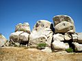
Rock Faces, non-prehistoric petroglyphs in Victorville

See also
 In Spanish: Victorville para niños
