
History of geomagnetism facts for kids

The history of geomagnetism is all about how we learned about Earth's magnetic field. This story includes how people started using compasses for navigation. It also covers how scientists studied the Earth's magnetic field from long ago (this is called archeomagnetism and paleomagnetism). This knowledge even helps us understand how plate tectonics works.
People have known about magnetism since ancient times. But understanding the Earth's own magnetic field took a long time. The first time someone measured the horizontal direction of the Earth's field was around 400 BC. However, the vertical direction wasn't measured until 1544 AD. And the strength of the field was first measured in 1791.
At first, people thought compasses pointed to places in the sky. Then, they believed compasses pointed to special magnetic mountains. A modern way of studying the Earth's field began with a book called de Magnete. It was published in 1600 by William Gilbert. He did experiments with a magnetic model of the Earth. These experiments convinced him that the Earth itself is a giant magnet.
Contents
Early Ideas About Magnets
People probably knew about magnetism when they first started working with iron. This was in prehistoric times. Iron can be found on the Earth's surface from meteorites. Also, a mineral called lodestone is very magnetic. It can become even more magnetic if lightning strikes it.
Pliny the Elder wrote about a legend in his book Natural History. It tells of a shepherd named Magnes the shepherd on the island of Crete. His boots had iron studs, and they kept sticking to the path! The very first ideas about magnetism came from Thales (who lived around 624 BC – 546 BC).
In ancient times, people didn't know much about magnetism. No old writings mention that magnets have two poles. They also don't mention that magnets tend to point north. There were two main ideas about where magnetism came from. One idea was that an invisible "effluvium" (like a tiny stream) flowed through materials. This was suggested by Empedocles and later by Plato. Another idea was that magnets had a special "sympathy" or connection with similar objects. This was thought to be caused by a life force. Aristotle believed Thales thought magnets had a soul. In China, people believed a similar life force, called qi, made magnets work. So, early Chinese compasses were used for feng shui.
Some old ideas about magnets lasted for a long time. Even after scientists started doing experiments. For example, people believed that eating garlic and onions could stop a compass from working. William Gilbert proved this wrong in 1600. But even after that, some British ship captains would punish sailors for eating garlic! However, not everyone believed this. In 1558, Giambattista della Porta wrote that sailors told him these were just "old wives’ fables."
Measuring Earth's Magnetism

To fully understand the Earth's magnetic field in one spot, you need three measurements. You can think of these as north, east, and down. Or, you can use angles: declination, inclination, and the field's strength.
First, you measure the declination. This is how much the compass needle points away from true north. It's a horizontal angle. This tells you the direction of magnetic North. Then, you can measure the inclination. This is a vertical angle, showing how much the field dips down.
In China, people measured the horizontal direction as early as the fourth century BC. They also noticed that the compass didn't always point to true north in 1088. This was the first time declination was recognized. In Europe, this idea wasn't widely accepted until the mid-1400s. Inclination (also called magnetic dip) was first measured in 1544 AD. The strength of the field wasn't measured until 1791. This happened after we learned more about electromagnetism.
Declination: How Far Off is North?

The magnetic compass existed in China as far back as the fourth century BC. It was used for feng shui and for navigation on land. Compasses weren't used for sea navigation until strong steel needles could be made. Before that, the needles couldn't stay magnetized for long.
The difference between magnetic north and true north is called magnetic declination. Shen Kuo was the first to notice this in 1088.
The first time a compass was mentioned in Europe was in 1190 AD by Alexander Neckam. He said it was a common tool for sailors. So, compasses must have arrived in Europe even earlier. We don't know if the knowledge came from China or was invented separately in Europe. If it came from China, Arab merchants were probably the ones who brought it. But Arab writings don't mention the compass until after Neckam. Also, Chinese compasses point south, while European ones point north.
In 1269, a man named Pierre de Maricourt (also known as Petrus Peregrinus) wrote a letter. He described two types of compasses. One was an oval lodestone floating in water. The other was the first dry compass, with a needle on a pivot. He was also the first to write about experiments with magnetism. He described how magnets attract and repel. For example, if you break a magnet, both pieces still have north and south poles. This letter, called Epistola de Magnete, was a very important step in science.
Petrus Peregrinus thought compasses pointed to true north. While some people like Roger Bacon might have noticed compasses were off, the idea of magnetic declination was accepted slowly. At first, people thought it was just a mistake in measurement. But by the mid-1400s, sundials in Germany were set using corrections for declination.
Inclination: The Dip of the Needle
A compass needle needs to be balanced. This is because the Earth's magnetic field pulls it down. If it's not balanced, it won't spin freely. Compasses balanced for one part of the world might not work well somewhere else.
Georg Hartmann, a vicar in Nuremberg, first reported this problem in 1544. The English sailor Robert Norman was the first to understand why this happens. He realized the Earth's field itself is tilted from straight up and down. In his book The Newe Attractive, Norman called inclination "a newe discouered secret."
Norman made a special compass. The needle floated in water, attached to a cork. This allowed the needle to point in any direction, so it dipped to line up with the Earth's field. Norman also created a dip circle. This was a compass needle that could pivot up and down. He used it to measure the dipping effect.
Old Ideas About Where Magnetism Comes From

In the past, understanding the Earth's magnetic field was hard. Not only was measuring it tough, but people didn't have the right ideas to explain it. They didn't have the concept of a "vector field" yet. This is a way to describe how a force (like magnetism) acts at every point in space.
The Earth's field is often shown with field lines that go from one pole to the other. The field at any point follows these lines. But it doesn't have to point directly at a pole. However, even in the 1700s, many thinkers believed a magnet had to point directly at something. So, they thought the Earth's magnetic field came from specific, local sources. As they learned more, these sources became more complicated.
At first, both in China and Europe, people thought the source was in the sky. Maybe the celestial poles or the Pole star. These ideas meant magnets should point almost exactly to true north. But this became a problem when people realized that compasses didn't always point to true north (declination). Then, people started to suggest earthly sources, like a special rock or mountain.
Stories about magnetic mountains are very old. Ptolemy told a legend about magnetic islands (thought to be near Borneo). These islands pulled so strongly on ships with nails that the ships couldn't move. Even more dramatic was an Arab legend (from One Thousand and One Nights). It said a magnetic mountain could pull all the nails out of a ship. This would make the ship fall apart and sink! This story came to Europe and appeared in many epic tales.
Europeans started putting magnetic mountains on their maps in the 1500s. A famous mapmaker, Gerardus Mercator, included one or two magnetic mountains near the North Pole on his maps. At first, he just put a mountain anywhere. Later, he tried to figure out its location using declination measurements from different places in Europe. When he got two different answers, he simply put two mountains on the map!
The Start of Modern Science

William Gilbert: Earth as a Giant Magnet
Magnus magnes ipse est globus terrestris. (The Earth itself is a great magnet.)
—William Gilbert, De Magnete
The year 1600 was very important for William Gilbert. He became the head of the Royal College of Physicians of London. He was also chosen as the personal doctor for Queen Elizabeth I. And he wrote De Magnete, one of the books that started modern science.
De Magnete is famous for two main things. First, it showed how important experiments are in science. Second, it proved that the Earth is a huge magnet.
Gilbert's book has six parts. The first part introduces his ideas. He talks about how important experiments are. He also shares facts about the Earth, like how small surface features are compared to the Earth's size. He then announces his big discovery: the Earth is a giant magnet.
In the second part, Gilbert talks about how magnets attract things. He explains the difference between magnetism and static electricity (which is caused by rubbing things like amber). He describes many experiments, some of which were done by Peregrinus earlier. One experiment shows that if you break a magnet, both pieces still have a north and south pole. He also said that perpetual motion (something that moves forever without stopping) is impossible.
The third part describes how magnets point. It also tells how to make a needle magnetic. Gilbert also introduces his terrella, or "little Earth." This is a magnetized sphere he used to model the Earth's magnetic properties. In parts four and five, he explains declination and inclination in more detail.

In the late 1590s, Henry Briggs published a table. It showed how magnetic inclination changed with latitude on Earth. Gilbert's measurements on his terrella matched Briggs's table well. Gilbert thought the Earth's magnetic field was like a uniformly magnetized sphere. He believed it was magnetized along the axis of rotation. (Today, we call this a geocentric axial dipole).
However, Gilbert knew that declination measurements didn't fit this model perfectly. He thought that continents, because they are raised, acted like centers of attraction. He believed they made compass needles point differently. He even showed this on his terrella by carving out some "topography" and measuring the effect. A monk named Niccolò Cabeo later showed that if the "topography" was scaled correctly for Earth, the differences would be tiny. So, continents couldn't really affect declination much.
The sixth part of de Magnete was about cosmology (the study of the universe). Gilbert didn't agree with the popular Ptolemaic model. This model said planets and stars were in shells rotating around the Earth. Gilbert said the speeds needed for this would be too fast. Instead, he believed the Earth rotated on its own axis. He also thought that heavenly bodies (like planets) interacted through magnetic forces. He believed magnetism kept the Earth in place and made it spin. He even thought the Moon's magnetic pull caused the tides. Both Kepler and Galileo liked Gilbert's idea of magnetic attraction between planets. But later, Newton's law of universal gravitation replaced this idea.
Changes Over Time

One of Gilbert's ideas was that the Earth's field could not change over time. But this was soon proven wrong by measurements in London. In 1580, William Borough measured the declination as 11.25° NE. In 1622, Edmund Gunter found it to be 5° 56' NE. He noticed the difference but thought Borough had made a mistake.
In 1633, Henry Gellibrand measured the declination in the same place. He found it was 4° 05' NE. Because Gunter had been so careful with his measurements, Gellibrand was sure the changes were real. In 1635, he published a book saying that the declination had changed by more than 7° in 54 years. People in England quickly accepted that the Earth's magnetic field changes over time. This is called geomagnetic secular variation. In other countries, people were doubtful until more measurements confirmed it.
Gellibrand's observations made people try to understand how the field changed. Was it global or local? Could it be predicted? It also led to new ideas about where the field came from. Henry Bond Senior became famous for predicting in 1639 that the declination in London would be zero in 1657. His idea involved a "precessing dipole" (a spinning magnet that wobbles). A royal commission criticized his model, but it was still published in navigation books for decades.
Other scientists also suggested models with multiple poles. These included Peter Perkins (1680) and Edmond Halley (1683, 1692). In Halley's model, the Earth was made of concentric spheres (like layers of an onion). Two magnetic poles were on the outer sphere. Two more were on an inner sphere that rotated westward. This caused a "westward drift" of the magnetic field. Halley was so proud of this idea that his portrait at age eighty included a diagram of it.
._HM_46._PORTOLAN_ATLAS_and_NAUTICAL_ALMANAC._France,_1543.C.jpg)
Early sailors used special maps called portolan charts. These maps showed coastlines and lines connecting ports. These lines were called windrose lines. A sailor could navigate by lining up the map with a compass and following the compass direction. Early maps had distorted coastlines because mapmakers didn't know about declination. But the maps still worked because sailors were just sailing in straight lines.
When boats mostly sailed in smaller seas like the Mediterranean, these straight lines were enough. But when they went into the Atlantic and Pacific oceans, it wasn't enough to just plot a straight course. Sailors needed to figure out their latitude and longitude.
From the 1500s to the mid-1800s, sailing ships were very important for international trade. Many European governments offered big prizes to the first person who could accurately find longitude. The British prize, called the longitude prize, led to the invention of the marine chronometer. This was a very accurate clock made by John Harrison, a clockmaker from Yorkshire.
See also
- History of geophysics
- Timeline of electromagnetic theory
- Rhumbline network
Images for kids
-
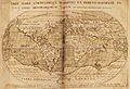
First map of the geomagnetic equator by Guillaume le Nautonier, published in 1603.

