Hypercane facts for kids
A hypercane is a super-powerful, imaginary type of tropical cyclone. It's like a hurricane, but much, much stronger. Scientists think a hypercane could form if ocean temperatures reached about 50 degrees Celsius (122 degrees Fahrenheit). This is 12 degrees Celsius warmer than the hottest ocean temperature ever recorded!
Such extreme warmth could be caused by huge events. Imagine a giant asteroid or comet hitting Earth, or a massive supervolcano erupting. Even "incredible" global warming could lead to these conditions. Some scientists believe that hypercanes might have played a role in the extinction of the dinosaurs. This idea was first suggested by Kerry Emanuel, a scientist from MIT. He also created the name "hypercane."
What Makes a Hypercane So Extreme?

For a hypercane to form, the ocean water would need to be at least 49 degrees Celsius (120 degrees Fahrenheit). A key difference between a hypercane and today's hurricanes is how high they reach. Regular hurricanes only go into the lower part of the stratosphere. But a hypercane would stretch much higher, deep into the upper stratosphere!
Hypercanes would have incredibly fast winds, possibly over 800 kilometers per hour (500 mph). Gusts could even reach 965 kilometers per hour (600 mph)! They would also have extremely low pressure at their center, less than 700 hPa. This low pressure would make them last for many weeks. The pressure inside a hypercane would be like being almost 3,000 meters (10,000 feet) high in the mountains. This could even cause altitude sickness!
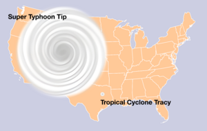
These giant storms could be as big as North America. To give you an idea, the largest and strongest storm ever recorded was Typhoon Tip in 1979. It had winds of 305 km/h (190 mph) and a central pressure of 870 hPa. A hypercane would be nearly eight times more powerful than Hurricane Patricia. Hurricane Patricia, in 2015, had the highest sustained winds ever recorded at 345 km/h (215 mph). However, some hypercanes might be smaller, perhaps only 24 kilometers (15 miles) wide. They would quickly lose power if they moved over colder waters.
After a hypercane passes, the ocean waters could stay hot for weeks. This means more hypercanes could form in the same area. The clouds from a hypercane would reach 30 to 40 kilometers (19 to 25 miles) high into the stratosphere. Such a powerful storm could also damage Earth's ozone layer. This layer protects us from harmful ultraviolet light from the sun. If the ozone layer is damaged, it could have serious effects on life on Earth. Water molecules from the storm in the stratosphere would react with ozone. This reaction would break down ozone, reducing its ability to block UV light.
How Hypercanes Get Their Power
Hurricanes get their energy from the difference in temperature between the warm ocean and the cooler air high up. They act like a giant engine. Warm, moist air rises from the ocean, releasing heat as it goes. This heat powers the storm.
In the case of a hypercane, the ocean would be so incredibly hot that this "engine" would go out of control. If the temperature difference between the sea and the top of the atmosphere is too big, the storm can't find a balance. More and more air would be sucked into the storm. This would release even more heat, making the central pressure drop even further. This creates a "runaway" effect, where the storm keeps getting stronger and stronger. Scientists are still studying what might eventually limit how powerful a hypercane could become.
See also
- Extraterrestrial cyclone
- Global catastrophic risk
- Great Dark Spot
- Great Red Spot
- Saffir–Simpson scale
- Tornado

