Joliet, Illinois facts for kids
Quick facts for kids
Joliet, Illinois
|
|||
|---|---|---|---|
Downtown
|
|||
|
|||
| Etymology: Louis Jolliet | |||
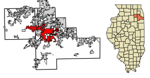
Location of Joliet in Will and Kendall counties in Illinois
|
|||
| Country | United States | ||
| State | Illinois | ||
| Counties | Will, Kendall | ||
| Townships | Joliet, Troy, Plainfield, Lockport, New Lenox, Jackson, Channahon, Seward, Na-Au-Say | ||
| Settled | 1833 | ||
| Incorporated | 1852 | ||
| Named for | Louis Jolliet | ||
| Government | |||
| • Type | Council–manager | ||
| Area | |||
| • Total | 65.82 sq mi (170.48 km2) | ||
| • Land | 65.08 sq mi (168.56 km2) | ||
| • Water | 0.74 sq mi (1.92 km2) | ||
| Elevation | 610 ft (190 m) | ||
| Population
(2020)
|
|||
| • Total | 150,362 | ||
| • Rank | US: 178th | ||
| • Density | 2,310.31/sq mi (892.02/km2) | ||
| Time zone | UTC−6 (CST) | ||
| • Summer (DST) | UTC−5 (CDT) | ||
| ZIP codes |
60431–60436, 60441, 60586
|
||
| Area code(s) | 815, 779 | ||
| FIPS code | 17-38570 | ||
| Airport | Joliet Regional Airport | ||
| GNIS feature ID | 2395477 | ||
| Demonym | Jolietan | ||
| Wikimedia Commons | Joliet, Illinois | ||
Joliet (/ˈdʒoʊliɛt, ˌdʒoʊliˈɛt/ joh-LEE-et-,_--et) is a city in Will and Kendall counties in the U.S. state of Illinois. It is about 35 miles (56 km) southwest of Chicago. Joliet is the main city of Will County. In 2020, it had a population of 150,362 people. This makes it the third-largest city in Illinois.
Contents
History of Joliet
Early Exploration and Settlement
In 1673, an explorer named Louis Jolliet and Father Jacques Marquette traveled up the Des Plaines River. They camped on a large hill near where Joliet is today. Old maps from Jolliet's trips showed this hill as "Mont Joliet." Over time, this mound was flattened due to mining.
In 1833, after the Black Hawk War, Charles Reed built a cabin on the west side of the Des Plaines River. In 1834, James B. Campbell started a village called "Juliet" on the other side of the river. This name was a simpler version of "Joliet." The village of Juliet became an official village just before an economic downturn in 1837. However, to save money on taxes, the people of Juliet soon asked the state to cancel its official village status.
Becoming a City
In 1845, the people living there decided to change the community's name from "Juliet" back to "Joliet." This was the original name. Joliet officially became a city in 1852. Cornelius Covenhoven Van Horne helped the city get its first official plan, called a City Charter. Because of his efforts, he was elected Joliet's first mayor. Later, when the city built a new bridge, they named it the Van Horne Bridge in his honor.
Geography and Climate
Joliet's Location and Shape
Joliet covers about 62.77 square miles (162.57 square kilometers). Most of this area is land. The city has a spread-out and uneven shape. It reaches into nine different townships, which is more than any other city in Illinois. These townships are in Will County and Kendall County. Joliet grew up along the Des Plaines River, and its downtown area is in the river valley.
East Side and West Side
Joliet has a "west side" and an "east side." These names refer to areas on either side of the Des Plaines River. For a long time, many businesses were in the downtown area. But as new highways and neighborhoods were built to the west, many stores moved. They went to new shopping centers on the west side, where there was more parking and easier access. This caused the downtown shopping area to become less busy.
Today, Joliet has a "west side" and a "far west side." The "far west side" includes all parts of the city that are in Kendall County. People now also talk about "Central Joliet." This is the land west of the Des Plaines River but east of Interstate 55.
Weather in Joliet
Joliet has a climate with hot, humid summers and cold winters. It gets a moderate amount of snow.
| Climate data for Joliet, Illinois (Brandon Dam), 1991–2020 normals, extremes 1975–present | |||||||||||||
|---|---|---|---|---|---|---|---|---|---|---|---|---|---|
| Month | Jan | Feb | Mar | Apr | May | Jun | Jul | Aug | Sep | Oct | Nov | Dec | Year |
| Record high °F (°C) | 65 (18) |
73 (23) |
86 (30) |
92 (33) |
95 (35) |
104 (40) |
103 (39) |
102 (39) |
97 (36) |
88 (31) |
78 (26) |
70 (21) |
104 (40) |
| Mean maximum °F (°C) | 53.8 (12.1) |
57.0 (13.9) |
70.5 (21.4) |
79.9 (26.6) |
87.7 (30.9) |
92.6 (33.7) |
93.7 (34.3) |
91.6 (33.1) |
89.6 (32.0) |
82.3 (27.9) |
68.2 (20.1) |
56.7 (13.7) |
95.0 (35.0) |
| Mean daily maximum °F (°C) | 31.1 (−0.5) |
35.4 (1.9) |
47.0 (8.3) |
59.9 (15.5) |
71.0 (21.7) |
80.3 (26.8) |
83.6 (28.7) |
81.8 (27.7) |
76.2 (24.6) |
63.3 (17.4) |
48.5 (9.2) |
36.4 (2.4) |
59.5 (15.3) |
| Daily mean °F (°C) | 23.9 (−4.5) |
27.6 (−2.4) |
38.1 (3.4) |
49.4 (9.7) |
60.2 (15.7) |
70.1 (21.2) |
73.9 (23.3) |
72.3 (22.4) |
65.7 (18.7) |
53.3 (11.8) |
40.4 (4.7) |
29.4 (−1.4) |
50.4 (10.2) |
| Mean daily minimum °F (°C) | 16.6 (−8.6) |
19.8 (−6.8) |
29.2 (−1.6) |
38.9 (3.8) |
49.4 (9.7) |
59.9 (15.5) |
64.1 (17.8) |
62.9 (17.2) |
55.3 (12.9) |
43.4 (6.3) |
32.3 (0.2) |
22.4 (−5.3) |
41.2 (5.1) |
| Mean minimum °F (°C) | −5.4 (−20.8) |
0.6 (−17.4) |
12.1 (−11.1) |
26.5 (−3.1) |
37.2 (2.9) |
47.1 (8.4) |
55.1 (12.8) |
54.6 (12.6) |
42.1 (5.6) |
30.0 (−1.1) |
18.7 (−7.4) |
3.1 (−16.1) |
−9.1 (−22.8) |
| Record low °F (°C) | −26 (−32) |
−20 (−29) |
−7 (−22) |
11 (−12) |
18 (−8) |
35 (2) |
47 (8) |
39 (4) |
32 (0) |
17 (−8) |
−2 (−19) |
−20 (−29) |
−26 (−32) |
| Average precipitation inches (mm) | 1.99 (51) |
1.78 (45) |
2.27 (58) |
3.93 (100) |
4.53 (115) |
4.30 (109) |
4.55 (116) |
3.97 (101) |
3.17 (81) |
3.14 (80) |
2.46 (62) |
1.94 (49) |
38.03 (966) |
| Average snowfall inches (cm) | 5.0 (13) |
6.2 (16) |
2.1 (5.3) |
0.1 (0.25) |
0.0 (0.0) |
0.0 (0.0) |
0.0 (0.0) |
0.0 (0.0) |
0.0 (0.0) |
0.0 (0.0) |
0.3 (0.76) |
3.2 (8.1) |
16.9 (43) |
| Average precipitation days (≥ 0.01 in) | 11.4 | 9.3 | 10.2 | 12.3 | 12.4 | 10.6 | 9.2 | 9.2 | 8.0 | 9.5 | 9.9 | 10.6 | 122.6 |
| Average snowy days (≥ 0.1 in) | 4.2 | 3.4 | 1.2 | 0.1 | 0.0 | 0.0 | 0.0 | 0.0 | 0.0 | 0.0 | 0.4 | 2.7 | 12.0 |
| Source: NOAA | |||||||||||||
People of Joliet
Population Changes Over Time
Joliet's population has grown a lot over the years. Here's how it has changed:
| Historical population | |||
|---|---|---|---|
| Census | Pop. | %± | |
| 1840 | 2,558 | — | |
| 1850 | 2,659 | 3.9% | |
| 1860 | 7,104 | 167.2% | |
| 1870 | 7,263 | 2.2% | |
| 1880 | 11,657 | 60.5% | |
| 1890 | 23,264 | 99.6% | |
| 1900 | 29,353 | 26.2% | |
| 1910 | 34,670 | 18.1% | |
| 1920 | 38,442 | 10.9% | |
| 1930 | 42,993 | 11.8% | |
| 1940 | 42,365 | −1.5% | |
| 1950 | 51,601 | 21.8% | |
| 1960 | 66,780 | 29.4% | |
| 1970 | 78,827 | 18.0% | |
| 1980 | 77,956 | −1.1% | |
| 1990 | 76,836 | −1.4% | |
| 2000 | 106,221 | 38.2% | |
| 2010 | 147,459 | 38.8% | |
| 2020 | 150,362 | 2.0% | |
| U.S. Decennial Census 2010 2020 |
|||
Who Lives in Joliet?
Here's a look at the different groups of people living in Joliet, based on recent counts:
| Race / Ethnicity (NH = Non-Hispanic) | Pop 2000 | Pop 2010 | Pop 2020 | % 2000 | % 2010 | % 2020 |
|---|---|---|---|---|---|---|
| White alone (NH) | 64,811 | 78,159 | 67,903 | 61.02% | 53.01% | 45.16% |
| Black or African American alone (NH) | 19,125 | 23,025 | 23,814 | 18.00% | 15.62% | 15.84% |
| Native American or Alaska Native alone (NH) | 159 | 192 | 156 | 0.15% | 0.13% | 0.10% |
| Asian alone (NH) | 1,190 | 2,747 | 2,927 | 1.12% | 1.86% | 1.95% |
| Pacific Islander alone (NH) | 14 | 18 | 21 | 0.01% | 0.01% | 0.01% |
| Other race alone (NH) | 103 | 153 | 464 | 0.10% | 0.10% | 0.31% |
| Mixed race or Multiracial (NH) | 1,267 | 2,097 | 4,567 | 1.19% | 1.42% | 3.04% |
| Hispanic or Latino (any race) | 19,552 | 41,042 | 50,510 | 18.41% | 27.84% | 33.59% |
| Total | 106,221 | 147,433 | 150,362 | 100.00% | 100.00% | 100.00% |
In 2010, about 30.8% of the people in Joliet were under 18 years old. The city was one of the fastest-growing cities in the Midwest between 2010 and 2011.
Religious Life
Joliet has many different faith communities. There are over 150 churches, synagogues, and other places of worship. These places also add to the city's beauty with their different styles of architecture. Joliet has a large Catholic population. You can find Catholic schools like Joliet Catholic Academy and the University of St Francis here.
Joliet's Economy
Like many cities that used to rely on factories, Joliet has faced economic challenges. However, the city is changing. It is becoming more of a place where people live and then travel to work in the larger Chicago metropolitan area.
Downtown Attractions
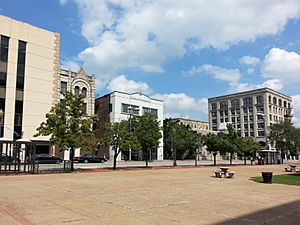
The downtown area of Joliet is slowly getting new businesses. Some of the main attractions there include the Harrah's Casino, the Joliet Slammers baseball team at Duly Health and Care Field, Hollywood Casino, and the Rialto Square Theatre. The Rialto Square Theatre is often called the 'Jewel of Joliet' and is known as one of the world's most beautiful theaters. Parts of the 1999 movie Stir of Echoes with Kevin Bacon were filmed at the Rialto.
Major Employers
Here are some of the biggest employers in Joliet:
| # | Employer | Employees |
|---|---|---|
| 1 | Amazon | 3,500 |
| 2 | AMITA Health Saint Joseph Medical Center | 3,023 |
| 3 | Will County | 2,200 |
| 4 | Joliet Junior College | 1,553 |
| 5 | Joliet Public Schools District 86 | 1,256 |
| 6 | Joliet Township High School District 204 | 916 |
| 7 | City of Joliet | 894 |
| 8 | Harrah's Joliet | 800 |
| 9 | ExxonMobil | 680 |
| 10 | Hollywood Casino Joliet | 600 |
Arts and Culture
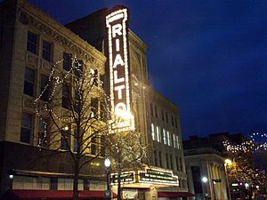
The Rialto Square Theatre is a famous building in downtown Joliet. It was even a filming location for scenes from the movie Stir of Echoes. Close to the theater is the Joliet Area Historical Museum. This museum tells the story of Joliet, especially its history as a stop on U.S. Route 66.
Other important places in Joliet include the Chicagoland Speedway for NASCAR races and the Route 66 Raceway for NHRA drag racing events.
Historic Buildings
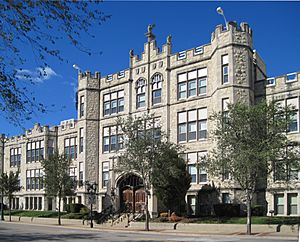
The Auditorium Building, built in 1891, is made of limestone. It was one of the first buildings to be used for religious, community, and business purposes all at once. Famous people like Theodore Roosevelt even visited and spoke there.
The Jacob A. Henry Mansion is a large, red-brick house built in 1873. It sits on a foundation of Joliet limestone from the owner's own quarry. The house has beautiful wood carvings and a solid-walnut staircase inside. The original owner, Mr. Henry, was a very successful railroad builder. This mansion is a local landmark and is listed on the National Register of Historic Places.
Other Fun Facts
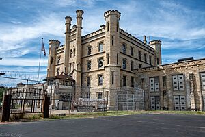
The Joliet Prison is located near downtown Joliet. This prison has been used as a filming location for TV shows and movies, including Prison Break and the opening scenes of The Blues Brothers movie.
Did you know that the very first Dairy Queen store opened in Joliet?
Joliet is the only city in Illinois that has two casinos: the Hollywood Casino and a Harrah's hotel and casino.
The Louis Joliet Mall is a large shopping center located near the intersection of I-55 and U.S. Route 30.
The former Joliet Arsenal is now home to the Abraham Lincoln National Cemetery and the Midewin National Tallgrass Prairie.
Sports in Joliet
Joliet has three high schools named after the city: Joliet Central, Joliet West, and Joliet Catholic Academy (JCA). JCA is especially known for its football team. They have won more state football titles than any other team in Illinois, with 15 wins as of 2023.
The University of St Francis in Joliet has many sports teams, known as the Fighting Saints. They compete in 20 different college sports.
Joliet also has a minor-league baseball team called the Joliet Slammers. They play their home games at Duly Health and Care Field. The Slammers won the Frontier League Championship in their very first season in 2011!
The Chicagoland Speedway used to host NASCAR events. When big races happened, the city's population would double with all the fans visiting. Right next to the Speedway is the Route 66 Raceway, which hosts National Hot Rod Association drag racing events. The Autobahn Country Club in Joliet also hosts car races.
Parks and Recreation
Golf Courses
Joliet has three golf courses: Inwood Golf Course, Woodruff Golf Course, and Wedgewood Golf Course. You can also play disc golf at Highland Park and West Park.
Family Fun and Nature
The Pilcher Park Nature Center, located within Pilcher Park, offers many programs for young people and educational activities. Pilcher Park is one of Joliet's oldest parks, with over 640 acres (259 hectares) of land. It's a great place to see wildlife and enjoy the outdoors. Pilcher Park also has Native American historical sites, including a burial mound.
Hammel Woods is another great spot in Joliet. It has miles of hiking trails and a seven-acre dog park. The Louis Joliet Mall also has a large Cinemark movie theater for entertainment.
Bicycle Trails
The Rock Run and Joliet Junction Trails are bicycle paths that start in Crest Hill and connect to the I&M Canal State Trail. These paths can form a 16-mile loop through western Joliet. The I&M Canal State Trail itself stretches about 60 miles (97 km). The Wauponsee Glacial Trail is also nearby.
Education
Most public school students in Joliet attend schools in Joliet Public Schools District 86 and Joliet Township High School District 204.
Colleges and Universities
- Joliet Junior College: This was the first public community college in the United States.
- University of St. Francis
High Schools
High schools in the Joliet area include:
- Joliet Catholic Academy
- Joliet Central High School
- Joliet West High School
Elementary and Middle Schools
Elementary and middle school districts serving Joliet include:
- Joliet Public Schools District 86
- Troy Community Consolidated School District 30-C
- Plainfield Community Consolidated School District 202
Job Training
The Job Corps has run the Joliet Job Corps Center since the early 1980s. This center helps young people get career training.
Transportation
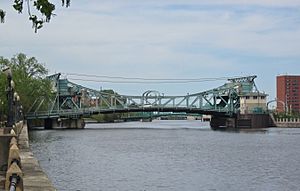
Joliet has always been an important place for transportation. It sits on both sides of the Des Plaines River, which is a major waterway. It was also a key port on the Illinois and Michigan Canal. Many railroads, like the Chicago & Rock Island and the Atchison, Topeka and Santa Fe, came through Joliet starting in the 1850s.
Several U.S. Highways, including 6, 30, 45, 52, and 66, all passed through the city. In the 1960s, Interstate 55 and Interstate 80 were built through Joliet. They connect near Channahon, just west of the city. The phrase "Crossroads of Mid-America" on Joliet's city seal refers to where I-80 and I-55 meet, and historically, where Route 66 and the Lincoln Highway crossed.
Train and Bus Services
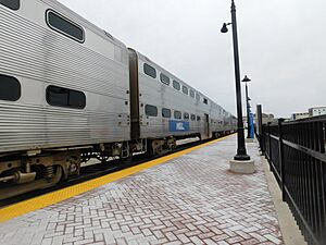
The Joliet Transportation Center is the last stop for Metra train lines from Chicago. These include the Heritage Corridor and Rock Island District routes.
Pace provides local bus service in Joliet six days a week. Buses leave from downtown Joliet every hour.
Amtrak also serves Joliet Union Station every day. You can take Amtrak trains like the Lincoln Service and Texas Eagle from Joliet to Chicago, St. Louis, and even Los Angeles.
Airports
The Joliet Regional Airport is located near Jefferson Street and Interstate 55. Another airport, Lewis University Airport, is in nearby Romeoville and is owned by the Joliet Regional Port District.
Major Roads
Here are the main highways in Joliet:
|
US Highways |
Hospitals
Joliet has one hospital within its city limits called Presence Saint Joseph Medical Center. Another hospital, Silver Cross Hospital, used to be on Joliet's east side. In 2012, Silver Cross Hospital moved to a new building in nearby New Lenox.
Notable People
See also
 In Spanish: Joliet (Illinois) para niños


