Kankakee Outwash Plain facts for kids
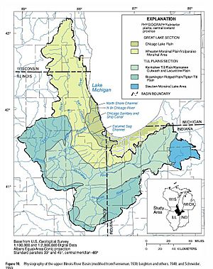
The Kankakee Outwash Plain is a flat area with sand dunes. It is found in the Kankakee River valley in northwestern Indiana and northeastern Illinois, USA. This plain is located just south of the Valparaiso Moraine. It was created during the Wisconsin Glaciation, which was a time when glaciers covered much of North America.
When the huge glacier stopped at the Valparaiso Moraine, it began to melt. The water from the melting ice, called meltwater, flowed away. This meltwater carried sand and mud with it. As the water reached the flatter valley, it slowed down. This caused the sand to settle, forming the smooth, flat, and sandy Kankakee Outwash Plain. Before it was drained, the Kankakee Marsh, which was part of this plain, was one of the biggest freshwater marshes in the United States.
Contents
How Glaciers Formed the Plain
The Kankakee Outwash Plain was shaped by the last Ice Age. The Wisconsin Glacial Episode started about 70,000 years ago. It removed all older land features. The land we see today was formed over the last 3,000 years.
Around 15,000 years ago, two large parts of the glacier, the Michigan lobe and the Huron-Saginaw lobe, started to melt back. This cleared the area that would become the Kankakee valley. About 14,000 years ago, the edge of the glacier stretched across Lake, Porter, and LaPorte counties. Here, new ice arriving from the north was balanced by melting.
Over thousands of years, the glacier pushed rock and soil southward. It released this material along its edge, building a ridge. This ridge is known as the Valparaiso Moraine.
Glacial Lake Kankakee
As soil piled up along the glacier's edge, a lot of water was released from melting ice. This water moved and sorted the soil. South of the glacier, water collected faster than it could drain away. This formed a large glacial lake, called Lake Kankakee.
Even though the bedrock is now deep under glacial sediments, it played a role. At Momence, Illinois, a ridge of limestone was exposed. All the water from the glacier had to flow west past this ridge. The Iroquois Moraine, south of glacial Lake Kankakee, blocked drainage in other directions. So, water from the glacier gathered between the Iroquois Moraine and the Momence Ridge.
How Sand Dunes Formed
The soils in the areas around the Kankakee are mostly loamy. This means they are a mix of clay, silt, and sand. However, the outwash plain itself has a lot of sand underneath, with layers of gravel.
As the glacier melted, the strong westerly winds began to shape the shores of "Lake Kankakee." They acted like the winds on the shores of Lake Michigan. This caused Dunes to form along the southern and eastern edges of the lake. Where large blocks of ice had melted, sand filled the hollows they left behind. Water flowing from the Valparaiso Moraine also created sand ridges leading into the lake.
As the glacier melted further north, the amount of water flowing into the lake decreased. The lake slowly drained and filled in. Since the water could not cut a channel through the limestone ridge at Momence, the Kankakee Lake turned into a huge marshland of about 500,000 acres.
Where the Plain Is Located
The Kankakee Outwash Plain is found on the southern side of the Valparaiso Moraine. It starts just west of the Illinois and Indiana border near Momence, Illinois. From there, it follows the Kankakee River valley eastward in a curve towards South Bend.
In Porter County, Indiana, the plain becomes wider. It stretches south from Valparaiso to below the Kankakee River, nearly 15 miles wide. Further east, in LaPorte County, the outwash plain extends from I-80/90 to the Kankakee River, along the Starke County line.
As the plain gets closer to South Bend, it narrows. It is squeezed between the Valparaiso Moraine and the till plain from the Saginaw ice lobe. Along the Michigan and Indiana border, the outwash plain forms a 10 to 15-mile-wide band along the St. Joseph River. The plain finally ends in LaGrange County, Indiana, east of the border with Elkhart County.
Parts of the Outwash Plain
- Kankakee River Plain: This is the largest part of the outwash plain. It runs along the Kankakee River from South Bend to the Illinois border. It is 15 to 20 miles wide and includes the Kankakee Marsh.
- Tippecanoe-Iroquois Plain: This is the next largest part. It is found along the Tippecanoe River in Fulton County. It reaches north into Starke County near Ora. To the south and west, it extends to Monticello and across the southern parts of Jasper County and Newton County, and northern White County. This area is drained by Monon Creek and the Iroquois River.
- St. Joseph, Kalamazoo, and Dowagiac Rivers: This section is mostly in southwest Michigan. A small part is in northern Indiana, east of South Bend, along the St. Joseph River. This area was drained by three different parts of the Laurentian glacier.
New Ideas About the Sand Islands
Recent studies on the "Sand Islands" of the Kankakee area have shown something interesting. The sand in these islands is the same type and age as the sand found deep within the dunes along Lake Michigan.
According to Professor Ron Janke from Valparaiso University, this suggests something new. It could mean that the dunes south of the Kankakee River were formed before the Valparaiso Moraine. This would have happened at a time when current theories believe the northern parts of Indiana were still covered by glacial ice. This new idea challenges what scientists previously thought about how the area was formed.
 | Selma Burke |
 | Pauline Powell Burns |
 | Frederick J. Brown |
 | Robert Blackburn |


