Kilcommon (County Mayo civil parish) facts for kids
Quick facts for kids
Kilcommon
Cill Chomain
|
|
|---|---|
| Country | Ireland |
| Province | Connacht |
| County | County Mayo |
| Elevation | 00 m (0 ft) |
| Irish Grid Reference | F820374 |
Kilcommon (which is Cill Chomáin in Irish) is a special kind of area called a civil parish in Erris, located in north County Mayo in Ireland. It's made up of two large pieces of land that stick out into the sea, called peninsulas: Dún Chaocháin and Dún Chiortáin.
Kilcommon has 37 smaller areas called townlands. Some of these are so far away that no one lives there! Most people live along the sides of Sruwaddacon Bay, which flows into Broadhaven Bay. You'll find villages like Glengad, Pollathomas, Rossport, Inver, and Carrowteige here. There are also people living in the Glenamoy area, which is further inland.
Contents
History of Kilcommon
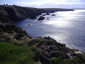
The name Kilcommon comes from a saint named St. Comán. He lived a very long time ago, around the end of the 500s AD. People believe that St. Comán is buried in the old churchyard at Pollatomais. You can still see parts of the old church walls there today. In 1838, some writers noted that only a small part of one wall was left, so it was hard to tell much about the church's original look or age.
The Landscape of Kilcommon
Much of Kilcommon is made up of high, open land called moorland, which is right next to the Atlantic Ocean. It's a wild and rugged place with huge areas of "blanket bog." A blanket bog is a type of wetland covered in thick moss and plants, like a blanket over the land.
You'll find tiny, quiet villages, beautiful white sandy beaches, and tall cliffs like Benwee Head. For thousands of years, this area has stayed mostly untouched by too much building or development. Farming here is small and doesn't use a lot of intense methods.
At the mouth of Broadhaven Bay, Kilcommon is known for its amazing views. It has huge cliffs and rocky islands called sea stacks. There are also miles of white sandy beaches, peaceful islands, and vast areas of blanket bog. This bog is home to many rare and delicate plants and animals. Unlike other parts of western Ireland, you won't see many huge rocks scattered around here.
The blanket bog changes its colors and textures with the seasons. Sometimes it's a bright, fresh green. Other times, it's purple and gold, covered with fluffy white bog cotton. In winter, it turns beautiful rustic shades of golden orange and red. The bog is always a living home for many insects, spiders, and plants that can only thrive in this special habitat. You might see grey-fronted geese flying overhead or even spot a rare bird like the corncrake or the red-necked phalarope. Kilcommon is the only place left in Ireland where the red-necked phalarope still breeds.
Kilcommon's Geology
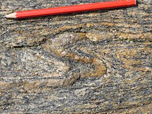
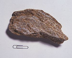
Kilcommon parish has a very old landscape. It's made of shiny rocks called schist and light, creamy rocks called psammite. You can also find pink-striped rocks called gneisses that are about two billion years old! Big white rocks called quartz can be found in the western part of the parish. These quartz rocks pushed their way into the ground about 450 million years ago, during a time of great geological activity.
When the blanket bog is cut away to get fuel for homes, you can see the bedrock underneath. This shows that the land has gone through huge changes over the last two billion years. It has experienced extreme heat, intense cold, pressure, and shifts in the Earth's crust. All these events have shaped the landscape into what it looks like today.
There are two main peninsulas in the parish: Dún Chiortáin and Dún Chaocháin. They are named after two giant brothers from local stories. Each brother had a Dún, which means a fort on a headland. The old tales say they used to share kitchen tools by throwing them across Sruwaddacon Bay (which means "Bay of the Long Hound"), the water that separated their lands.
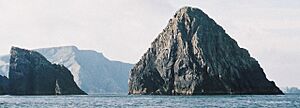
Sea cliffs run along much of the coast, from the 892-foot-high Benwee Head all the way to Glinsk mountain. You can see the rocky islands known as The Stags (or Stacks) off the northern coast of Kilcommon.
Archaeological Discoveries
In recent years, when people cut turf from the bog, they have found the fossilized remains of ancient Scots pine trees. These trees were part of huge forests that covered most of Ireland after the last Ice Age ended about 15,000 years ago.
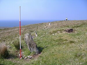
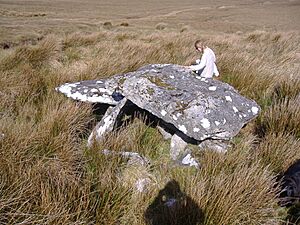
Kilcommon also has many archaeological remains, mostly in the western part. The eastern part was, and still is, hard to reach and not many people lived there. The area has a very large number of ancient tombs made of huge stones, called megalithic tombs. Most types of these tombs are found here. However, because not much money has been spent on archaeological studies in this parish, these ancient sites are not well documented.
In the eastern part of the parish, there's also evidence of possible crannogs in lakes. Crannogs are old artificial islands where people used to live. This suggests that some people lived in these areas in the past. Today, the growing blanket bog, new pine tree forests, and a lack of roads make townlands like Bunalty, Barrooskey, Baralty, Srahnaplaigh, and Muingnabo very difficult to reach.
In the western parts of the parish, you can see archaeological remains from many different time periods. These include the Mesolithic (Middle Stone Age), Neolithic (New Stone Age), Bronze Age, Iron Age, Early Christian times, and even from the Plantations period, right up to today.
Cliff Walks and Trails
There are several marked walking trails along the remote cliffs of Benwee Head in the north of the parish. Maps for these walks have been created by groups like Comhar Dún Chaocháin Teo, Ceathru Thaidhg as Dún Chaocháin Walks, and Suiloídi Iorrais. These maps help people explore the beautiful coastal paths.
The Irish Language in Kilcommon
A large part of Kilcommon (Cill Chomáin) parish is a Gaeltacht area, which means that the Irish language is spoken here every day. For example, Catholic Mass is celebrated in Irish in Ceathru Thaidhg, in the far north of the parish. There is also an Irish language summer school in Ceathru Thaidhg, where people can go to learn and practice Irish.
There are between 700 and 1,000 people in the parish who speak Irish as their first language.
Churches in the Parish
There are five Roman Catholic Churches in Kilcommon parish:
- Christ the King Church, Aughoose
- St. Paul's Church, Glenamoy
- St. Patrick's Church, Inver
- Star of the Sea Church, Cornboy
- Séipéal Muire gan Smál, Ceathru Thaidhg
During the 1700s, a time known as the Penal Times, the British government limited how many Roman Catholic priests there could be and where they could go. At that time, the Kilcommon parish covered almost all of the mainland Erris area, from Claggan, Ballycroy, to Portacloy. This large area and its boundaries are still used for some official purposes today.
Parish Divisions and Townlands
Kilcommon used to be a very large area, covering almost all of Erris. Because it was so big, in the early 1800s, it was divided into three smaller areas: Ballycroy, Kilcommon West, and Kilcommon East. Then, in 1873, it was reorganized again and split into four civil parishes: Kilmore, Ballycroy, Kiltane, and Kilcommon. These divisions are still in place today. The modern parish of Kilcommon has 37 townlands.
The Corrib Gas Project
Since the early 2000s, Kilcommon parish has been affected by the Corrib gas project. This project is owned by Royal Dutch Shell. For many years, there were disagreements about where a high-pressure gas pipeline should go through the area. Many parts of the project were strongly argued against by local people.
A gas processing plant was built 10 kilometers inland by Royal Dutch Shell, but it didn't have a direct way to connect to the gas coming from the sea. There were several public hearings about this issue. Eventually, permission was given for the project, and work started in July 2011. There have been many protests about the project over the years.
Natural Resources
Kilcommon in Erris has some of the best natural resources for alternative energy in the world. This is because of its location right on the Atlantic Ocean, which brings almost constant winds from the sea. The natural resources of the ocean and wind in Kilcommon are very valuable for making clean, renewable energy for the future.
There are good chances to develop projects that use the power of ocean waves, as some of the best wave energy resources in the world are found off the coast of North Mayo. Other clean energy options for the area include tidal power (using the movement of tides), hydroelectric schemes (using water flow), and large wind farms. These show that the area has great potential for a helpful and sustainable future.
|
 | Laphonza Butler |
 | Daisy Bates |
 | Elizabeth Piper Ensley |


