
Kiruna facts for kids
Quick facts for kids
Kiruna (Swedish)
|
|
|---|---|
| Kiruna - Giron | |

Clockwise from top: Kiruna skyline by night, Kiruna Church, the Icehotel in Jukkasjärvi, rocket launch at Esrange, bell tower at Kiruna Church.
|
|
| Country | Sweden |
| Province | Lapland |
| County | Norrbotten County |
| Municipality | Kiruna Municipality |
| City plan adopted | 27 April 1900 |
| Charter | 1 January 1948 |
| Area | |
| • Total | 16.53 km2 (6.38 sq mi) |
| Population
(30 September 2019)
|
|
| • Total | 22,906 |
| • Density | 1,098/km2 (2,840/sq mi) |
| Time zone | UTC+1 (CET) |
| • Summer (DST) | UTC+2 (CEST) |
| Website | kiruna.se |


Kiruna is the northernmost city in Sweden. It is located in the beautiful province of Lapland. In 2016, about 17,000 people lived there. Kiruna is the main town of Kiruna Municipality. The city was first built in the 1890s to support the big Kiruna Mine.
Kiruna is also a hub for space activities. The Esrange Space Center was built here in the 1960s. You can also find the Institute of Space Physics and a special space science department of Luleå University of Technology in Kiruna.
Contents
History of Kiruna
How Kiruna Began
People have lived in the Kiruna area for at least 6,000 years. This is known from old archaeological finds.
Long before Kiruna was founded in 1900, local Sámi knew about the iron ore in the hills of Kiirunavaara and Luossavaara. In 1736, a Sámi man named Mangi told Swedish officials about the ore. Soon after, a mapmaker named Anders Hackzell explored the area. He named the mountains after the Swedish King Fredrik I and his wife Ulrika Eleonora.
Mining was difficult because the area was so far away and the weather was harsh. Some ore was dug up in the 1800s. It was moved by reindeer and horses in winter. But it was expensive and the ore was not very good. This changed in 1878 with a new method called the Gilchrist–Thomas process. This method made it possible to separate phosphorus from the ore, making it useful.
In 1884, a plan for a railway from Luleå to Narvik was approved. This railway was very important for moving the ore. The company that started it went bankrupt, and the Swedish state bought the line.
In 1890, the mining company Luossavaara-Kiirunavaara Aktiebolag (LKAB) was started. LKAB wanted to extend the railway to the ice-free coast of Norway. This was a big decision, but it was finally approved in 1898. The railway reached Kiruna in 1899. The full line to Narvik opened in 1902.
Architects Per Olof Hallman and Gustaf Wickman designed the city. They thought about the cold climate and built Kiruna on a hill. This helps keep winter temperatures milder. The city plan was accepted in 1900.
Gustaf Broms suggested the name Kiruna. It is a short, easy name. In Sámi and Finnish, it means "rock ptarmigan," which is a type of bird. Hjalmar Lundbohm became the local manager for LKAB in Kiruna.
Early Days of the City
Before the city plan was ready, people built houses quickly and without much order. But official homes were built fast. By 1903, most of the temporary buildings were gone. In 1899, only 18 people lived in Kiruna. By 1910, this number grew to over 7,400!
The mining company LKAB paid for many important things. These included a hospital, a fire station, roads, and a church. The Kiruna Church opened in 1912.
In 1907, Kiruna got a tram system. It was the northernmost tram in the world! This helped miners get to work without walking far in the cold. The city tram closed in 1958, replaced by buses.

At first, mining was done on the surface of the mountain. Machines powered by steam were tried, but the cold made them hard to use. When electric machines became available in the 1910s, mining became much easier.
In 1909, many people left Kiruna during a big strike. Some even moved to Brazil, hoping for a better life. But most of them came back, as life there was not what they expected. Hjalmar Lundbohm even lent money to some to help them return.
During World War I, iron ore production dropped. But in the 1920s, it grew a lot. In 1921, mining also started at Kiruna's other hill, Luossavaara. However, the main focus remained on Kiirunavaara.
For many years, there was no road connecting Kiruna to the outside world. People traveled by railway or by boat in summer. Roads were slowly built, connecting Kiruna to other towns by 1926.
Tourism also started to grow. People came to see the rivers, mountains, and the mine. A yearly winter sports festival also began, attracting many visitors.
World War II and Kiruna
Kiruna is close to Norway and Finland. This meant many soldiers were sent to the area during World War II. Sweden remained neutral during the war.

After Germany invaded Norway, soldiers guarded bridges along the railway. They were ready to blow them up if Germany tried to invade Sweden. Foreigners were not allowed to visit Kiruna or the railway line.
Swedish iron ore from Kiruna was very important for Germany during the war. Some people working at LKAB planned to stop these shipments. One man, Edvard Nyberg, was caught and went to prison. After he was released, he started his own company, which is still one of Kiruna's biggest.
Germany asked to use the railway to move military equipment. Sweden only agreed to move "humanitarian" supplies, not things for fighting soldiers. But Germany still moved a lot of military gear and even troops through Kiruna.
During the war, up to 2,000 refugees from many countries stayed in Kiruna.
After the War
In 1948, Kiruna officially became a city. It received a lot of money from the mine. The city center was updated, and many new buildings were constructed. New neighborhoods were also built as the town grew.
After the war, Kiruna's economy started to grow in other ways. Many workshops began making machines for the mine. A fund was even set up to help new companies start in the area.

In 1960, Kiruna Airport opened for civilian flights. New roads were also built, connecting Kiruna to places like Nikkaluokta and Narvik. These new connections helped tourism grow even more.
The Icehotel in Jukkasjärvi was first built in 1990. It became a huge attraction, drawing tourists from all over the world.
Space research also grew in Kiruna. The Swedish Institute of Space Physics was founded in 1957. Esrange Space Centre opened in 1966. Here, rockets are launched, and satellites are tracked. Universities also started space engineering programs in Kiruna.
Moving the Town
Kiruna is facing a unique challenge: the mine under the city is causing the ground to sink. Because of this, the city center needs to move!

In 2004, it was decided that the city center would have to be relocated. The plan is to move it about 3 kilometers (2 miles) to the east. This is a huge project that will happen over many years.
The first work on moving the town began in 2007. Architects designed a new city center with a travel hub, a new city hall, and a new church. The plan also includes an artificial lake.
In 2010, the city council decided on the new location. The moving process started in 2014 and will continue for many decades. The new city will be more compact and focus on walking, public transport, and green spaces.
This big move is being carefully documented by photographers and researchers.
Geography of Kiruna
Kiruna is in northern Sweden, about 145 kilometers (90 miles) north of the Arctic Circle. The city center sits on Haukavaara hill, about 530 meters (1,740 feet) above sea level. The Torne River is to the north, and the Kalix River is to the south.

The mountains of Kiirunavaara and Luossavaara are near Kiruna. Kiirunavaara is the active iron ore mine. Luossavaara is a former mine that is now used for skiing.
Sweden's highest mountain, Kebnekaise, is about 75 kilometers (47 miles) from Kiruna. You can even see it from the city center! To the west are popular places like Abisko and Riksgränsen, leading to Narvik in Norway.
About 15 kilometers (9 miles) east of Kiruna is Jukkasjärvi. This is where the famous Icehotel is built every winter.
Kiruna became a Swedish city in 1948. For a time, it was called the largest city in the world by area. This was because its official borders covered a huge amount of land, even if most of it was not built up. Today, "city" mostly refers to the built-up area.
Climate and Weather
Kiruna is north of the Arctic Circle, so it has a subarctic climate. This means it has short, cool summers and long, cold winters. Snow usually covers the ground from late September to mid-May.
A special feature of Kiruna's location is the midnight sun. From May 28 to July 16, the sun never sets! This means 50 days of continuous daylight. In winter, from December 11 to January 1, the sun never rises above the horizon. This is called polar night.
Even though Kiruna's winters are very cold, they are not as harsh as places at similar latitudes in North America or Siberia. This is because of some influence from the ocean.
The coldest temperature ever recorded in Kiruna was -43.3°C (-45.9°F) in January 1999. The warmest was 31.6°C (88.9°F) in July 1945. Kiruna gets most of its sunshine between April and August. The darkest months are from October to February.
| Climate data for Kiruna Airport (2002–2021 averages, extremes since 1901), precipitation from Rensjön | |||||||||||||
|---|---|---|---|---|---|---|---|---|---|---|---|---|---|
| Month | Jan | Feb | Mar | Apr | May | Jun | Jul | Aug | Sep | Oct | Nov | Dec | Year |
| Record high °C (°F) | 7.3 (45.1) |
8.1 (46.6) |
9.5 (49.1) |
16.6 (61.9) |
24.9 (76.8) |
28.5 (83.3) |
31.6 (88.9) |
27.7 (81.9) |
23.3 (73.9) |
16.1 (61.0) |
10.1 (50.2) |
8.7 (47.7) |
31.6 (88.9) |
| Mean maximum °C (°F) | 2.7 (36.9) |
3.9 (39.0) |
5.0 (41.0) |
10.1 (50.2) |
19.1 (66.4) |
23.5 (74.3) |
24.6 (76.3) |
23.1 (73.6) |
17.8 (64.0) |
10.2 (50.4) |
4.9 (40.8) |
4.0 (39.2) |
26.2 (79.2) |
| Mean daily maximum °C (°F) | −7.9 (17.8) |
−6.7 (19.9) |
−2.4 (27.7) |
3.1 (37.6) |
8.9 (48.0) |
14.8 (58.6) |
18.5 (65.3) |
15.9 (60.6) |
10.2 (50.4) |
2.5 (36.5) |
−2.8 (27.0) |
−5.1 (22.8) |
4.1 (39.4) |
| Daily mean °C (°F) | −12.4 (9.7) |
−11.2 (11.8) |
−7.1 (19.2) |
−1.3 (29.7) |
4.7 (40.5) |
10.3 (50.5) |
13.8 (56.8) |
11.5 (52.7) |
6.5 (43.7) |
−0.7 (30.7) |
−6.5 (20.3) |
−9.3 (15.3) |
−0.1 (31.7) |
| Mean daily minimum °C (°F) | −16.8 (1.8) |
−15.7 (3.7) |
−11.8 (10.8) |
−5.6 (21.9) |
0.5 (32.9) |
5.7 (42.3) |
9.1 (48.4) |
7.0 (44.6) |
2.7 (36.9) |
−3.8 (25.2) |
−10.1 (13.8) |
−13.4 (7.9) |
−4.3 (24.2) |
| Mean minimum °C (°F) | −29.1 (−20.4) |
−28.1 (−18.6) |
−23.6 (−10.5) |
−16.2 (2.8) |
−6.7 (19.9) |
0.2 (32.4) |
3.1 (37.6) |
0.3 (32.5) |
−4.0 (24.8) |
−14.2 (6.4) |
−22.5 (−8.5) |
−25.1 (−13.2) |
−32.0 (−25.6) |
| Record low °C (°F) | −40.1 (−40.2) |
−42.3 (−44.1) |
−36.8 (−34.2) |
−31.1 (−24.0) |
−21.0 (−5.8) |
−5.0 (23.0) |
−1.8 (28.8) |
−5.0 (23.0) |
−11.8 (10.8) |
−28.8 (−19.8) |
−32.3 (−26.1) |
−37.5 (−35.5) |
−42.3 (−44.1) |
| Average precipitation mm (inches) | 25.7 (1.01) |
20.2 (0.80) |
15.2 (0.60) |
19.3 (0.76) |
44.8 (1.76) |
54.6 (2.15) |
92.7 (3.65) |
66.2 (2.61) |
57.8 (2.28) |
39.6 (1.56) |
25.8 (1.02) |
31.5 (1.24) |
493.4 (19.44) |
| Mean monthly sunshine hours | 8 | 69 | 162 | 208 | 238 | 244 | 244 | 180 | 118 | 75 | 21 | 0 | 1,567 |
| Source 1: SMHI Open Data for Rensjön A, precipitation | |||||||||||||
| Source 2: SMHI Open Data for Kiruna flygplats, temperature | |||||||||||||
| Climate data for Kiruna (Esrange 2002–2018, extremes since 1901) | |||||||||||||
|---|---|---|---|---|---|---|---|---|---|---|---|---|---|
| Month | Jan | Feb | Mar | Apr | May | Jun | Jul | Aug | Sep | Oct | Nov | Dec | Year |
| Record high °C (°F) | 7.3 (45.1) |
7.3 (45.1) |
11.3 (52.3) |
15.2 (59.4) |
27.0 (80.6) |
29.8 (85.6) |
31.6 (88.9) |
28.4 (83.1) |
24.3 (75.7) |
16.1 (61.0) |
9.2 (48.6) |
8.0 (46.4) |
31.6 (88.9) |
| Mean maximum °C (°F) | 1.4 (34.5) |
3.5 (38.3) |
5.9 (42.6) |
11.3 (52.3) |
21.0 (69.8) |
24.3 (75.7) |
25.3 (77.5) |
24.5 (76.1) |
18.3 (64.9) |
10.5 (50.9) |
4.8 (40.6) |
3.5 (38.3) |
27.3 (81.1) |
| Mean daily maximum °C (°F) | −9.1 (15.6) |
−7.2 (19.0) |
−1.8 (28.8) |
4.0 (39.2) |
10.3 (50.5) |
15.5 (59.9) |
19.7 (67.5) |
16.8 (62.2) |
10.9 (51.6) |
2.9 (37.2) |
−3.4 (25.9) |
−6.1 (21.0) |
4.4 (39.9) |
| Daily mean °C (°F) | −14.0 (6.8) |
−12.2 (10.0) |
−7.3 (18.9) |
−0.9 (30.4) |
5.4 (41.7) |
10.6 (51.1) |
14.5 (58.1) |
11.8 (53.2) |
6.6 (43.9) |
−0.6 (30.9) |
−7.5 (18.5) |
−10.9 (12.4) |
−0.4 (31.3) |
| Mean daily minimum °C (°F) | −18.8 (−1.8) |
−17.2 (1.0) |
−12.8 (9.0) |
−5.7 (21.7) |
0.5 (32.9) |
5.7 (42.3) |
9.2 (48.6) |
6.8 (44.2) |
2.3 (36.1) |
−4.1 (24.6) |
−11.6 (11.1) |
−15.7 (3.7) |
−5.1 (22.8) |
| Mean minimum °C (°F) | −32.9 (−27.2) |
−31.4 (−24.5) |
−27.3 (−17.1) |
−17.1 (1.2) |
−6.5 (20.3) |
−0.6 (30.9) |
2.9 (37.2) |
−0.7 (30.7) |
−4.7 (23.5) |
−15.0 (5.0) |
−24.9 (−12.8) |
−29.5 (−21.1) |
−35.7 (−32.3) |
| Record low °C (°F) | −43.3 (−45.9) |
−42.3 (−44.1) |
−36.8 (−34.2) |
−31.1 (−24.0) |
−21.0 (−5.8) |
−5.8 (21.6) |
−1.8 (28.8) |
−4.0 (24.8) |
−11.8 (10.8) |
−28.8 (−19.8) |
−34.6 (−30.3) |
−38.0 (−36.4) |
−43.3 (−45.9) |
| Average precipitation mm (inches) | 37.7 (1.48) |
29.8 (1.17) |
19.4 (0.76) |
20.9 (0.82) |
45.7 (1.80) |
70.9 (2.79) |
100.6 (3.96) |
72.2 (2.84) |
64.8 (2.55) |
42.0 (1.65) |
41.4 (1.63) |
42.3 (1.67) |
587.7 (23.12) |
| Mean monthly sunshine hours | 8.9 | 69.8 | 161.8 | 203.8 | 236.9 | 227.1 | 245.5 | 182.5 | 117.2 | 80.9 | 21.5 | 0.0 | 1,555.9 |
| Average ultraviolet index | 0 | 0 | 1 | 2 | 3 | 4 | 4 | 3 | 2 | 1 | 0 | 0 | 2 |
| Source 1: Swedish Meteorological and Hydrological Institute | |||||||||||||
| Source 2: Ultraviolet Index | |||||||||||||
Getting Around Kiruna
Kiruna is located on the E10 road. This road connects Luleå in Sweden with Narvik in Norway.

Buses connect Kiruna to other towns in the Norrbotten province. The railway is also very important. It links Luleå, Kiruna, and Narvik. Even though it was built for the mine, passenger trains run daily. You can take a night train to Stockholm or a day train to Luleå or Narvik.
The railway station was moved 2 kilometers (1.2 miles) from the city center in 2013. There is a free shuttle bus from the city bus station to the railway station for all train arrivals and departures.
.jpg)
Kiruna Airport is southeast of the city. It has daily flights connecting Kiruna with Stockholm. An airport bus is available for these flights.
Kiruna's Economy
Space Research
Space research began in Kiruna in the late 1940s.
The ESTRACK Kiruna Station is part of the European Space Agency (ESA). Esrange is also here. It's a European center for launching sounding rockets and balloons. It also has stations for studying the atmosphere.
The Institute of Space Physics and a space science department of Luleå University of Technology are also in Kiruna.
In 2007, the Swedish government announced that Kiruna would be home to Spaceport Sweden. This is a place for space tourism!
Mining in Kiruna

Mining is a huge part of Kiruna's economy. It provides many jobs and income for the region. The area is rich in Magnetite, which is a type of iron ore. This ore is mined and then sent by train to Narvik in Norway. From there, it is shipped to customers around the world.
Large-scale mining in Kiruna started in the 1800s. The main Swedish mining company, LKAB, was founded in 1890.
Tourism and Fun

In winter, the Icehotel in nearby Jukkasjärvi is a major attraction. People also come to see the amazing northern lights. The long snow season, from October to May, is perfect for winter sports. You can enjoy cross-country and alpine skiing, dog sledding, and snowmobiling. There's also ice climbing and ice skating.
The annual Snow Festival is held in late January. It features exciting events like scooter jumping, reindeer racing, and an ice sculpture contest.
Sports in Kiruna
- Kiruna FF is a local football (soccer) club. They play in Division 3 Norra Norrland.
- Kiruna IF is an ice hockey club. They compete in Hockeyettan, the third level of Swedish ice hockey.
- Kebnekaise BTK is a table-tennis club. They play in Division 1 Norra and are one of Northern Sweden's most successful table-tennis clubs.
Famous People from Kiruna
- Svarta Bjorn, a legendary cook from the town's early days.
- Emma Eliasson, an ice hockey player for the Swedish national team.
- Philip Kemi, a professional ice hockey player.
- Fredrik Krekula, a professional ice hockey player.
- Elvira Öberg, an Olympic champion in biathlon.
- Hanna Öberg, an Olympic champion in biathlon.
- Rednex, a famous music band.
- Börje Salming, a legendary ice hockey player in the National Hockey League (NHL). He is in the Hockey Hall of Fame.
- Per Spett, an Olympic mogul skier.
Sister Cities
Kiruna has special connections with these cities:
Former Sister Cities
 Arkhangelsk, Russia (1999–2022)
Images for kids
-
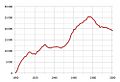
Population development in Kiruna town
-
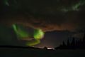
Aurora taken from the suburbs of Kiruna
-
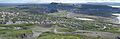
Kiruna city panorama, taken from Luossavaara, 2014


See also
 In Spanish: Kiruna para niños
