Laguna Niguel, California facts for kids
Quick facts for kids
Laguna Niguel, California
|
|||
|---|---|---|---|
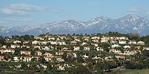
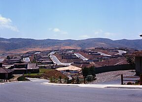
Suburban homes in Laguna Niguel, 2004
|
|||
|
|||
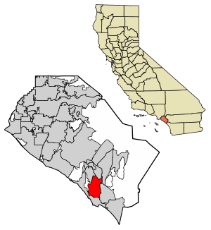
Location of Laguna Niguel in Orange County, California
|
|||
| Country | United States | ||
| State | California | ||
| County | Orange | ||
| Incorporated | December 1, 1989 | ||
| Government | |||
| • Type | Council-Manager | ||
| Area | |||
| • Total | 14.79 sq mi (38.30 km2) | ||
| • Land | 14.74 sq mi (38.17 km2) | ||
| • Water | 0.05 sq mi (0.13 km2) 0.35% | ||
| Elevation | 400 ft (122 m) | ||
| Population
(2020)
|
|||
| • Total | 64,355 | ||
| • Density | 4,351.3/sq mi (1,680.29/km2) | ||
| Time zone | UTC-8 (Pacific) | ||
| • Summer (DST) | UTC-7 (PDT) | ||
| ZIP codes |
92607, 92677
|
||
| Area code | 949 | ||
| FIPS code | 06-39248 | ||
| GNIS feature IDs | 1660875, 2411597 | ||
Laguna Niguel (/ləˈɡuːnə nɪˈɡɛl/) is a city in Orange County, California, United States. Its name comes from "Laguna," meaning "lagoon" in Spanish. "Niguili" was the name of a Native American village nearby.
As of 2020, about 64,355 people live here. Laguna Niguel is in the San Joaquin Hills in southeastern Orange County. It's close to the Pacific Ocean. The city borders Aliso Viejo, Dana Point, Laguna Beach, Laguna Hills, Mission Viejo, and San Juan Capistrano.
Laguna Niguel started as part of a large Mexican land grant called Rancho Niguel. In 1959, the Laguna Niguel Corporation bought the land. They planned one of California's first large, organized communities. It's mostly a residential city, meaning many people live here and travel to jobs in other parts of Orange County. Laguna Niguel is known for its pleasant coastal weather, low crime, and many parks and trails.
Contents
History of Laguna Niguel
Early People and Land Owners
The first people known to live in the Laguna Niguel area were the Acjachemem Native Americans. They might have had a village called "Niguili" near Aliso Creek. In the 1700s, Spanish missionaries built Mission San Juan Capistrano nearby. They wanted to convert the Acjachemem people to Christianity.
After Mexico became independent from Spain in 1821, the mission lands were divided. In 1842, Juan Avila received the 13,316-acre Rancho Niguel. He kept the land even after California became part of the United States. But a bad drought in 1865 forced him to sell.
In 1895, Lewis Moulton and Jean Pierre Daguerre bought Rancho Niguel. They used the land for orchards and sheep ranching. In 1951, the land was split between the Moulton and Daguerre families. The Daguerres got 8,056 acres, which is where Laguna Niguel is today.
Building a Planned Community
When Interstate 5 was finished in 1959, it became easier to travel to jobs in Los Angeles. This caused a big growth in housing in Orange County. In 1959, two companies, Cabot, Cabot & Forbes and Paine Webber, formed the Laguna Niguel Corporation. They bought the Daguerre land to create one of California's first master-planned communities.
The first plan for the 7,100-acre town was made by architect Victor Gruen. Later, AVCO Community Developers took over and expanded the plan. The city's name combines "Laguna" (for a tidal lagoon) and "Niguili" (the Native American village).
Laguna Niguel was designed to be a place where families could find most of their needs met within the community. The plan also focused on having lots of parks and open spaces. These areas make up almost a third of the city's land.
In 1962, the first homes were finished in Monarch Bay and Niguel Terrace. The Moulton Niguel Water District was created in 1960 to bring water from the Colorado River Aqueduct. This was important because the area didn't have enough natural water. By 1965, Laguna Niguel had 1,000 residents.
The Chet Holifield Federal Building, also known as the "Ziggurat" because of its shape, was built in 1971. It's a famous local landmark. In 1973, Laguna Niguel Regional Park opened to the public.
Becoming a City
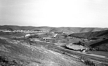
In the 1970s, the nearby area of Dana Point wanted to become a city. They were interested in including the Niguel Shores area, which was part of Laguna Niguel's development. Both areas asked to become cities in 1986. There was a disagreement about whether Monarch Beach should join Dana Point or Laguna Niguel. Even though Laguna Niguel had developed Monarch Beach, its residents voted to join Dana Point.
Laguna Niguel officially became a city on December 1, 1989. It became the 29th city in Orange County, but without the coastal Monarch Beach area.
Growth and Challenges
Laguna Niguel grew quickly in population from 1980 to 2000. By 2015, most of the city was built. In 1996, the 73 San Joaquin Hills toll road opened. This road connects Laguna Niguel to Interstate 405 in Costa Mesa. The Laguna Niguel City Hall opened on October 15, 2011.
In 1998, after heavy rains, a hillside collapsed in the Niguel Summit community. It destroyed several homes. Luckily, no one was hurt because the area had been evacuated. An investigation showed that the ground supporting the homes was not properly prepared. More recently, in 2022, a fire called the Coastal Fire damaged many homes in the Niguel Summit area.
Geography and Climate
Laguna Niguel covers about 14.9 square miles (38.3 square kilometers). Most of this is land, with a small amount of water. The city is mostly hilly, located in the San Joaquin Hills. The average height above sea level is 400 feet (122 meters). The highest point is Niguel Hill, at 936 feet (285 meters).
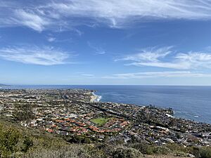
Laguna Niguel is very close to the Pacific Ocean, but it does not touch the coast. This is because of the disagreement with Dana Point when the city was formed. The main waterways are Salt Creek and Sulphur Creek. Sulphur Creek flows into Aliso Creek. Laguna Niguel Lake, formed by a dam on Sulphur Creek, is the city's largest body of water.
Weather in Laguna Niguel
| Weather chart for Laguna Niguel, California | |||||||||||||||||||||||||||||||||||||||||||||||
|---|---|---|---|---|---|---|---|---|---|---|---|---|---|---|---|---|---|---|---|---|---|---|---|---|---|---|---|---|---|---|---|---|---|---|---|---|---|---|---|---|---|---|---|---|---|---|---|
| J | F | M | A | M | J | J | A | S | O | N | D | ||||||||||||||||||||||||||||||||||||
|
2.9
68
44
|
3.4
68
45
|
2
69
47
|
0.9
72
50
|
0.3
73
54
|
0.1
75
58
|
0.1
79
61
|
0
80
60
|
0.3
80
59
|
0.7
77
54
|
1.1
72
48
|
2.4
67
43
|
||||||||||||||||||||||||||||||||||||
| temperatures in °F precipitation totals in inches source: Weather.com / NWS |
|||||||||||||||||||||||||||||||||||||||||||||||
|
Metric conversion
|
|||||||||||||||||||||||||||||||||||||||||||||||
Laguna Niguel has pleasant weather all year, like much of coastal Southern California. August is usually the hottest month, and December is the coolest. The highest temperature ever recorded was 108°F (42°C) in 1963. The lowest was 21°F (-6°C) in 1949. The city doesn't get much rain, with an average of 14.2 inches (361 mm) per year.
City Neighborhoods
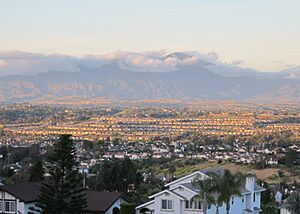
Laguna Niguel has many different neighborhoods. Some of them include Bear Brand Ranch, San Marin, Ocean Ranch, Laguna Crest, and Monarch Point. These areas often have great views of the city, canyons, and the ocean. Other neighborhoods are Rancho Niguel, Marina Hills, Kite Hill, and Rolling Hills.
Major Roads and Highways
![]() Interstate 5 runs along the eastern edge of Laguna Niguel. It forms the border with Mission Viejo.
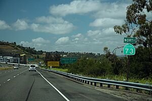
Interstate 5 runs along the eastern edge of Laguna Niguel. It forms the border with Mission Viejo. ![]() The San Joaquin Hills Transportation Corridor is a major toll road that goes through Laguna Niguel. It connects to Interstate 405 in Costa Mesa.
The San Joaquin Hills Transportation Corridor is a major toll road that goes through Laguna Niguel. It connects to Interstate 405 in Costa Mesa.
Other important roads include Alicia Parkway and Crown Valley Parkway, which run north-south. The Street of the Golden Lantern/Moulton Parkway runs east-west. These roads help people travel throughout the city.
Population and People
| Historical population | |||
|---|---|---|---|
| Census | Pop. | %± | |
| 1970 | 4,644 | — | |
| 1980 | 12,237 | 163.5% | |
| 1990 | 44,400 | 262.8% | |
| 2000 | 61,891 | 39.4% | |
| 2010 | 62,979 | 1.8% | |
| 2020 | 64,355 | 2.2% | |
| U.S. Decennial Census | |||
Laguna Niguel's Population
In 2020, Laguna Niguel had a population of 64,355 people. Most residents are White (72.6%), with 11.3% Asian and 1.9% African American. About 15.8% of the population is Hispanic or Latino.
In 2010, the population was 62,979. About 99.6% of people lived in homes. The average household had 2.59 people. Many households (58.1%) were married couples. About 22.6% of the population was under 18 years old. The median age was 42.8 years.
Laguna Niguel is a comfortable place to live. In 2009–2013, the average household income was $99,771. Only a small percentage of the population (6.3%) lived below the poverty line.
Economy and Jobs
Laguna Niguel is mainly a residential city. This means many people who live here travel to jobs in other cities like Irvine and Newport Beach. Most jobs within Laguna Niguel itself are in the service industry.

Here are some of the top employers in Laguna Niguel:
| # | Employer | # of employees |
|---|---|---|
| 1 | United States Government | 2,000 |
| 2 | Costco | 595 |
| 3 | Capistrano Unified School District | 337 |
| 4 | Walmart | 301 |
| 5 | Lifetime Fitness | 282 |
| 6 | Whole Foods Market | 256 |
| 7 | Mercedes-Benz of Laguna Niguel | 210 |
| 8 | The Home Depot | 186 |
| 9 | Albertsons | 154 |
| 10 | Vons | 141 |
Education in Laguna Niguel
The Capistrano Unified School District serves the city of Laguna Niguel.
Elementary Schools
- Moulton Elementary School
- Marian Bergeson Elementary
- Crown Valley Elementary School
- Hidden Hills Elementary School
- Laguna Niguel Elementary School
- John S. Malcom Elementary School
- George White Elementary School
- Orange County Academy of Sciences and Arts (K-8)
Middle Schools
- Niguel Hills Middle School
- Aliso Viejo Middle School (in Aliso Viejo)
- Orange County Academy of Sciences and Arts (K-8)
High Schools
- Aliso Niguel High School (in Aliso Viejo)
- Dana Hills High School (in Dana Point)
Colleges and Universities Nearby
- Saddleback College (in Mission Viejo)
- Chapman University (in Orange)
- Soka University of America (in Aliso Viejo)
- University of California, Irvine (in Irvine)
- California State University, Fullerton (in Irvine and Fullerton)
- Pepperdine University (in Irvine)
Private Schools
- St. Anne School
City Services and Transportation
Emergency Services
The Orange County Fire Authority protects Laguna Niguel. Care Ambulance Service provides ambulance services. The Orange County Sheriff provides police services. While there are no hospitals directly in Laguna Niguel, there are several nearby.
Utilities
Electricity is provided by Southern California Edison and San Diego Gas & Electric. The Moulton Niguel Water District provides water, which comes from the Colorado River Aqueduct and the State Water Project. Gas is supplied by San Diego Gas & Electric and The Gas Company.
Getting Around Laguna Niguel
Laguna Niguel has a network of main roads that connect its neighborhoods. Crown Valley Parkway is a major road that goes through the city. Other important roads include Alicia Parkway, Niguel Road, and Moulton Parkway. Because the area is hilly, the streets are not in a perfect grid pattern.
Buses and Trains
The Orange County Transportation Authority (OCTA) runs several bus routes in Laguna Niguel. Bus route 490 connects to the Metrolink train station.
The Laguna Niguel/Mission Viejo station is served by Metrolink commuter trains. These trains can take you to cities in Los Angeles, Riverside, San Bernardino, and San Diego Counties. Amtrak trains no longer stop in Laguna Niguel, but they do stop at nearby stations in Irvine and San Juan Capistrano.
Biking in the City
Most major roads in Laguna Niguel have bike lanes. There are about 60 miles (97 km) of these lanes. The city also has special bikeways that connect to its many parks.
Parks and Outdoor Spaces
Laguna Niguel is known for its many parks and trails. Over one-third of the city is public open space. This was part of the original plan for the community. There are 31 city parks and 4 county parks. The city's main roads are designed as "scenic highways" with parks and paths alongside them.
The 227-acre Laguna Niguel Regional Park is in the center of the city. It has many trails, sports courts, and Laguna Niguel Lake. The lake is a popular spot for fishing and boating. Crown Valley Park has the city's main public sports facilities.
Aliso and Wood Canyons Wilderness Park borders Laguna Niguel on the west. It has over 4,000 acres (1,600 ha) of canyons, grasslands, and forests. This park is part of a larger area called the South Coast Wilderness. This large area of preserved open space helps protect wildlife in Orange County.
Laguna Niguel has about 80 miles (129 km) of trails for hiking, biking, and horseback riding. Some popular trails include the Aliso Summit trail and the Colinas Bluff Trail. The Laguna Ridge Trail goes through Badlands County Park and up to Niguel Hill, the highest point in the city. The paved Salt Creek Trail is great for biking. The Aliso Creek Trail is also known as the "Forest to the Sea Trail." It plans to connect the Santa Ana Mountains to the Pacific Ocean.
Notable People from Laguna Niguel
- Josh Allen, quarterback for the Buffalo Bills
- Erik Apple, mixed martial arts fighter
- Gavyn Bailey, singer-songwriter
- Patricia Bates, a member of the California State Senate
- Daniel L. Fapp, cinematographer
- McKayla Maroney, 2012 Summer Olympics medalist
- Cady McClain, actress, singer and author
- Mimi Walters, a former member of the U.S. House of Representatives
- Rachel Wood, soccer player
Sister Cities
See also
 In Spanish: Laguna Niguel para niños


