
Lake Moeris facts for kids
Quick facts for kids Lake Qarun |
|
|---|---|
| Lake Moeris | |

Satellite image of the Faiyum Oasis, with Lake Qarun in its interior
|
|
| Location | Faiyum Governorate, Egypt |
| Primary inflows | Nile River (via the Bahr Yussef) |
| Basin countries | Egypt |
| Surface area | 202 km2 (78 mi2) – ancient area estimated between 1,270 km2 (490 mi2) and 1,700 km2 (660 mi2) |
| Surface elevation | 43 m (141 ft) below sea-level |
| Frozen | No |
| Settlements | Cairo, Faiyum |
Lake Qarun is a special lake in Egypt. It is about 80 kilometers (50 miles) southwest of Cairo. Long ago, it was a huge freshwater lake called Lake Moeris. It was fed by the Nile River. Over thousands of years, it has shrunk a lot. Today, it is much smaller and very salty.
In ancient times, Lake Moeris was a big part of the Faiyum Oasis. It covered a huge area, up to 1,700 square kilometers (660 square miles). The lake's water level changed a lot in prehistoric times. This was because the Nile River fed it only sometimes.
During the Middle Kingdom, people started to control the lake's water. They dug canals, like the Bahr Yussef, to bring more water from the Nile. This helped them use the land around the lake for farming. Later, during the Ptolemaic Kingdom, more changes were made. A dam was built to control the Nile's flow into the lake. This caused the lake to start shrinking. It slowly became the salty Lake Qarun we see today. Its surface is now 43 meters (141 feet) below sea level. It covers about 202 square kilometers (78 square miles).
Lake Qarun is an important place for many water birds. These birds fly from colder places to spend the winter here. Because of this, the lake and its area are now a protected zone in Egypt. The lake's high saltiness means most freshwater fish from the Nile can't live there. But some saltwater fish have been put into the lake. This helps the local fishing industry. Fish like tilapia, mullet, and sole are caught here. In 2012, Lake Qarun was named a Ramsar site. This means it is an important wetland for birds and nature.
Lake Moeris also gave its name to an extinct animal called Moeritherium. This animal was a very old relative of modern elephants. Its fossils were found nearby.
Contents
What's in a Name?
The name "Lake Moeris" comes from the Greek words for "Great Canal." This likely refers to the Bahr Yussef canal. The pharaoh who built this canal, Amenemhat III, was even called "King Moeris" by the Greeks.
Later, in ancient Egyptian, the lake was called Piôm. This means "the Sea." This name changed over time. It became epʰiom or peiom in Coptic. From these words, we get the modern Arabic name الفيوم (el-Fayyūm). This is where the name Faiyum comes from today.
How Lake Moeris Changed Over Time
Early History and Human Life
Long, long ago, before humans lived there, the Nile River flowed past the Faiyum area. This was during a time when the Mediterranean Sea was almost dry. The Nile carved a very deep canyon. Later, the Mediterranean Sea refilled. The Nile canyon became a long arm of the sea. Over time, the Nile filled this arm with mud and dirt. This created the Nile valley.
Eventually, the Nile's floods started to flow into the Faiyum basin. This created the first Lake Moeris. This early lake was fed only by floods. It sometimes dried up completely. But it always came back. People lived near Lake Moeris even in the Stone Age. Tools found there show that humans were present.
Building and Farming in Ancient Egypt
Around 3000 BCE, a town called Shedet grew on the lake's bank. This town became important for the Egyptian god Sobek, who was linked to crocodiles. The Greeks later called the city Crocodilopolis, or "Crocodile City." The modern city of Faiyum is built on this ancient site.
The kings of the Twelfth Dynasty made big changes to Lake Moeris. They started projects to drain parts of the lake. This created new land for farming. Amenemhat III ordered a huge digging project. This created the Bahr Yussef canal. This canal brought much more water from the Nile to the lake. It helped turn the Faiyum area into a major farming region.
The lake was also used for transport. Huge stone blocks were taken from a nearby quarry. They were moved to the lake using the Lake Moeris Quarry Road. This was the oldest known paved road in the world! From the lake, the blocks could be shipped to the Giza Necropolis. They were used to build temples and monuments. This road is now a Historic Civil Engineering Landmark.
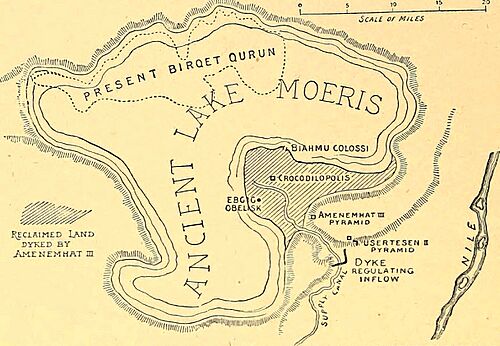

The Greek historian Herodotus wrote about visiting Lake Moeris. He said two "pyramids" stood in the middle of the lake. These were likely the Pedestals of Biahmu. Some thought the lake was flooded when he visited. The huge water projects made by the ancient Egyptians made people think the lake was completely man-made. But we now know it was a natural lake that was changed by humans.
Later Changes: Greeks and Romans
After Alexander the Great died, Egypt was ruled by the Ptolemaic dynasty. These Greek rulers continued to develop the Faiyum area. They wanted to make it an even bigger farming center. Ptolemy II Philadelphus built more canals and dams. A dam on the Bahr Yussef helped control the Nile's water flow. This allowed more people to settle in the area. It also helped grow more grain. As the lake's water went down, new fertile land appeared. This dam also started the lake's slow shrinking.
By the end of the Ptolemaic rule, the irrigation system was not well maintained. This caused farms in Faiyum to dry up or flood. When Rome took over Egypt, the Roman emperor Augustus fixed the lake's water system. This helped Egypt become a major food supplier for the Roman Empire. Farming in Faiyum thrived again. But over time, the systems were neglected again. The Roman settlements became empty. By the 5th century, most of the area was abandoned. Only a small part remained farmed through the Middle Ages.
Wildlife and Fishing in Lake Qarun

Today, Lake Qarun is a home for almost 88 different kinds of water birds. Many birds come here to breed. These include Collared pratincoles and different types of plovers. Other birds, like black-necked and great crested grebes, come from Europe and Asia for the winter. Many types of ducks also visit. Because it is so important for birds, Lake Qarun is a protected area. It is also a Ramsar site, which means it's a wetland of international importance.

The lake is getting saltier and cloudier. This has caused most of the original freshwater fish from the Nile to disappear. To help the local fishing industry, many saltwater fish have been put into the lake. These include different kinds of mullet and prawn. Tilapia, mullet, and sole are the main fish caught in Lake Qarun today. However, fishing has decreased a lot. This is due to the lake shrinking, more pollution from farms, and tiny creatures called isopods that harm the fish.
