Laurel Run (Huntington Creek tributary) facts for kids
Quick facts for kids Laurel Run |
|
|---|---|

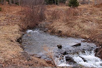
Laurel Run looking upstream
|
|
| Other name(s) | Laurel Run Creek |
| Physical characteristics | |
| Main source | valley in Ross Township, Luzerne County, Pennsylvania between 1,300 and 1,320 feet (400 and 400 m) |
| River mouth | Huntington Creek in Ross Township, Luzerne County, Pennsylvania 1,043 ft (318 m) 41°17′21″N 76°10′13″W / 41.28912°N 76.17035°W |
| Length | 1.8 mi (2.9 km) |
| Basin features | |
| Progression | Huntington Creek → Fishing Creek → Susquehanna River → Chesapeake Bay |
| Basin size | 1.29 sq mi (3.3 km2) |
Laurel Run (also known as Laurel Run Creek) is a small stream in Luzerne County, Pennsylvania, in the United States. It is a tributary, which means it flows into a larger stream called Huntington Creek. Laurel Run is about 1.8 miles (2.9 km) long and flows through Ross Township.
The area of land that drains into Laurel Run is called its watershed, and it covers about 1.29 square miles (3.34 km2). This stream is quite special because wild trout naturally live and reproduce in its waters. It's even called a "Least Disturbed Stream," which means it's very clean and healthy!
Contents
Where Does Laurel Run Flow?
Laurel Run starts in a valley in Ross Township. It flows towards the west-southwest for almost a mile, running next to Dobson Road. Then, it turns to the southwest for a short distance. After that, the stream turns west-southwest again for a few tenths of a mile. Finally, it crosses State Route 4024 and joins Huntington Creek.
Laurel Run meets Huntington Creek about 22.82 miles (36.72 km) upstream from where Huntington Creek ends.
Land and Rocks Around Laurel Run
The land around the end of Laurel Run is about 1,043 feet (318 m) above sea level. Where the stream begins, its source, the elevation is higher, between 1,300 and 1,320 feet (396 and 402 m) above sea level.
Laurel Run is located in a region called the Susquehanna Lowlands. This area is part of the Ridge-and-Valley Appalachians, which is a large region known for its long, parallel ridges and valleys.
Most of the ground around Laurel Run is covered by a type of soil called Wisconsinan Till. This is a mix of rock, sand, and clay left behind by glaciers. On the sides of the valley, you can find solid bedrock made of sandstone and shale. Near where Laurel Run joins Huntington Creek, the ground has something called Wisconsinan Ice-Contact Stratified Drift. This material was also left by glaciers and contains layers of sand and gravel, along with some large boulders.
Laurel Run's Watershed
The watershed of Laurel Run is the entire area of land where all the rain and snowmelt eventually flow into this stream. It covers about 1.29 square miles (3.34 km2). The stream is entirely within a specific map area called the Sweet Valley quadrangle, as defined by the United States Geological Survey.
Laurel Run is officially known as a "Least Disturbed Stream" by the Pennsylvania Natural Heritage Program. This means it's a very high-quality stream that hasn't been changed much by people. It works like a natural stream should, which is great for the environment!
Most of the land in Laurel Run's watershed is covered by forests, more than 75 percent. Less than 0.75 percent of the land is developed (like buildings or roads), and less than 32.5 percent is used for farming. The area right along the stream, called the riparian buffer, is also mostly forested (over 80 percent). This helps keep the water clean.
There are no dams on Laurel Run, and no point-source pollution (pollution coming from a single pipe or drain) has been found in its watershed. There are also very few road crossings over the stream, which helps keep it natural.
A Bit of History
Laurel Run was officially added to the Geographic Names Information System on August 2, 1979. This system helps keep track of names and locations of geographical features.
Back in the early 1900s, the local government in Luzerne County, the Commissioners, asked for permission to build a bridge over Laurel Run. This bridge was planned to be a strong concrete bridge on the road that connected Mooretown to Sweet Valley.
Wildlife in Laurel Run
One of the most exciting things about Laurel Run is its wildlife! Wild trout naturally live and reproduce in the stream. This means they lay their eggs and new trout are born right there in the stream, from its very beginning (its headwaters) all the way to where it joins Huntington Creek. This shows how clean and healthy the water in Laurel Run is.
 | Sharif Bey |
 | Hale Woodruff |
 | Richmond Barthé |
 | Purvis Young |

