Lawndale, California facts for kids
Quick facts for kids
Lawndale, California
|
|||
|---|---|---|---|

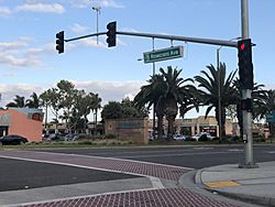
Intersection of Rosecrans Ave. and Hawthorne Blvd.
|
|||
|
|||
| Motto(s):
"Heart of the South Bay"
|
|||

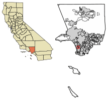
Location of Lawndale in Los Angeles County, California.
|
|||
| Country | |||
| State | |||
| County | Los Angeles | ||
| Incorporated | December 28, 1959 | ||
| Area | |||
| • Total | 1.97 sq mi (5.11 km2) | ||
| • Land | 1.97 sq mi (5.11 km2) | ||
| • Water | 0.00 sq mi (0.00 km2) 0% | ||
| Elevation | 59 ft (18 m) | ||
| Population
(2020)
|
|||
| • Total | 31,807 | ||
| • Density | 16,406.5/sq mi (6,334.58/km2) | ||
| Time zone | UTC-8 (PST) | ||
| • Summer (DST) | UTC-7 (PDT) | ||
| ZIP codes |
90260, 90261
|
||
| Area code(s) | 310/424 | ||
| FIPS code | 06-40886 | ||
| GNIS feature IDs | 1652742. 2411637 | ||
Lawndale is a city in Los Angeles County, California, United States. It is part of the South Bay area, which is a region within the larger Greater Los Angeles Area. In 2020, about 31,807 people lived here.
Contents
History of Lawndale
Early Days and Spanish Land Grants
Long ago, the Tongva tribe, a group of Native Americans, lived in the area that is now Lawndale. Later, in the 1780s, the Spanish colonial government gave out large pieces of land called Rancho Sausal Redondo. Much of what is now Lawndale was part of this big land grant.
In 1905, a man named Charles B. Hopper divided the land into smaller plots. He named the area Lawndale, after a neighborhood in Chicago. At first, the land sold slowly. People tried different ways to attract buyers, like promoting Lawndale as a good place to raise chickens.
Transportation and Growth
The first train line in Lawndale was the Inglewood Division of the Redondo Railway. This line later became part of the famous Pacific Electric "Red Car" system. It ran along what is now Hawthorne Boulevard until 1933. In 1927, the Santa Fe railroad also came to Lawndale.
After World War II, many soldiers came home and needed places to live. There was a huge demand for housing in California. This led to Lawndale growing into a "bedroom community," meaning many people lived there and traveled to other cities for work. Lawndale officially became a city on December 28, 1959.
Changes and Modern Improvements
Starting in the 1970s, Lawndale's housing prices were lower than nearby cities. This attracted many renters. In the 1980s, some young people who worked in the defense industry moved to Lawndale because they couldn't afford to live closer to the beach.
After the Cold War, the defense industry slowed down. Lawndale then focused on attracting more people who would own their homes. The city also worked to make the area more appealing to visitors. In 2003, the "Beautify Lawndale" project improved Hawthorne Boulevard, a main road in the South Bay.
In 2004, a large electronic billboard was put up. It shows advertisements and helps the city earn money. In 2012, the Lawndale community center opened, providing a place for residents to gather.
Economy and Jobs
Lawndale has several important employers. These are the companies and organizations that provide the most jobs in the city.
Major Employers in Lawndale
According to a 2022 report, here are some of the top employers:
| # | Employer | # of Employees |
|---|---|---|
| 1 | Lawndale Elementary School District | 779 |
| 2 | Centinela Union Valley High School District | 525 |
| 3 | Target | 78 |
| 4 | VCA Advanced Veterinary Care Center | 75 |
| 5 | El Super Grocery Store | 72 |
| 6 | McDonald's | 70 |
| 7 | City of Lawndale | 65 |
| 8 | Options for Life, Inc. | 50 |
| 9 | Smart and Final | 42 |
| 10 | American Drilling Co | 40 |
Local Media
Lawndale has its own ways of keeping residents informed.
Television and News
- Lawndale Community Cable Television: This is a local TV station on Channel 22. It is funded by fees from local cable companies and helps create community programs.
- The Lawndalian: This is a newsletter for the city. It tells residents about events and programs. You can also find it online on the city's website.
- The Lawndale Tribune: This is the local newspaper for Lawndale.
City Services and Infrastructure
Lawndale provides many services to its residents.
Public Safety and Health
- Sheriff's Department: The Los Angeles County Sheriff's Department (LASD) helps keep Lawndale safe. They have a service center in the city.
- Health Services: The Los Angeles County Department of Health Services operates the Curtis Tucker Health Center in nearby Inglewood, which serves Lawndale residents.
Postal and Library Services
- Post Office: The United States Postal Service has a Lawndale Post Office on Marine Avenue.
- Public Library: The County of Los Angeles Public Library has a branch in Lawndale. It is located next to the City Hall and was renovated in 2009.
Education in Lawndale
Lawndale has several schools for students of all ages.
Elementary and Middle Schools
The Lawndale Elementary School District includes:
- Will Rogers Middle School (grades 6-8)
- Jane Addams Middle School (grades 6-8)
- F.D.R. Elementary School
- William Anderson Elementary School
- William Green Elementary School
- Mark Twain Elementary School
- Billy Mitchell Elementary School
- Lucille J. Smith Elementary School
High Schools
The Centinela Valley Union High School District serves older students:
- Lawndale High School
- Leuzinger High School
- Hawthorne High School
- Lloyde High School
There is also Environmental Charter High School, which is a special type of public school for grades 9 through 12.
Geography and Climate
Lawndale is a small city, covering about 2.0 square miles (5.1 square kilometers) of land.
Location and Nearby Cities
Lawndale is surrounded by other cities:
- To the west and southwest is Redondo Beach.
- To the north is Hawthorne.
- To the southeast is Torrance.
- To the east is El Camino Village, which is an unincorporated area (meaning it's not part of a city).
Transportation Routes
Major roads and highways serve Lawndale:
- Interstate 405 (a major freeway)
- Hawthorne Boulevard (State Route 107)
- Artesia Boulevard (State Route 91)
Lawndale is also about 5.7 miles southeast of Los Angeles International Airport.
Public Transportation
You can get around Lawndale using public transit:
- The Lawndale Beat bus (currently suspended).
- Gardena Bus 1.
- Metro Green Line (a train line).
- Metro buses 211, 40, and 740.
Weather
The weather in Lawndale is warm all year. Winters usually have some moderate rain. Because Lawndale is close to the Palos Verdes Peninsula and the beach, it often experiences the "marine layer." This means it gets similar cool, misty weather to nearby beach cities like Manhattan Beach and El Segundo.
Population Facts
| Historical population | |||
|---|---|---|---|
| Census | Pop. | %± | |
| 1930 | 3,119 | — | |
| 1940 | 2,885 | −7.5% | |
| 1950 | 4,364 | 51.3% | |
| 1960 | 16,058 | 268.0% | |
| 1970 | 24,825 | 54.6% | |
| 1980 | 23,460 | −5.5% | |
| 1990 | 27,331 | 16.5% | |
| 2000 | 31,711 | 16.0% | |
| 2010 | 32,769 | 3.3% | |
| 2020 | 31,807 | −2.9% | |
| U.S. Decennial Census | |||
In 2010, Lawndale had a population of 32,769 people. About 61% of the population was Hispanic or Latino. The average household had about 3.37 people. Many families with children live in Lawndale.
The median age in Lawndale in 2010 was 31.9 years old. This means half the people were younger than 31.9, and half were older.
The city also helps its older residents. For example, Lawndale offers free bus trips for seniors on its city bus, the Lawndale Beat. There are also programs like "meals on wheels" and a seniors travel club.
Famous People from Lawndale
Some well-known individuals have connections to Lawndale:
- Fred Dryer: A former NFL player and actor who grew up in Lawndale and went to Lawndale High School.
- Russell Westbrook: An NBA basketball player who attended high school in Lawndale at Leuzinger High School.
- Traci Lords: An actress.
- Roy Rogers: A famous actor and singer known for his Western movies and TV shows.
- Tiran Porter: A bass player for the bands Doobie Brothers and Moby Grape. He grew up in Lawndale and went to Leuzinger High School.
Sister Cities
Lawndale has a special connection with another city in the world:
 Cagayan de Oro, Philippines (since 1986)
See also
 In Spanish: Lawndale (California) para niños
 | DeHart Hubbard |
 | Wilma Rudolph |
 | Jesse Owens |
 | Jackie Joyner-Kersee |
 | Major Taylor |


