
Lee County, Alabama facts for kids
Quick facts for kids
Lee County
|
||
|---|---|---|
.jpg)
Main façade of Lee Courthouse, 2009
|
||
|
||
| Motto(s):
"The Heart of Dixie"
|
||

Location within the U.S. state of Alabama
|
||
 Alabama's location within the U.S. |
||
| Country | ||
| State | ||
| Founded | December 5, 1866 | |
| Named for | General Robert E. Lee | |
| Seat | Opelika | |
| Largest city | Auburn | |
| Area | ||
| • Total | 616 sq mi (1,600 km2) | |
| • Land | 608 sq mi (1,570 km2) | |
| • Water | 8.3 sq mi (21 km2) 1.3% | |
| Population
(2020)
|
||
| • Total | 174,241 | |
| • Estimate
(2023)
|
183,215 |
|
| • Density | 282.86/sq mi (109.21/km2) | |
| Time zone | UTC−6 (Central) | |
| • Summer (DST) | UTC−5 (CDT) | |
| Congressional district | 3rd | |
|
||

Lee County is a place in east central Alabama. In 2020, about 174,241 people lived there. The main town, or county seat, is Opelika. The biggest city is Auburn.
The county was started in 1866. It is named after General Robert E. Lee (1807–1870). He was a famous general during the American Civil War. Lee County is part of a larger area called the Auburn-Opelika Metropolitan Statistical Area.
Contents
History of Lee County
How Lee County Started
The Alabama State Legislature, which is like Alabama's law-making group, created Lee County on December 5, 1866. It was made from parts of four other counties: Macon, Tallapoosa, Chambers, and Russell.
People in the county voted to choose their main town. Opelika was chosen as the county seat. It won against Auburn and Salem.
Changes in the 1900s
In 1923, two towns, Phenix City and Girard, joined together. Phenix City was in Lee County, and Girard was in Russell County. To make things simpler, Lee County gave about 10 square miles of land to Russell County. This land was around Phenix City.
In return, Lee County received about 20 square miles from Russell County. This new land was in the northwest part of Russell County, near a community called Marvyn. This trade of land created the southern "panhandle" shape of Lee County today. Even after this change, parts of Phenix City still stretch into Lee County.
Recent Events in the 2000s
On March 3, 2019, several strong tornadoes hit Lee County. Sadly, 23 people lost their lives, and many others were hurt. These deaths and injuries happened in the community of Beauregard. This area is southeast of the main cities of Auburn and Opelika.
Geography of Lee County
Lee County covers a total area of about 616 square miles. Most of this, about 608 square miles, is land. The remaining 8.3 square miles, or 1.3%, is water.
The county sits on a special line called the fall line. This line divides two different types of land. To the north is the Piedmont region, which has more hills. To the south is the Gulf coastal plain, which is flatter. So, the northern parts of Lee County are hillier than the southern parts.
Main Roads and Highways
 Interstate 85
 U.S. Highway 29
 U.S. Highway 80
 U.S. Highway 280
 U.S. Highway 431
 State Route 14
 State Route 51
 State Route 147
 State Route 169
Neighboring Counties
Lee County shares borders with these other counties:
- Chambers County (north)
- Harris County, Georgia (northeast)
- Muscogee County, Georgia (east)
- Russell County (south)
- Macon County (southwest)
- Tallapoosa County (northwest)
Railroad Lines
- CSX A&WP Subdivision
- Norfolk Southern Central of Georgia District
Population of Lee County
| Historical population | |||
|---|---|---|---|
| Census | Pop. | %± | |
| 1870 | 21,750 | — | |
| 1880 | 27,262 | 25.3% | |
| 1890 | 28,694 | 5.3% | |
| 1900 | 31,826 | 10.9% | |
| 1910 | 32,867 | 3.3% | |
| 1920 | 32,821 | −0.1% | |
| 1930 | 36,063 | 9.9% | |
| 1940 | 36,455 | 1.1% | |
| 1950 | 45,073 | 23.6% | |
| 1960 | 49,754 | 10.4% | |
| 1970 | 61,268 | 23.1% | |
| 1980 | 76,283 | 24.5% | |
| 1990 | 87,146 | 14.2% | |
| 2000 | 115,092 | 32.1% | |
| 2010 | 140,247 | 21.9% | |
| 2020 | 174,241 | 24.2% | |
| 2023 (est.) | 183,215 | 30.6% | |
| U.S. Decennial Census 1790–1960 1900–1990 1990–2000 2010–2020 |
|||
In 2020, the census counted 174,241 people living in Lee County. There were about 68,728 households, which are groups of people living together. The average number of people per household was 2.44.
The population of Lee County has grown a lot over the years. In 2010, there were 140,247 people. By 2020, this number had increased to 174,241.
The people living in Lee County come from many different backgrounds. In 2020, about 63% of the people were White, and about 22.5% were Black or African American. There were also growing numbers of Asian people and people of Hispanic or Latino background.
Education in Lee County
Lee County is home to two important schools. One is Auburn University, a large public university where students can earn many different degrees. The other is Southern Union State Community College, which offers two-year degrees and technical training.
Communities in Lee County


Cities in Lee County
- Auburn
- Opelika (This is the county seat, where the main government offices are.)
- Phenix City (Part of this city is also in Russell County.)
- Smiths Station
Towns in Lee County
- Loachapoka
- Notasulga (Part of this town is also in Macon County.)
- Waverly (Part of this town is also in Chambers County.)
Smaller Communities (Unincorporated)
These are smaller places that are not officially cities or towns:
- Beans Mill
- Beauregard
- Bee Hive
- Beulah
- Chewacla
- Gold Hill
- Hopewell
- Marvyn
- Roxana
- Salem
- The Bottle
Places to Visit in Lee County
Lee County has many interesting places to explore:
- The Auburn University Museum of Natural History
- Chewacla State Park, a great place for outdoor activities
- The Jule Collins Smith Museum of Fine Art, which has many beautiful artworks
- Bean's Mill
- The historic Salem-Shotwell Covered Bridge
- The Grand National Golf course, which is part of the Robert Trent Jones Golf Trail
Gallery
-
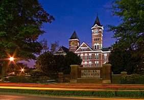
Samford Hall at the Auburn University, 2008.
-
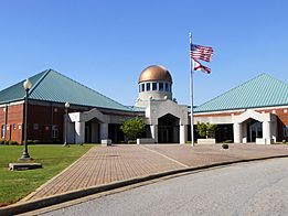
Southern Union SCC's Opelika Campus, 2011.
-
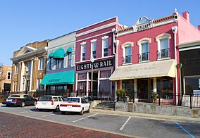
Opelika's Historic Railroad Avenue, 2011.
-
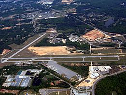
Auburn University Regional Airport, 2007.


See also
 In Spanish: Condado de Lee (Alabama) para niños
