
National Register of Historic Places listings in Burlington County, New Jersey facts for kids

Burlington County, New Jersey, is a place rich in history! Many buildings, areas, and even archaeological sites here are so important that they are listed on the National Register of Historic Places. This special list is managed by the United States government to help protect and celebrate places that tell us about America's past.
Think of it like a Hall of Fame for historic sites! When a place is on this list, it means it has a unique story to tell about our country's history, architecture, or culture. These sites help us understand how people lived, worked, and built communities long ago. Let's explore some of these amazing historic treasures in Burlington County!
Contents
- Historic Homes and Farms
- Historic Villages and Districts
- Schools and Meetinghouses
- William R. Allen School
- Arney's Mount Friends Meetinghouse and Burial Ground
- Birmingham School
- Main Street Friends Meeting House
- Moorestown Friends School and Meetinghouse
- New Jersey Manual Training and Industrial School for Colored Youth
- Old Schoolhouse (Mount Holly)
- Quaker School (Burlington)
- Springside Public School
- Other Unique Historic Sites
- Images for kids
Historic Homes and Farms
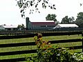
Many old homes and farms in Burlington County have been preserved because they show us how people lived centuries ago.
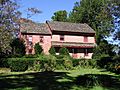
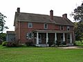
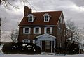
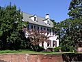
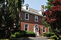
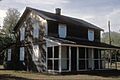
Francis Hopkinson House
.jpg)
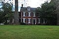
The Francis Hopkinson House in Bordentown is a very special place. Francis Hopkinson was one of the people who signed the Declaration of Independence! He was also a talented artist, writer, and even designed the first official American flag. His home, built in the 18th century, helps us imagine what life was like for a Founding Father. It was listed on the National Register in 1971.
Alice Paul Birthplace

In Mount Laurel Township, you can find the Alice Paul Birthplace, also known as Paulsdale. Alice Paul was a brave and important leader in the fight for women's right to vote, known as the suffrage movement. She worked tirelessly to make sure women had the same rights as men. Her home became a historic landmark in 1989.
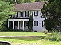
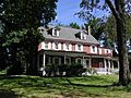
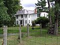
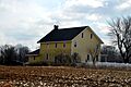
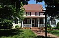
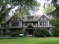
Other Notable Homes
- Breidenhart (1977): Located in Moorestown Township, this historic home at 255 East Main Street is a beautiful example of older architecture.
- Thomas French, Jr., House (1978): Also in Moorestown Township, this house at 512 Camden Avenue shows us how families lived in the late 18th century.
- John Irick House (1977): East of Burlington, this house gives us a peek into the past of rural Burlington County.
- Ivins-Conover House (1977): North of Moorestown, this house on Cox Road is another example of the region's historic homes.
- Benjamin Jones House (1982): In Pemberton, this house on Pemberton-Browns Mills Road is a well-preserved piece of local history.
- Smith Mansion (1976): Found at 12 High Street in Moorestown Township, this grand home reflects the style of the late 19th century.
- Thomas Smith House (1990): At 1645 Hainesport-Mt. Laurel Road in Mount Laurel Township, this house is a significant local landmark.
- Charles Stokes House (1993): Located at 600 Beverly-Rancocas Road in Willingboro Township, this house contributes to the area's historical character.
- Stokes-Evans House (1994): At 52 East Main Street in Marlton, this house is part of the rich history of Evesham Township.
- Taylor-Newbold House (1988): Off Old York Road in Chesterfield Township, this house is a great example of historic farm architecture.
- Jacob Wills House (1990): On Brick Road, west of Evans Road in Evesham Township, this house showcases the area's agricultural past.
- Zurbrugg Mansion (2009): Located at 531 Delaware Avenue in Delanco, this mansion is a grand example of early 20th-century design.
Historic Villages and Districts
Some entire areas or villages are listed because they have many historic buildings that together tell a story.
Atsion Village

Atsion Village (1974) is located along US 206. This village was once a busy iron-making community in the 18th and 19th centuries. It's like stepping back in time to see how people lived and worked in a small industrial town.
Batsto Village

Batsto Village (1971), about 10 miles east of Hammonton, is another amazing historic village. It was also an iron-making town and later a glass-making center. Today, it's a preserved village where you can explore old homes, a general store, and a gristmill, imagining life from long ago.
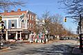
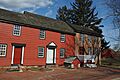
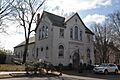
Bordentown Historic District

The Bordentown Historic District (1982) covers a large part of Bordentown. This district is full of historic buildings, including homes, churches, and schools, that show the town's long and important history, especially its role in early American development.
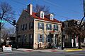
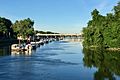
Burlington Historic District

The Burlington Historic District (1975) in Burlington is roughly shaped like an "L" and includes many historic streets and buildings near the Delaware River. Burlington was one of the earliest settlements in New Jersey, and this district preserves its colonial and early American charm.
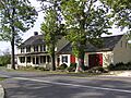
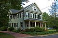
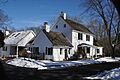
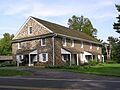
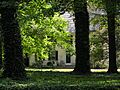
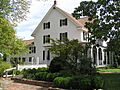
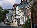
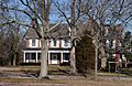
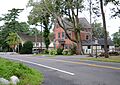
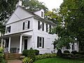
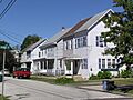
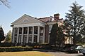
Moorestown Historic District
.JPG)
The Moorestown Historic District (1990) in Moorestown Township is a beautiful area with many well-preserved buildings. It shows the growth and development of a charming American town over centuries.
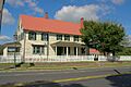
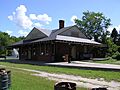
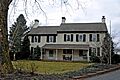
Pemberton Historic District
.JPG)
The Pemberton Historic District (1989) in Pemberton includes many historic buildings along Budd Avenue and near the Rancocas Creek. It gives us a glimpse into the town's past as a bustling community.
Roebling Historic District

The Roebling Historic District (1978) in Roebling is unique because it was a planned industrial town built by the Roebling family, famous for building the Brooklyn Bridge. This district shows how a company created a whole town for its workers, with homes, shops, and community buildings.
Schools and Meetinghouses
Many historic schools and meetinghouses are on the list, showing the importance of education and community gatherings in the past.
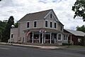
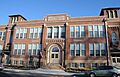
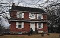
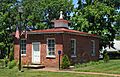
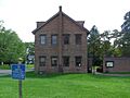
William R. Allen School

The William R. Allen School (1991) in Burlington is an important historic school building. It reminds us of how education has changed over the years and the efforts made to provide schooling for children in the past.
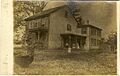
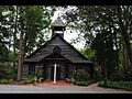
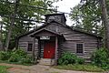
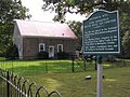
Arney's Mount Friends Meetinghouse and Burial Ground
.JPG)
The Arney's Mount Friends Meetinghouse and Burial Ground (1973) is a historic Quaker meetinghouse in Arney's Mount. Quaker meetinghouses are simple buildings where Quakers gather for worship. This site also includes a burial ground, telling stories of early settlers.
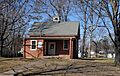
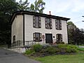
Birmingham School
.JPG)
The Birmingham School (1992) in Birmingham was a historic school building. Sadly, it was destroyed by fire in 1993. Even though it's gone, its listing reminds us of its past importance to the community.
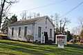
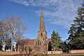
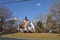
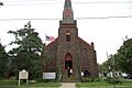
Main Street Friends Meeting House

The Main Street Friends Meeting House (2011) in Medford is another significant Quaker meeting place. These buildings are often simple but hold deep historical and community value.
Moorestown Friends School and Meetinghouse
.JPG)
The Moorestown Friends School and Meetinghouse (1988) in Moorestown Township is a place where education and faith have been connected for a long time. It shows the Quaker tradition of valuing both learning and spiritual community.
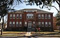
New Jersey Manual Training and Industrial School for Colored Youth

The New Jersey Manual Training and Industrial School for Colored Youth (1998), also known as the Bordentown School, was an important school in Bordentown. It provided education and vocational training for African American youth during a time when opportunities were limited. It played a vital role in civil rights history.
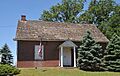
Old Schoolhouse (Mount Holly)

The Old Schoolhouse (2008) at 35 Brainerd Street in Mount Holly Township is a charming old building that once served as a school. It helps us imagine what classrooms were like for students many years ago.
Quaker School (Burlington)

The Quaker School (1974) at York and Penn Streets in Burlington is another example of early educational buildings. It highlights the Quaker community's commitment to educating their children.
Springside Public School

The Springside Public School (2015) at 1508 Mount Holly Road in Burlington Township is a more recent addition to the list, showing that important history continues to be made and recognized.
Other Unique Historic Sites
Burlington County also has some very unique historic places that don't fit neatly into other categories.
Abbott Farm Archeological Site

The Abbott Farm Archeological Site (1976) is a very old and important place in the Hamilton-Trenton-Bordentown Marsh. It's an archaeological site, meaning scientists have found evidence of ancient human life here, dating back thousands of years. It helps us understand the earliest inhabitants of New Jersey.
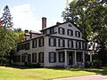
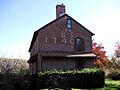
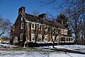
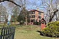
Burlington County Prison
.jpg)
The Burlington County Prison (1986) on High Street in Mount Holly Township is a fascinating historic building. It was designed in the 19th century and operated as a prison for many years. Today, it's a museum where you can learn about its history and the justice system of the past.
Hanover Furnace
.JPG)
Hanover Furnace (1974) near Browns Mills was an important iron furnace. In the 18th and 19th centuries, places like this were crucial for making iron, which was used for tools, cannons, and many other things needed for daily life and even wars.
Kirby's Mill
.JPG)
Kirby's Mill (1971) northeast of Medford is a historic gristmill. Gristmills were essential for grinding grain into flour, a basic food item for early communities. This mill shows us how people processed food before modern factories existed.
Log Cabin Lodge

The Log Cabin Lodge (1982) in Medford Lakes was a unique building. Although the original burned down in 1998, its listing as a historic place remembers its importance as a lodge or inn.
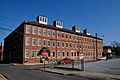
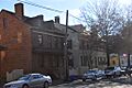
Philadelphia Watch Case Company Building

The Philadelphia Watch Case Company Building (1978) in Riverside Township is a great example of industrial history. This building was once a factory where watch cases were made, showing the manufacturing heritage of the area.
Point Breeze

Point Breeze (1977) in Bordentown was the grand estate of Joseph Bonaparte, who was the older brother of Napoleon Bonaparte, the famous French emperor! Joseph lived here after Napoleon's fall. It's a fascinating link to European royalty in New Jersey.
Red Dragon Canoe Club

The Red Dragon Canoe Club (2001) at 221 Edgewater Avenue in Edgewater Park Township is a historic club building. It represents the history of recreational activities and community life along the water.
Shamong Hotel

The Shamong Hotel (1979) on Main Street in Chatsworth is a historic hotel. Hotels like this were important stops for travelers and centers for community gatherings in the past.
Dr. James Still Office
.JPG)
The Dr. James Still Office (1995) at 209 Church Road in Medford belonged to a remarkable self-taught doctor known as the "Black Doctor of the Pines." Dr. Still was a respected healer in the 19th century, and his office is a testament to his legacy and contributions to medicine.
Images for kids
-
Arneytown Historic District
-
Bishop-Irick Farmstead
-
J. F. Budd Baby Shoe Factory
-
Burlington's Lost Burial Ground
-
Buzby's General Store
-
Chesterford School
-
Cinnaminson Avenue and Spring Garden Street Schools
-
Isaac Collins House
-
Coopertown Meetinghouse
-
Cropwell Friends Meeting House
-
Crosswicks Historic District
-
Crosswicks Creek Site III
-
Eayres Plantation and Mill Site
-
Amos Evans House
-
William and Susan Evans House
-
Evans-Cooper House
-
Thomas and Mary Evens House
-
Evesham Friends Meeting House
-
Farmer's Hall
-
Fenwick Manor
-
Florence Public School No. 1
-
Thomas French, Jr., House
-
Gen. Edward S. Godfrey House
-
Green Hill Farm
-
Jonathan Haines House
-
High Street Historic District
-
Thomas Hollinshead House
-
James and Charles B. Holloway Farm Complex
-
John Inskeep Homestead
-
Ivins-Conover House
-
Jacob's Chapel A.M.E. Church
-
Benjamin Jones House
-
Morris Mansion and Mill
-
Mount Holly Historic District
-
New St. Mary's Episcopal Church
-
Barzillai Newbold House
-
William and Susannah Newbold House
-
North Pemberton Railroad Station
-
Peachfield
-
Pearson-How, Cooper, and Lawrence Houses
-
Perkins House
-
The Protestant Community Church of Medford Lakes
-
Providence Presbyterian Church of Bustleton
-
Rancocas Historic Village
-
Recklesstown
-
William Ridgeway House
-
Riverton Historic District
-
Rosebud Farm
-
Schoolhouse (Bridgeboro)
-
Singleton-Lathem-Large House
-
Smith Mansion
-
Thomas Smith House
-
Smithville Historic District
-
St. Mary of the Lakes Catholic Church
-
St. Stephen's Episcopal Church
-
Charles Stokes House
-
Town Hall (Moorestown)
-
Upper Springfield Meetinghouse
-
Vincentown Historic District
-
West Hill
-
Whitesbog Historic District
-

Jacob Wills House
-
Zurbrugg Mansion

.JPG)


.JPG)
.JPG)
.JPG)
.JPG)
.JPG)
.JPG)

.JPG)


.JPG)


.JPG)
.JPG)


.JPG)


.JPG)

.JPG)


.JPG)
.JPG)


