
National Register of Historic Places listings in Cape May County, New Jersey facts for kids

Cape May County, New Jersey, is a special place with many old buildings and sites that tell stories about the past. These important places are listed on the National Register of Historic Places. This list helps protect them so future generations can learn from and enjoy them. Think of it like a hall of fame for historic buildings and areas!
Contents
What is the National Register of Historic Places?
The National Register of Historic Places is the official list of places in the United States that are worth saving. These places can be buildings, structures, objects, sites, or even entire neighborhoods. They are chosen because they are important to American history, architecture, archaeology, engineering, or culture.
When a place is added to the National Register, it means it's recognized as a significant part of our heritage. This recognition can help protect it from being torn down or changed too much. It also encourages people to learn about and appreciate these historic treasures.
Historic Buildings in Cape May County
Cape May County has many fascinating places on the National Register. Let's explore some of them!
Lighthouses and Life-Saving Stations
Lighthouses and life-saving stations were super important for sailors and people living by the sea. They helped guide ships safely and rescued people in trouble.
- Avalon Life Saving Station: Built in 1894, this station in Avalon was once a busy place where brave crews helped ships and people in danger along the coast. It's a reminder of the vital work of the U.S. Life-Saving Service.
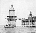
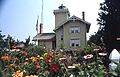
- Brandywine Shoal Light Station: This lighthouse is out in the Delaware Bay, west of Cape May Point. The current light was built in 1914, but there have been lighthouses here since 1828. It helped ships navigate the tricky waters.
- Cape May Lighthouse: Located in Lower Township at Cape May Point State Park, this tall lighthouse was built in 1859. You can still climb to the top for amazing views of the ocean and coastline!
- Hereford Lighthouse: Found in North Wildwood, this beautiful lighthouse was built in 1874. It looks a bit like a Victorian house and is still a popular spot to visit.
- U.S. Life-Saving Station No. 35: In Stone Harbor, this station also played a role in saving lives at sea. It shows how important these services were for coastal communities.
Military History Sites
Cape May County also has sites that played a role in defending the country.
- Battery 223: This large concrete structure on the beach at Cape May Point State Park in Lower Township was built in 1943 during World War II. It was part of a coastal defense system designed to protect the Delaware Bay from enemy ships.
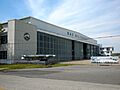
- Hangar No. 1 - United States Naval Air Station Wildwood: At the Cape May Airport in Lower Township, this hangar was part of a naval air station. It was used to train pilots during World War II. Today, it's a museum where you can learn about aviation history.
- TBM-3E "Avenger" Torpedo Bomber Warplane: Also at the Cape May Airport, this specific airplane is a historic artifact. It's a type of plane that was used by the U.S. Navy during World War II, known for its role in naval battles.
Historic Homes and Buildings
Many old houses and other buildings in Cape May County are recognized for their unique architecture or the important people who lived in them.
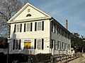
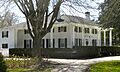
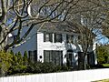
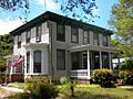
- J. Thompson Baker House: Built in 1909 in Wildwood, this house is a great example of early 20th-century architecture in the area.
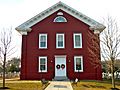
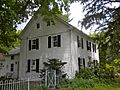
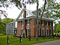
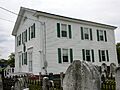
- Thomas Beesley Jr. House: Located in Middle Township, this house is a piece of local history.
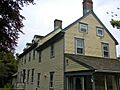
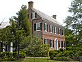
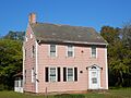
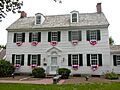
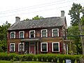
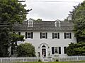
- Thomas Beesley Sr. House: Built in 1816 in Upper Township, this is one of the older homes on the list, showing how people lived long ago.
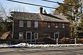
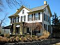
- Owen Coachman House: This house in Lower Township was built in 1846. It represents the style of homes from the mid-1800s.
- John Holmes House: Found in Cape May Court House, this house, built in 1799, is now the Museum of Cape May County. It's a fantastic place to learn about the county's past.
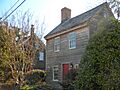
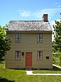
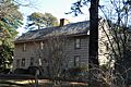
- Jonathan Pyne House: This house in Lower Township dates back to 1694, making it one of the oldest buildings on the list! It offers a glimpse into the very early days of the area.
- Whilldin–Miller House: Located in West Cape May, this house from 1800 is another example of early American homes in the region.
Unique and Modern Historic Places
Not all historic places are super old! Some are important because of their unique style or what they represent from more recent times.
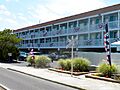
- Caribbean Motel: Built in 1958 in Wildwood Crest, this motel is famous for its "Doo Wop" architecture. This style uses bright colors, bold shapes, and neon lights, typical of the 1950s and 60s.
- Chateau Bleu Motel: Another "Doo Wop" style motel, built in 1962 in North Wildwood. These motels show a fun and unique part of New Jersey's beach resort history.
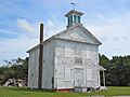
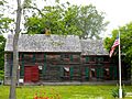
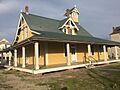
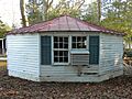
- Octagonal Poultry House: In Cold Spring, this unusual eight-sided building was used for raising chickens. It's a cool example of unique farm architecture.
Historic Districts and Other Sites
Sometimes, an entire area or a group of buildings is important enough to be listed.
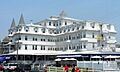
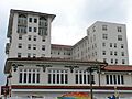
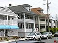
- Cape May Historic District: This large district in Cape May includes about 600 buildings! It's famous for its beautiful Victorian-era homes and hotels, making Cape May a very special historic town.
- Dennisville Historic District: Located in Dennis Township, this district preserves a collection of historic buildings that show what a small rural community looked like in the past.
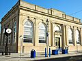
- Ocean City Residential Historic District: In Ocean City, this district features many historic homes, showing the development of this popular shore town.
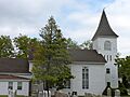
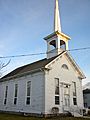
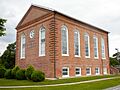
- Cold Spring Presbyterian Church: Built in 1823 in Lower Township, this church is a significant religious landmark in the area.
- Woodbine Brotherhood Synagogue: Located in Woodbine, this synagogue, built in 1900, is important for its role in the history of Jewish communities in South Jersey.
These are just some of the many amazing historic places in Cape May County. Each one has a story to tell about the people, events, and styles that shaped this part of New Jersey. Visiting them is like taking a step back in time!
Images for kids
-
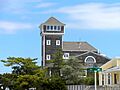
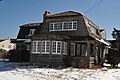
Avalon Life Saving Station
-
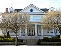
J. Thompson Baker House
-
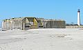
Battery 223
-
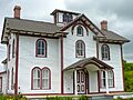
Thomas Beesley Jr. House
-
Thomas Beesley Sr. House
-
Brandywine Shoal Light Station
-
Calvary Baptist Church
-
Colonial Hotel in Cape May Historic District
-
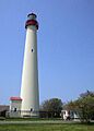
Cape May Lighthouse
-
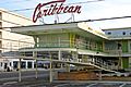
Caribbean Motel
-
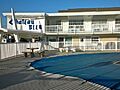
Chateau Bleu Motel
-
Owen Coachman House
-
Cold Spring Grange Hall
-
Cold Spring Presbyterian Church
-
John Corson, Jr. House Site
-
Dennisville Historic District
-
Joseph Falkinburg House
-
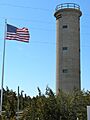
Fire Control Tower No. 23
-
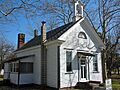
Fishing Creek Schoolhouse
-
The Flanders Hotel
-
Judge Nathaniel Foster House
-
John Wesley Gandy House
-
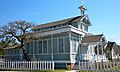
Goshen School
-
Hangar No. 1-United States Naval Air Station Wildwood
-
Hereford Lighthouse
-
George Hildreth House
-
John Holmes House
-
Thomas Leaming House
-
Henry Ludlam House
-
Thomas Ludlam Jr. House
-
Marine National Bank
-
Marshallville Historic District
-
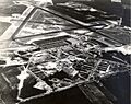
Naval Air Station Wildwood Historic District
-
New Asbury Methodist Episcopal Meeting House
-
Ocean City 34th Street Station
-
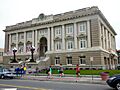
Ocean City City Hall
-
Ocean City Life-Saving Station
-
Ocean City Residential Historic District
-
Ocean City Tenth Street Station
-
Octagonal Poultry House
-
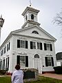
Old Cape May County Courthouse Building
-
Jonathan Pyne House
-
Reeves–Iszard–Godfey House
-
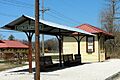
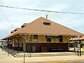
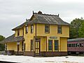
Rio Grande Station
-
Rufwud Cottage
-
Saint Peter's-By-The-Sea Episcopal Church
-
South Tuckahoe Historic District
-

TBM-3E "Avenger" Torpedo Bomber Warplane
-
William S. Townsend House
-
Tuckahoe Station
-
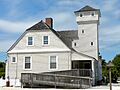
U.S. Life-Saving Station No. 35
-
Whilldin–Miller House
-
Woodbine Brotherhood Synagogue


