
List of islands of Greece facts for kids

Greece is famous for its many islands! There are thousands of them, but only about 166 to 227 are actually lived on. These islands are super important to Greece's history and culture.
The biggest Greek island is Crete. It's located at the southern edge of the Aegean Sea. The second largest is Euboea, which is so close to the mainland that it's only separated by a narrow 60-meter wide channel!
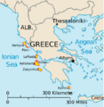
Greek islands are usually grouped into different areas. These include the Argo-Saronic Islands near Athens, the Cyclades in the middle of the Aegean Sea, and the Dodecanese islands in the southeast. There are also the North Aegean islands, the Sporades, and the Ionian Islands on the west side of the mainland. Crete and Euboea are usually considered separate from these groups.
We won't talk about the Peloponnese here. Even though it became an island after the Corinth Canal was built in 1893, it's usually not thought of as a natural island.
Contents
Biggest Greek Islands by Size


Here are the top 10 largest Greek islands based on their size:
| Rank | Island | Greek name | Area (km2) |
Cluster |
|---|---|---|---|---|
| 1 | Crete | Κρήτη | 8,336 | Cretan |
| 2 | Evia | Εύβοια | 3,670 | Euboean |
| 3 | Lesbos | Λέσβος | 1,633 | North Aegean Islands |
| 4 | Rhodes | Ρόδος | 1,401 | Dodecanese |
| 5 | Chíos | Χίος | 842.3 | North Aegean Islands |
| 6 | Kefalonia | Κεφαλονιά | 781 | Ionian Islands |
| 7 | Corfu | Κέρκυρα | 592.9 | Ionian Islands |
| 8 | Lemnos | Λήμνος | 477.6 | North Aegean Islands |
| 9 | Samos | Σάμος | 477.4 | North Aegean Islands |
| 10 | Naxos | Νάξος | 429.8 | Cyclades |
Most Populated Greek Islands
Here are the top 10 Greek islands with the most people living on them:
| Island | Population |
|---|---|
| Crete | 636,504 |
| Evia | 191,206 |
| Rhodes | 125,113 |
| Corfu | 102,071 |
| Lesbos | 83,755 |
| Chios | 50,361 |
| Zakynthos | 41,180 |
| Kos | 37,089 |
| Salamis | 37,220 |
| Kefalonia | 36,064 |
Islands of the Aegean Sea
The Aegean Sea is home to many Greek islands. Let's explore some of the main groups!
Argo-Saronic Islands
.jpg)
These islands are found in the Saronic Gulf, very close to Athens. The biggest one is Salamis. Here are some of the main islands in this group:
- Aegina
- Agistri
- Dokos
- Hydra
- Poros
- Salamis
- Spetses
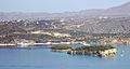
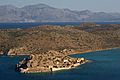
Cretan Islands
Crete is a large island, and it has many smaller islands, islets, and rocks around it. Some are in the Aegean Sea, and others are in the Libyan Sea to the south.
Cretan Islands in the Aegean Sea


01.jpg)
These islands are located around Crete in the Aegean Sea:
- Agioi Theodoroi
- Dia (also known as Zeus)
- Dionysades (a group of islands)
- Gramvoussa
- Kalydon (Spinalonga)
- Leon (an islet)
- Pondikonisi (meaning "Mouse Island" because of its shape)
- Souda (an islet)
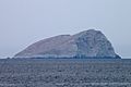
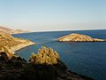
Cretan Islands in the Libyan Sea

The islands on the south coast of Crete are in the Libyan Sea.
- Chrysi (also called Gaidouronisi)
- Elafonisi
- Gavdopoula
- Gavdos (the southernmost point of Greece!)
- Koufonisi (Lefki)
- Paximadia (two small islands)
- Trafos (an islet)
Cyclades Islands


The Cyclades group has about 220 islands and islets. The name "Cyclades" means "circular," as they form a circle around the sacred island of Delos. Here are some of the main ones:
- Amorgos
- Anafi
- Andros
- Antiparos
- Delos (a very important ancient site)
- Folegandros
- Ios
- Kea
- Kimolos
- Kythnos
- Milos
- Mykonos (famous for its windmills)
- Naxos
- Paros
- Santorini (Thera, known for its stunning views)
- Serifos
- Sifnos
- Syros
- Tinos
Dodecanese Islands


The Dodecanese group has 164 islands, with 26 of them inhabited. "Dodecanese" means "twelve islands," referring to the 12 main ones.
- Astypalaia
- Kalymnos
- Karpathos
- Kasos
- Kastellorizo (Megisti, the easternmost point of Greece!)
- Kos
- Leros
- Nisyros
- Patmos
- Rhodes
- Symi
- Tilos
Euboea and Surrounding Islands
Euboea is the second-largest Greek island. It's very close to the mainland. Here are some islands near it:
- Atalanti (uninhabited)
- Euboea
- Lichades (a group of islands)
- Petalioi (a group of 10 small islands)
North Aegean Islands
These islands are located off the west coast of Turkey.
There are also two North Aegean islands in the Thracian Sea:
- Samothrace
- Thassos
Sporades Islands

The Sporades group has about 30 islands. The largest is Skyros. The four main islands are:
- Alonissos
- Skiathos
- Skopelos
- Skyros
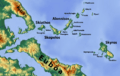
Ionian Sea Islands


These islands are located to the west of mainland Greece in the Ionian Sea. The seven largest and most popular ones are:
- Cephalonia
- Corfu
- Ithaca
- Kythira
- Lefkada
- Paxi
- Zakynthos
Other islands in this group include:
- Antikythera
- Antipaxos
- Echinades (a group of islands)
- Elafonissos
- Meganisi
- Othonoi (the westernmost point of Greece!)
- Skorpios (a famous private island)
Islands Not in the Sea
Not all islands are in the sea! Some are found in lakes or lagoons.
Lake and River Islands

- Agios Achilleios (in Small Prespa Lake)
- Ioannina Island (in Lake Pamvotida)
Islands in an Island
Yes, there's even an island inside a lake on another island!
- Marathi Island (in Marathi Lake, which is on Mykonos)
Lagoon Islands
Lagoons are shallow bodies of water separated from the sea by narrow strips of land.
- Aitoliko (in Aitoliko Lagoon)
- Islands in the Missolonghi Lagoon, such as:
- Dolmas
- Kleisova
- Tourlida
Images for kids
-
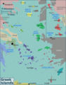
Regions for Greek islands
-
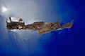
NASA image of Crete
-
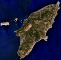
NASA image of Rhodes
-
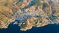
Aerial view of the port city of Hydra on Hydra Island
-
The islet of Leon, on the left, next to the larger islet of Souda, within Souda bay
-
Spinalonga (Kalydon)
-
The islet of Pontikonisi (mouse island) which has the shape of a mouse.
-
The islet of Trafos in the Libyan Sea
-
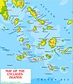
Cyclades islands
-
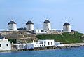
Iconic windmills of Mykonos
-
Dodcanese Islands
-
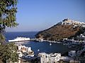
Harbor of the island of Astypalaia
-
Northern Sporades
-
Main Ionian Islands
-
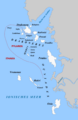
Echinades islands
-
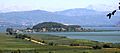
Ioannina island in Lake Pamvotida
See also
 In Spanish: Anexo:Islas de Grecia para niños
- Geography of Greece
- Ionian Islands
- List of Aegean Islands
