
Karpathos facts for kids
Quick facts for kids
Karpathos
Κάρπαθος
|
|
|---|---|

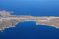
View of the port of Pigadia
|
|

Karpathos
Location in Greece
|
|
| Country | Greece |
| Administrative region | South Aegean |
| Regional unit | Karpathos-Kasos |
| Area | |
| • Municipality | 324.8 km2 (125.4 sq mi) |
| • Municipal unit | 219.9 km2 (84.9 sq mi) |
| Highest elevation | 1,215 m (3,986 ft) |
| Lowest elevation | 0 m (0 ft) |
| Population
(2021)
|
|
| • Municipality | 6,567 |
| • Municipality density | 20.219/km2 (52.366/sq mi) |
| • Municipal unit | 6,037 |
| • Municipal unit density | 27.453/km2 (71.104/sq mi) |
| Community | |
| • Population | 3,047 (2021) |
| Time zone | UTC+2 (EET) |
| • Summer (DST) | UTC+3 (EEST) |
| Postal code |
857 00
|
| Area code(s) | +030 22450 |
| Vehicle registration | ΚΧ, ΡΟ, ΡΚ |
Karpathos (Greek: Κάρπαθος) is a beautiful Greek island in the southeastern Aegean Sea. It is the second largest island in the Dodecanese group. Karpathos and the smaller Saria Island nearby form the local government area called the Municipality of Karpathos.
Because Karpathos is a bit far away from other places, it has kept many of its special traditions. These include unique clothing, customs, and even a dialect (a way of speaking) that sounds a bit like the Greek spoken in Crete and Cyprus. In the past, the island was also known as Carpathus in Latin and Scarpanto in Italian.
Contents
- What's in a Name? The History of Karpathos's Names
- Karpathos Today: How the Municipality Works
- Ancient Stories: Karpathos in Mythology
- A Journey Through Time: The History of Karpathos
- Exploring Karpathos: Early Discoveries
- The Geography of Karpathos: Mountains, Villages, and Seas
- Getting Around Karpathos: Transportation
- Who Lives on Karpathos? The Population
- Beautiful Beaches of Karpathos
- Images for kids
- See also
What's in a Name? The History of Karpathos's Names
The famous ancient Greek writer Homer called the island Krapathos in his epic poem, the Iliad. This name is very similar to Karpathos. The island was also known by other names, like Tetrapolis, which means "four cities," and Anemoessa, which means "windy."
Karpathos Today: How the Municipality Works
The current local government of Karpathos was created in 2011. It brought together two smaller areas, Karpathos and Olympos, into one larger municipality.
- Olympos is a very traditional village in the north of the island.
- The total area of the municipality is about 324.8 square kilometers.
Ancient Stories: Karpathos in Mythology
In ancient Greek myths, Karpathos is a very special place. It is said to be the home of the powerful Titan Iapetus. It is also believed to be the birthplace of Proteus, a sea god who could change his shape.
A Journey Through Time: The History of Karpathos
Karpathos has a long and interesting history, often linked with the nearby island of Rhodes. The island's name, Krapathos, is mentioned in Homer's famous story, the Iliad. Another ancient writer, Apollonius of Rhodes, wrote that the Argonauts (a group of heroes in Greek mythology) stopped at Karpathos during their travels.
Early History and Roman Rule
Ancient writers like Diodorus believed that Karpathos was settled by the Dorians, an ancient Greek group. The people of Karpathos sided with Sparta during the Peloponnesian War around 431 BCE. However, they lost their independence to Rhodes in 400 BCE. Later, in 42 BCE, the island became part of the powerful Roman Empire. After the Roman Empire split in 395 CE, Karpathos became part of the Byzantine Empire.
Medieval Times and Venetian Control
In 1304, Karpathos was given to some Genoese corsairs (pirates) named Andrea and Lodovico Moresco. But in 1306, it was taken over by Andrea Cornaro, a member of the powerful Venetian family, the Cornaro. The Cornaro family ruled Karpathos until 1538. After that, the island became part of the Ottoman Empire.
Ottoman Rule and Independence Struggles
During the Greek War of Independence (1821-1822), the people of Karpathos bravely rebelled against Ottoman rule. However, the island eventually fell back under Ottoman control. In 1835, the Ottoman Sultan Mahmud II gave Karpathos a special tax system. This meant the island paid a single yearly tax instead of taxes based on each household.
Italian Occupation and Joining Greece
Ottoman rule ended on May 12, 1912, when Italian forces occupied Karpathos during the Italo-Turkish War. With the Treaty of Lausanne (1923), Karpathos became an Italian possession along with other Dodecanese islands. The Italians occupied the island until September 1943. After Italy surrendered in World War II, German forces took over Karpathos. They left the island on October 4, 1944.
Finally, Karpathos was given to Greece with the Paris Peace Treaties, 1947. The island officially became part of Greece on March 7, 1948, along with the other Dodecanese islands.
Modern Karpathos: Emigration and Return
In the late 1940s and 1950s, many people from Karpathos moved to cities on the eastern coast of the United States. This was due to economic problems after World War II. Today, many Greek-Americans from Karpathos have returned to the island and invested in its future. People living in the northern mountains of the island tend to keep more traditional ways of life.
Exploring Karpathos: Early Discoveries
In the late 1800s, British explorers Theodore and Mabel Bent visited Karpathos in 1885. They spent a lot of time digging at a place called Vroukounta in the far north of the island. Some of the ancient items they found are now displayed in the British Museum in London.
The Geography of Karpathos: Mountains, Villages, and Seas
Karpathos is located about 47 kilometers southwest of Rhodes. The sea around it is even called the Carpathian Sea. The Sea of Crete, another part of the Mediterranean, has its eastern edge defined by Karpathos.
Island Features
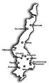
The highest point on Karpathos is a peak called Kali Limni, which is 1,215 meters tall. The island has 11 main villages.
- Pigadia is the capital and main port of Karpathos. It is located in the southeast.
- Around Pigadia, you'll find villages like Menetes, Arkasa, Finiki, Pyles, Othos, Volada, and Aperi.
- Mesochori and Spoa are in central Karpathos.
- Olympos and Diafani (the island's second port) are in the north.
Saria Island
The small island of Saria was once connected to Karpathos. A powerful earthquake separated them long ago. Saria is home to many important ancient ruins.
Karpathos Climate: Warm and Sunny
Karpathos has a warm, semi-dry climate. This means it has hot summers and mild winters. It's known for having one of the mildest winters in Europe! The lowest temperature ever recorded there was only 2.2°C.
Getting Around Karpathos: Transportation
Karpathos Island National Airport is located on the south side of the island. Karpathos is connected to other islands and the mainland of Greece by ferries and airplanes.
- Ferries travel to and from Piraeus (the port of Athens), stopping at Crete and Rhodes.
- Flights connect Karpathos daily with Rhodes, Kasos, Crete, and Athens.
- During the busy summer months (April to October), many charter flights from European cities also come to Karpathos.
Local Travel
On the island itself, cars are the most common way to get around. The port, airport, main villages, and popular spots are connected by good paved roads. In the summer, small private boats leave from Pigadia daily. They go to places like Olympos (via Diafani) and some beaches that are hard to reach by road. Taxis and local buses are also available all year.
Who Lives on Karpathos? The Population
In 2021, the population of Karpathos was 6,567 people. This number more than doubles in the summer! Many Karpathians who live abroad come back to the island for their vacations with their families. When you add in all the tourists, there can be up to 20,000 people on the island during the summer months.
The island is especially busy on August 15th. This is because of the Panagia's festival, which is the most important festival on Karpathos. People travel from all over the world to attend this festival and see the many old traditions that are still kept alive on the island.
Population Changes Over Time
Here's how the population of some communities on Karpathos has changed over the years:
| Community | 1947 | 1951 | 1961 | 1971 | 1981 | 1991 | 2001 | 2011 | 2021 |
|---|---|---|---|---|---|---|---|---|---|
| Karpathos (Pigadia) | - | - | - | - | - | - | 2,180 | 2,788 | 3,047 |
| Menetes | 1,651 | 1,499 | 1,413 | 1,233 | 1,179 | 954 | 760 | 662 | 638 |
| Arkasa | - | - | - | - | 390 | 394 | 507 | 564 | 540 |
| Olympos | - | - | - | - | - | - | 684 | 556 | 530 |
| Mesochori | - | - | - | - | 357 | 344 | 446 | 371 | 451 |
| Aperi | - | - | - | - | 457 | 402 | 470 | 355 | 428 |
| Othos | - | - | - | - | 282 | 229 | 385 | 281 | 264 |
| Volada | - | - | - | - | - | - | 418 | 264 | 241 |
| Spoa | 339 | 340 | 380 | 293 | 251 | 254 | 301 | 169 | 224 |
| Pyles | - | - | - | - | - | - | 414 | 216 | 204 |
Beautiful Beaches of Karpathos
Karpathos island has many different types of beaches, perfect for every taste! They can be grouped into four main areas:
- East Coast Beaches: These beaches are usually smaller and have pebbles or gravel. They are often protected from the wind, making them calm.
- Examples: Amoopi, Karpathos Beach (Vrontis), Achata, Kyra Panagia, Apella, Agios Nikolaos (Spoa).
- South Coast Beaches: Near the airport, these beaches are known for their soft, white sand.
- Examples: Mihaliou o Kipos (also called "Shell beach"), Damatria, Diakoftis, Devils Bay, Agrilaopotamos, Pounta beach.
- West Coast Beaches: These sandy beaches are more exposed to the strong summer winds called the Meltemi. They are best visited when the wind is not too strong.
- Examples: Lefkos beach, Mesohori, Finiki, Arkasa Leucadius.
- North Coast Beaches: Many of these beaches can only be reached by boat, or sometimes by a jeep on rough roads.
- Examples: Diafani, Alimounta (on Saria island), Palatia (on Saria island), Kalamia, Vananda, Apokapos (or Papa-Mina), Opsi, Kantri, Forokli, Kapi, Nati, Philios (or Agios Minas), Agnontia.
Images for kids
-
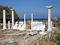
Remains of the early Christian basilica of St Fotini, Pigadia
-
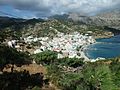
Diafáni village.
-
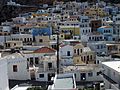
Menetes village.
-
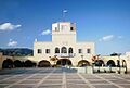
The Administration Building in Papagos Square, Pigadia, also houses the Karpathos Archaeological Museum.
-
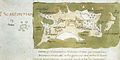
Map of Karpathos, by Buondelmonti Cristoforo, 1420.
-
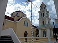
Main church of Diafani
-
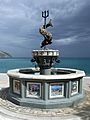
Modern fountain of Neptune (Poseidon) in Diafáni.
-
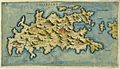
Map of Karpathos (Scarpanto), by Giacomo Franco, 1597
-
The airport
-
The twelve villages of Karpathos


.jpg)


See also
 In Spanish: Kárpatos para niños
