Livingston County, Michigan facts for kids
Quick facts for kids
Livingston County
|
|
|---|---|

|
|

Location within the U.S. state of Michigan
|
|
 Michigan's location within the U.S. |
|
| Country | |
| State | |
| Founded | 1833 (authorized) 1836 (organized) |
| Named for | Edward Livingston |
| Seat | Howell |
| Largest city | Howell |
| Area | |
| • Total | 585 sq mi (1,520 km2) |
| • Land | 565 sq mi (1,460 km2) |
| • Water | 20 sq mi (50 km2) 3.4%% |
| Population
(2020)
|
|
| • Total | 193,866 |
| • Density | 320/sq mi (120/km2) |
| Time zone | UTC−5 (Eastern) |
| • Summer (DST) | UTC−4 (EDT) |
| Congressional district | 7th |
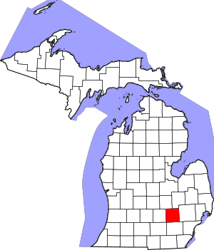
Livingston County is a county located in the state of Michigan, USA. In 2020, about 193,866 people lived here. It is part of the larger Detroit area.
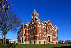
The main city and county seat is Howell. The county was first planned in 1833. It officially became a county in 1836. Livingston County is one of Michigan's "Cabinet counties." These counties were named after members of President Andrew Jackson's team. This county is named after Edward Livingston, who was a US Secretary of State.
Livingston County is in Southeast Michigan. This means it's easy for people to get to big cities like Detroit, Lansing, Ann Arbor, and Flint. Many people who live in Livingston County travel to these cities for work. They use major highways like I-96, US 23, and M-59.
Even though many people live here and travel to other cities, Livingston County is growing. It has more jobs in services and industries. Some big companies here include Tribar, PepsiCo, Citizens Insurance, and ThaiSummit. You can also find the Brighton Recreation Area in the county.
Contents
Geography of Livingston County
The US Census Bureau says the county covers about 585 square miles. Most of this (565 square miles) is land. The rest (20 square miles) is water, like lakes and rivers.
Counties Nearby
- Shiawassee County – to the northwest
- Genesee County – to the northeast
- Oakland County – to the east
- Washtenaw County – to the south
- Jackson County – to the southwest
- Ingham County – to the west
People of Livingston County
| Historical population | |||
|---|---|---|---|
| Census | Pop. | %± | |
| 1840 | 7,430 | — | |
| 1850 | 13,485 | 81.5% | |
| 1860 | 16,851 | 25.0% | |
| 1870 | 19,336 | 14.7% | |
| 1880 | 22,251 | 15.1% | |
| 1890 | 20,858 | −6.3% | |
| 1900 | 19,664 | −5.7% | |
| 1910 | 17,736 | −9.8% | |
| 1920 | 17,522 | −1.2% | |
| 1930 | 19,274 | 10.0% | |
| 1940 | 20,863 | 8.2% | |
| 1950 | 26,725 | 28.1% | |
| 1960 | 38,233 | 43.1% | |
| 1970 | 58,967 | 54.2% | |
| 1980 | 100,289 | 70.1% | |
| 1990 | 115,645 | 15.3% | |
| 2000 | 156,951 | 35.7% | |
| 2010 | 180,967 | 15.3% | |
| 2020 | 193,866 | 7.1% | |
| 2023 (est.) | 196,757 | 8.7% | |
| US Decennial Census 1790–1960 1900–1990 1990–2000 2010–2019 |
|||
In 2010, there were 180,967 people living in Livingston County. Most people (96.7%) were White. About 0.8% were Asian, and 0.4% were Black or African American. About 1.9% of people were Hispanic or Latino. Most people (95.9%) spoke only English at home.
The average age of people in the county was 36 years old. About 28.8% of the population was under 18. About 8.3% of people were 65 or older.
Livingston County is known for having a high income. In 2010, it had one of the highest average family incomes in Michigan.
Most of the people in the county live in the southeastern towns. These include Brighton Township, Genoa Township, and Green Oak Township. The cities of Brighton and Howell are considered a growing urban area.
Media in Livingston County
Livingston County has a few local news sources.
- The Livingston County Daily Press & Argus is a newspaper that comes out daily, except Saturdays. It started in 2000.
- The Community Journal is a weekly newspaper. It started in 2010 and covers Pinckney, Fowlerville, and Howell.
- WHMI-FM is a local radio station. It plays classic hits and shares local news every hour.
- The Marketeer is a free magazine. It is sent to over 42,000 homes each month. It has ads from local businesses and stories about community events. It has been published since 1974.
Transportation in Livingston County
Major Highways
 I-96 runs through the middle of the county. It passes through Fowlerville, Howell, and Brighton.
 BL I-96 is a business loop that goes through Howell.
 US 23 runs north to south through the eastern part of the county. It passes through Hartland, Brighton, and Whitmore Lake.
 M-36 runs through the lower part of the county. It passes through Pinckney and Hamburg.
 M-59 runs from the east side of the county to I-96.
- M-106 enters the county from the west.
 D-19 runs south from Pinckney.
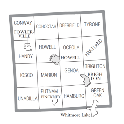
Communities in Livingston County
Cities
Villages
Charter Townships
Civil Townships
- Cohoctah Township
- Conway Township
- Deerfield Township
- Hamburg Township
- Handy Township
- Hartland Township
- Howell Township
- Iosco Township
- Marion Township
- Oceola Township
- Putnam Township
- Tyrone Township
- Unadilla Township
Census-Designated Places
- Hartland
- Whitmore Lake (partly in this county)
Other Small Communities
- Anderson
- Bullis Crossing
- Chalkerville
- Chilson
- Cohoctah
- Cohoctah Center
- Deer Creek
- Deerfield Center
- Fleming
- Green Oak
- Gregory
- Hallers Corners
- Hamburg
- Hell
- Island Lake
- Kaiserville
- Lakeland
- Nicholson (partly in this county)
- Oak Grove
- Parkers Corners
- Parshallville
- Plainfield
- Pettysville
- Rushton
- Tyrone Center
- Unadilla
- Williamsville
See also
 In Spanish: Condado de Livingston (Míchigan) para niños


