
Long Lake, New York facts for kids
Quick facts for kids
Long Lake, New York
|
|
|---|---|
.jpg)
The hamlet of Long Lake approaching on N.Y. Route 30 from the bridge.
|
|

Location in Hamilton County and the state of New York.
|
|

Long Lake, New York
Location in New York Adirondack Park
|
|
| Country | United States |
| State | New York |
| County | Hamilton |
| Government | |
| • Type | Town Board |
| Area | |
| • Total | 449.84 sq mi (1,165.07 km2) |
| • Land | 407.03 sq mi (1,054.21 km2) |
| • Water | 42.80 sq mi (110.86 km2) 9.51% |
| Elevation | 1,906 ft (581 m) |
| Population
(2020)
|
|
| • Total | 791 |
| • Density | 1.7584/sq mi (0.6789/km2) |
| Time zone | UTC-5 (Eastern (EST)) |
| • Summer (DST) | UTC-4 (EDT) |
| ZIP code |
12847
|
| Area code | 518 |
| FIPS code | 36-041-43412 |
| GNIS feature ID | 979168 |
Long Lake is a small town in Hamilton County, New York, United States. In 2020, about 791 people lived there.
The town gets its name from the Long Lake itself, which is about 14 miles (23 km) long. A smaller area called Long Lake (CDP) is inside the town. Most of the town's people live in this smaller area. The entire town is located within the beautiful Adirondack Park. It is the northernmost town in Hamilton County.
Long Lake is a popular spot for summer vacations. People enjoy fishing, hiking, boating, and swimming there. In winter, snowmobiling is a big activity. The town is also home to the historic Adirondack Hotel. Plus, it hosts the Sabattis Scout Reservation, a camp for the Boy Scouts of America.
Contents
History of Long Lake Town
The town of Long Lake was first settled around 1833 by Joel Plumley, who came from Vermont.
How Long Lake Town Was Formed
The town of Long Lake was officially created in 1837. It was made from parts of other towns like Arietta, Morehouse, Lake Pleasant, and Wells. In 1861, the town grew even larger with more land from Arietta, Lake Pleasant, and Morehouse.
Early Travel and Development
Long Lake is part of a huge area of land, about 1.1 million acres (4,500 km²), that was bought from the Mohawk nation in 1771. The lake itself is a wider part of the Raquette River. This river was an important travel route in the 1800s. People used special boats called "guideboats" to travel through the lakes and rivers, connecting places like the Fulton Chain Lakes to the Saint Lawrence River.
For a long time, Long Lake was quite isolated. You could only reach it easily by water. This changed in 1892 when the Mohawk and Malone Railway was built. This railway went through an area then known as Long Lake West. Long Lake and Long Lake West were connected by a stagecoach route. The railway later became part of the New York Central Railroad, but passenger train service stopped in 1965. Long Lake West was later renamed Sabattis, honoring Peter Sabattis and his son Mitchell Sabattis, who were Native American guides and early settlers.
In 1908, a fire destroyed most of the town of Long Lake West.
The Roosevelt-Marcy Trail Connection
Long Lake is the starting point of the Roosevelt-Marcy Trail. This trail is famous because of an event involving Theodore Roosevelt. On September 14, 1901, Roosevelt was climbing Mount Marcy. He received news that President William McKinley was very ill after being shot.
Roosevelt quickly came down from his camp. He rushed about 10 miles (16 km) to the nearest town with a telephone, which was near Newcomb. From there, he took a famous midnight stagecoach ride about 26 miles (42 km) to the closest train station in North Creek. It was there that he learned President McKinley had died. Roosevelt then became president in Buffalo.
Geography of Long Lake
Long Lake is located in the northern part of Hamilton County. Its elevation is about 1,906 feet (581 meters) above sea level. To the west, it borders Herkimer County. To the north, it borders St. Lawrence and Franklin counties. To the east, it borders Essex County.
Size and Location
The town of Long Lake covers a total area of about 449.8 square miles (1,165.1 km²). Most of this is land (407.0 square miles or 1,054.2 km²), and about 42.8 square miles (110.9 km²) is water.
Long Lake is entirely within the Adirondack Park. It is the second-largest town in New York State by land area. The town stretches about 25 miles (40 km) from east to west and up to 12 miles (19 km) from north to south. It covers the northern part of Hamilton County.
Roads and Waterways
New York State Route 30 is a main north-south highway that crosses New York State Route 28N in Long Lake village. Both routes run together for a part of the town. New York State Route 28 is another highway in the southwestern part of the town.
The main body of water, Long Lake, is about 14 miles (23 km) long and up to 1 mile (1.6 km) wide. It runs from southwest to northeast and is part of the Raquette River system. The Raquette River flows into Long Lake at one end and out the other, eventually reaching the St. Lawrence River.
People of Long Lake
In 2000, there were 852 people living in Long Lake. The population density was about 2.1 people per square mile (0.8 people per km²). There were 387 households in the town.
Population Changes Over Time
The population of Long Lake has changed over the years:
- 1840: 59
- 1850: 111
- 1860: 223
- 1870: 280
- 1880: 324
- 1890: 580
- 1900: 1023
- 1910: 1149
- 1920: 1116
- 1930: 1038
- 1940: 943
- 1950: 896
- 1960: 896
- 1970: 900
- 1980: 935
- 1990: 930
- 2000: 852
- 2010: 711
- 2020: 791
Age and Income
In 2000, the median age in Long Lake was 47 years old. About 18.4% of the population was under 18. The median income for a household in the town was $29,583. For families, the median income was $44,583.
Communities and Places in Long Lake
Inhabited Areas
- Deerland – This small community is at the southeastern end of Long Lake.
- Deerland Camp – A spot located on Little Forked Lake.
- Golden Beach – Found on the eastern side of Raquette Lake.
- Hasbroucks – A community on the northern shore of Raquette Lake.
- Long Lake – This is the main community, also called the Hamlet of Long Lake. It's near the center of the lake.
- Nehesane – An uninhabited area in the northwestern part of the town, near Lake Lila.
- Partlow – A location southwest of Lake Lila.
- Raquette Lake – A community on the western shore of Raquette Lake.
- Robinwood – A location in the northwestern part of the town.
- Sabattis – An abandoned community on the northern town line. It was once called "Long Lake West." Part of it is now the "Sabattis Scout Reservation" for Boy Scouts.
- Sagamore – A location near the southern town line.
- Whitney Headquarters – A location in the northern part of the town, on Little Tupper Lake.
- Woods – A location northeast of Raquette Lake.
Natural Features
- Beaver River – A river that flows out of the western side of the town.
- Big Island – A large island in Raquette Lake.
- Bluff Point – A piece of land sticking out into Raquette Lake.
- Brandreth Lake – A lake north of Raquette Lake.
- Catlin Lake – A lake at the eastern town line.
- Chub Lake – A lake west of Raquette Lake.
- Cranberry Pond – A pond northwest of the Raquette Lake community.
- Forked Lake – A lake northeast of Woods, near the southern town line.
- High Pond – A small pond on the northern town line.
- Indian Point – A piece of land sticking out into Raquette Lake.
- Lake Eaton – A lake west of Long Lake community.
- Lake Lila – A lake in the northwest of Long Lake, where the Beaver River begins.
- Little Forked Lake – A small lake north of Forked Lake.
- Little Tupper Lake – A large lake in the northern part of the town.
- Lows Lake – A lake at the northern town line.
- Long Lake – The large lake that gives the town its name.
- Long Lake Town Beach – The town's public beach. It's also home to Helms Aero Service, which offers seaplane rides.
- Long Point – A piece of land sticking out into Raquette Lake.
- Lower Sister Lake – A lake northwest of Raquette Lake.
- Mays Pond – A pond west of Chub Lake.
- Mohegan Lake – A lake south of Raquette Lake.
- Nehasane Lake – A lake near the western town line on the Beaver River.
- Negro Lake – A lake southwest of Partlow Mountain.
- Outlet Bay – The northwestern part of Raquette Lake.
- Pelcher Pond – A lake west of the Raquette Lake community.
- Queer Lake – A lake east of the Raquette Lake community.
- Raquette Lake – A large lake in the western part of the town. It is the fourth largest lake in the Adirondack region.
- Round Lake – A lake in the northern part of Long Lake.
- Russian Lake – A lake west of the Raquette Lake community.
- Sagamore Lake – A lake south of Raquette Lake.
- Shallow Lake – A lake west of the Raquette Lake community.
- South Pond – A lake south of Deerland.
- Upper Sister Lake – A lake northwest of Raquette Lake.
Images for kids
-
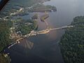
The hamlet of Long Lake from the air
-
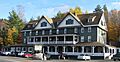
The Adirondack Hotel
-
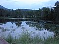
The Mill Pond
-

Long Lake, NY logo


See also
 In Spanish: Long Lake (Nueva York) para niños
