Long Mountain (Powys) facts for kids
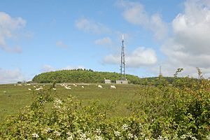
Long Mountain (which is called Welsh: Cefn Digoll in Welsh) is a hill that sits right on the border between Powys in Wales and Shropshire in England. It's located to the east of Welshpool. The very top of the mountain, called Beacon Ring, is 408 metres (1,339 feet) high and is in Wales. Long Mountain is known as a Marilyn, which is a special type of hill that rises at least 150 metres (about 500 feet) above the land around it. Long Mountain rises 305 metres (1,000 feet) from its base.
Contents
What Long Mountain is Made Of (Geology)
Long Mountain is made up of many layers of sedimentary rocks. These rocks were formed a very long time ago during the Silurian period. Imagine layers of mud, sand, and silt that settled down and hardened over millions of years.
The rocks are stacked in a specific order, with the youngest layers at the top. Here are some of the main rock layers found there:
- Raglan Mudstone Formation (made of siltstone and mudstone)
- Temeside Mudstone Formation (mudstone, siltstone, and sandstone)
- Tilestones Formation (sandstone)
- Cefn Einion Formation (mudstone, siltstone, and sandstone)
- Knucklas Castle Formation (mudstone, siltstone, and sandstone)
- Bailey Hill Formation (siltstone and sandstone)
- Irfon Formation (mudstone and siltstone)
- Gyfenni Wood Shale Formation (mudstone)
- Trewern Brook Mudstone Formation (mudstone)
- Tarannon Mudstone Formation (mudstone)
- Cefn Formation (mudstone and sandstone)
The top three rock types listed are part of the Old Red Sandstone group. You can only find these in the eastern part of the area. The very top of Long Mountain, near its southwestern end, is made of rocks from the Knucklas Castle Formation. Many faults (cracks in the Earth's crust) also cut through these rock layers.
Around the edges of Long Mountain, you can find deposits left behind by melting glaciers from the last ice age. These are called glaciofluvial deposits. There are also pockets of glacial till (rock and dirt left by glaciers) in some of the valleys.
Where Long Mountain Is (Geography)
Long Mountain stretches from Forden, Powys, in the southwest all the way to Vennington near Westbury in Shropshire in the northeast. Sometimes, people think the Breidden Hills to the north are part of Long Mountain. However, a valley separates them. This valley has a railway line and a main road (the A458) that connect Welshpool with Shrewsbury.
Long Mountain's Past (History)
It's thought that a Roman road once ran along Long Mountain. This road might have been part of a route from Uriconium (which is now Wroxeter) to Lavobrinta (Forden Gaer). At the southern end of the hill and along its western sides, you can still see parts of Offa's Dyke.
There is an old hillfort at Beacon Ring, which is at the southern end of Long Mountain. This fort was probably built during the Iron Age. It might have been used again in medieval times. Since 2008, the Clwyd-Powys Archaeological Trust has owned this site. They have been doing archaeological digs there in recent years. Beacon Ring is also known for a special tree plantation that spells out 'EIIR', which stands for Queen Elizabeth II.
In the year 630, Long Mountain was the site of the Battle of Cefn Digoll. This battle was fought between the kingdom of Northumbria and an alliance of Gwynedd (a Welsh kingdom) and Mercia (an English kingdom). Towards the eastern end of Long Mountain, you can find the remains of Caus Castle. This castle was built by the Normans on top of an even older Iron Age hillfort.
Fun Things to Do and Places to Go (Recreation and Access)
The Offa's Dyke Path is a famous walking trail that leaves Offa's Dyke at Buttington. It then heads up to the summit of Long Mountain before rejoining the Dyke as it goes south. Another trail, the Cross Britain Way, follows the Offa's Dyke Path between Buttington and the summit. After that, it heads east to Brockton on the southeast side of the hill.
Route 81 of the National Cycle Network also crosses Long Mountain. This route connects Welshpool and Shrewsbury. There are a few areas of land that are open for everyone to explore, like Walton Hill and Heldre Hill. There's also a good network of public paths that run between the many small roads in the area. Gunley Wood is a forest that is open to the public. It is owned and managed by Natural Resources Wales and is located at the very southern edge of Long Mountain.
 | Aaron Henry |
 | T. R. M. Howard |
 | Jesse Jackson |


