Lumberton, New Jersey facts for kids
Quick facts for kids
Lumberton, New Jersey
|
|
|---|---|
|
Township
|
|

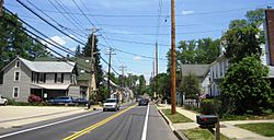
Center of Lumberton
|
|

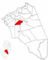
Lumberton Township highlighted in Burlington County. Inset map: Burlington County highlighted in the State of New Jersey.
|
|

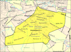
Census Bureau map of Lumberton, New Jersey
|
|
| Country | |
| State | |
| County | |
| Incorporated | March 14, 1860 |
| Government | |
| • Type | Township |
| • Body | Township Committee |
| Area | |
| • Total | 13.01 sq mi (33.71 km2) |
| • Land | 12.88 sq mi (33.37 km2) |
| • Water | 0.13 sq mi (0.34 km2) 1.01% |
| Area rank | 183rd of 565 in state 18th of 40 in county |
| Elevation | 10 ft (3 m) |
| Population
(2020)
|
|
| • Total | 12,803 |
| • Estimate
(2023)
|
12,886 |
| • Rank | 199th of 565 in state 12th of 40 in county |
| • Density | 993.9/sq mi (383.7/km2) |
| • Density rank | 386th of 565 in state 24th of 40 in county |
| Time zone | UTC−05:00 (Eastern (EST)) |
| • Summer (DST) | UTC−04:00 (Eastern (EDT)) |
| ZIP Code |
08048
|
| Area code(s) | 609 |
| FIPS code | 3400542060 |
| GNIS feature ID | 0882091 |
| Website | |
Lumberton is a small town, also called a township, located in Burlington County, New Jersey. It's part of a larger area that includes cities like Philadelphia and Camden. In 2020, about 12,803 people lived here.
Lumberton became an official township on March 14, 1860. It was formed from parts of nearby towns like Medford and Southampton. The town got its name because of its early history with the lumber industry. Many pine trees were cut down here to provide wood for the city of Philadelphia.
In 2007, Lumberton was known for having a lot of active eBay users. People in the town's ZIP code (08048) posted thousands of items for sale online!
Contents
History of Lumberton
The first people to live in the area now known as Lumberton were the Lenape Native Americans. Later, in the 1600s, European settlers started to arrive. They cleared forests and began farming, especially around a community called Fostertown.
Another important early settlement was Eayrestown, founded by Richard and Elizabeth Eayres. This place became a center for trade and had a sawmill, which was very important for processing wood. The village of Lumberton grew out of these two early communities.
Lumberton and the Underground Railroad
Some homes in Lumberton have a connection to the time of slavery. Early settlers had different ideas about slavery, with some supporting it and others working against it. Over time, many people in Lumberton became strong supporters of ending slavery across the country.
One special historical place is a house on Creek Road, built in 1824. This house was part of the Underground Railroad, a secret network that helped enslaved people escape to freedom. A book called Hippocrene Guide to the Underground Railroad mentions a hidden well in the backyard of this house. Enslaved people would hide in this fake well as they made their way to Canada, seeking freedom.
Lumberton During the Cold War
During the Cold War, Lumberton was part of a defense plan called Project Nike. If there had been a nuclear war, special missiles called Nike Ajax and Hercules would have been launched from bases in Lumberton and nearby areas. This was meant to protect the Delaware Valley from attacks.
Geography of Lumberton
Lumberton Township covers about 13.01 square miles (33.71 square kilometers). Most of this area is land, with a small part being water.
Lumberton shares its borders with several other towns in Burlington County. These include Eastampton, Hainesport, Medford, Mount Holly, Mount Laurel, and Southampton.
Some smaller communities and places within Lumberton Township are Brown, Eayrestown, Fostertown, and Newbolds Corner.
Lumberton's Climate
Lumberton experiences a climate with warm summers and mild winters. Here's a look at the average temperatures and rainfall:
| Climate data for Lumberton, New Jersey (South Jersey Regional Airport) 1991–2020 normals, extremes 1997–present | |||||||||||||
|---|---|---|---|---|---|---|---|---|---|---|---|---|---|
| Month | Jan | Feb | Mar | Apr | May | Jun | Jul | Aug | Sep | Oct | Nov | Dec | Year |
| Record high °F (°C) | 72 (22) |
77 (25) |
88 (31) |
95 (35) |
96 (36) |
99 (37) |
104 (40) |
100 (38) |
98 (37) |
94 (34) |
79 (26) |
74 (23) |
104 (40) |
| Mean daily maximum °F (°C) | 41.0 (5.0) |
44.0 (6.7) |
52.0 (11.1) |
63.5 (17.5) |
73.3 (22.9) |
81.9 (27.7) |
87.0 (30.6) |
84.8 (29.3) |
77.9 (25.5) |
66.3 (19.1) |
55.6 (13.1) |
45.6 (7.6) |
64.4 (18.0) |
| Daily mean °F (°C) | 32.8 (0.4) |
34.8 (1.6) |
42.5 (5.8) |
52.6 (11.4) |
62.2 (16.8) |
71.5 (21.9) |
76.6 (24.8) |
74.4 (23.6) |
67.2 (19.6) |
55.9 (13.3) |
45.7 (7.6) |
37.4 (3.0) |
54.5 (12.5) |
| Mean daily minimum °F (°C) | 24.6 (−4.1) |
25.7 (−3.5) |
32.9 (0.5) |
41.6 (5.3) |
51.1 (10.6) |
61.0 (16.1) |
66.2 (19.0) |
64.0 (17.8) |
56.5 (13.6) |
45.6 (7.6) |
35.9 (2.2) |
29.1 (−1.6) |
44.5 (6.9) |
| Record low °F (°C) | −3 (−19) |
−2 (−19) |
2 (−17) |
22 (−6) |
34 (1) |
42 (6) |
43 (6) |
44 (7) |
37 (3) |
27 (−3) |
13 (−11) |
7 (−14) |
−3 (−19) |
| Average precipitation inches (mm) | 2.97 (75) |
2.57 (65) |
3.83 (97) |
3.37 (86) |
2.95 (75) |
3.73 (95) |
5.19 (132) |
4.40 (112) |
3.39 (86) |
3.67 (93) |
2.98 (76) |
3.74 (95) |
42.79 (1,087) |
| Average precipitation days (≥ 0.01 in) | 9.9 | 10.4 | 11.5 | 10.7 | 12.1 | 11.7 | 11.2 | 11.3 | 11.1 | 11.0 | 8.9 | 10.5 | 130.3 |
| Source: NOAA | |||||||||||||
Population and People
Lumberton has grown quite a bit over the years.
| Historical population | |||
|---|---|---|---|
| Census | Pop. | %± | |
| 1860 | 1,830 | — | |
| 1870 | 1,718 | −6.1% | |
| 1880 | 1,689 | −1.7% | |
| 1890 | 1,799 | 6.5% | |
| 1900 | 1,624 | −9.7% | |
| 1910 | 1,768 | 8.9% | |
| 1920 | 1,571 | −11.1% | |
| 1930 | 905 | * | −42.4% |
| 1940 | 1,007 | 11.3% | |
| 1950 | 1,325 | 31.6% | |
| 1960 | 2,833 | 113.8% | |
| 1970 | 3,945 | 39.3% | |
| 1980 | 5,236 | 32.7% | |
| 1990 | 6,705 | 28.1% | |
| 2000 | 10,461 | 56.0% | |
| 2010 | 12,559 | 20.1% | |
| 2020 | 12,803 | 1.9% | |
| 2023 (est.) | 12,886 | 2.6% | |
| Population sources: 1860–2000 1860–1920 1860–1870 1870 1880–1890 1890–1910 1910–1930 1940–2000 2000 2010 2020 * = Lost territory in previous decade |
|||
Who Lives in Lumberton?
According to the 2010 census, there were 12,559 people living in Lumberton.
- About 71% of the people were White.
- About 19% were Black or African American.
- About 5% were Asian.
- About 6% of the population identified as Hispanic or Latino.
Many households (about 38.7%) had children under 18. The average household had about 2.73 people living in it. The median age in Lumberton was 38.5 years old.
Education in Lumberton
Students in Lumberton attend public schools based on their grade level.
Elementary and Middle Schools
For students from pre-kindergarten through eighth grade, they go to schools in the Lumberton Township School District.
- Ashbrook Elementary School serves students in PreK-2.
- Bobby's Run School is for grades 3-5.
- Lumberton Middle School is for grades 6-8.
The district has about 1,141 students and a student-teacher ratio of about 11.8 students per teacher.
High School Education
Students in ninth through twelfth grades attend Rancocas Valley Regional High School. This high school is located in Mount Holly Township and serves students from five different towns, including Lumberton. It has about 2,048 students.
Vocational and Technical Schools
Students from Lumberton can also choose to attend the Burlington County Institute of Technology. This school offers special training in vocational and technical skills for high school students and adults. It has campuses in Medford and Westampton.
Getting Around Lumberton
Lumberton has a good network of roads and public transportation options.
Roads and Highways
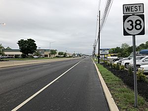
- Route 38 is the main road that runs east-west through the township.
- County Route 541 is the main road that runs north-south.
Lumberton has over 64 miles of roads, with the town, county, and state all helping to maintain them.
Public Transportation
- NJ Transit offers bus services. Route 317 connects Lumberton to Asbury Park and Philadelphia. Route 413 connects to Camden and Burlington.
- BurLink bus service has the B1 route, which travels between Beverly and Pemberton.
Airport
The Flying W Airport is located just about 1 mile southwest of the center of Lumberton.
Famous People from Lumberton
Many interesting people have lived in or are connected to Lumberton:
- Pat Delany: A former mayor of Lumberton.
- Ryan Finley (born 1991): A professional soccer player.
- Eric Lofton (born 1993): An offensive lineman in the Canadian Football League.
- Tyler Phillips (born 1997): A pitcher for the Philadelphia Phillies.
- Jack Pierce (born 1962): An Olympic bronze medalist in hurdles.
- Clifford Ross Powell (1893–1973): A politician who was acting Governor of New Jersey in 1935.
- Bobby Sanguinetti (born 1988): A professional ice hockey player.
See also
 In Spanish: Municipio de Lumberton (Nueva Jersey) para niños
 | Audre Lorde |
 | John Berry Meachum |
 | Ferdinand Lee Barnett |


