
Lyttelton, New Zealand facts for kids
Quick facts for kids
Lyttelton
|
|
|---|---|

Lyttelton inner harbour and township in February 2010
|
|
| Country | New Zealand |
| Region | Canterbury |
| Local authority | Christchurch City Council |
| Ward | Banks Peninsula |
| Community | Te Pātaka o Rākaihautū Banks Peninsula |
| Electorates |
|
| Area | |
| • Total | 4.52 km2 (1.75 sq mi) |
| Population
(June 2023)
|
|
| • Total | 3,180 |
| • Density | 703.5/km2 (1,822/sq mi) |
| Postcode |
8082
|
Lyttelton (also known as Māori: Ōhinehou or Māori: Riritana) is a busy port town in New Zealand. It's located on the north side of Lyttelton Harbour / Whakaraupō. This harbour is part of Banks Peninsula, very close to Christchurch. Lyttelton is on the eastern coast of the South Island.
For a long time, Lyttelton was seen as the "Gateway to Canterbury." This is because it was the main landing spot for ships bringing settlers to Christchurch. Today, it's a popular stop for cruise ships. It's also the main port in the South Island for moving goods. About 34% of exports and 61% of imports by value pass through Lyttelton.
In 2009, Lyttelton was named a Category I Historic Area. This means it has special historical or cultural importance. Sadly, many historic buildings were damaged in the 2011 Christchurch earthquake.
Contents
Where is Lyttelton?
Lyttelton is the biggest town on Lyttelton Harbour / Whakaraupō. This harbour is an inlet on the northwest side of Banks Peninsula. It stretches 18 kilometres inland from Pegasus Bay.
The town sits on the lower slopes of the Port Hills. These hills form the northern side of the harbour. They separate Lyttelton from the city of Christchurch. The steep hills act like a natural bowl, limiting how much the town can grow.
A tunnel through the Port Hills connects Lyttelton directly to Christchurch. Christchurch is about 12 kilometres northwest. The town of Sumner is about 6 kilometres northeast. You can reach it by Evans Pass. This road was closed after the 2011 earthquake but reopened in 2019.
Another town, Governors Bay, is 10 kilometres to the west. A regular ferry service connects Lyttelton to Diamond Harbour. Diamond Harbour is on the southern side of the harbour. The empty Ōtamahua / Quail Island is also in the upper harbour, southwest of Lyttelton.
How Lyttelton Was Settled

James Cook first saw Lyttelton Harbour / Whakaraupō in 1770. This was during his first trip to New Zealand. The first ship known to enter the harbour was the Pegasus in 1809. It was a sealing ship.
The Canterbury Association was formed in 1848. Its goal was to create a Church of England colony in New Zealand. George Lyttelton, 4th Baron Lyttelton led this group. The town was named after the Lyttelton family in 1858. The flat land near Christchurch was perfect for farming. This made Lyttelton an ideal port for the new colony.
Joseph Thomas was the Canterbury Association's chief surveyor. He was in charge of preparing the area for settlers. He first thought of putting the port at Rāpaki. He planned the capital, Christchurch, at the head of the harbour near Teddington. But these ideas didn't work out. Rāpaki was already promised to Māori people. Building the capital at the harbour head would have been too expensive.
Early surveys in Lyttelton were done by Thomas and Charles Torlesse. Most of the work was finished by Edward Jollie in September 1849. Jollie wrote in his diary about how the streets got their names. They were named after bishops. Lyttelton, being the first town, got the best names.
In August 1849, Lyttelton was officially declared a port. Pilgrim's Rock marks where European settlers first landed. Today, this rock is far from the sea. This is because much of Lyttelton's port area has been built on land reclaimed from the harbour.
In 1850, four ships arrived in Lyttelton Harbour. These were the Randolph, Cressy, Sir George Seymour, and Charlotte Jane. They carried the first 'Canterbury pilgrims.' After these ships arrived, Lyttelton's population grew to about 1,100 people. Over the next three years, 3,549 more settlers came to Lyttelton.
Lyttelton was once called Port Cooper and Port Victoria. It was the first settlement in the area in 1850. The name Lyttelton became official in 1858. It honoured George Lyttelton, 4th Baron Lyttelton, who was part of the Canterbury Association.
Lyttelton in the 1800s and 1900s


The Lyttelton Times was an important newspaper in Canterbury for 80 years. It was published from 1851 to 1929. Then it became the Christchurch Times until 1935.
On July 1, 1862, the first telegraph message in New Zealand was sent from Lyttelton Post Office.
On January 1, 1908, the Nimrod Expedition left Lyttelton Harbour. This expedition, led by Ernest Shackleton, explored Antarctica.
Apsley Cherry-Garrard, a member of the Terra Nova expedition, wrote about Lyttelton's importance. In his book, The Worst Journey in the World, he said Lyttelton was a welcoming home for Antarctic explorers. He noted that many expeditions, including Scott's Discovery and Shackleton's Nimrod, used the same quay in Lyttelton. New Zealand often gave supplies to these expeditions for free.
The Lyttelton Harbour Board was created in 1877. It managed the harbour. In 1989, it was split into two groups. One was a business, the Lyttelton Port Company. The other was non-commercial. The Lyttelton Port Company joined the New Zealand Stock Exchange in 1996.
The Great Lyttelton Fire of 1870
On October 24, 1870, a fire started at the Queen's Hotel on London Street. It quickly spread through the main part of Lyttelton. Prisoners from Lyttelton Gaol were let out to help fight the fire. Two-thirds of Lyttelton was destroyed. Thirty businesses and many homes were lost in the fire.
The Lyttelton Timeball Station
The Lyttelton Timeball Station was built in 1876. It started showing Greenwich Mean Time to ships that year. It was one of only five working timeball stations in the world. Sadly, it was destroyed by the June 2011 Christchurch earthquake. The building looked like a castle. It was high on a ridge above the port, with great views of the harbour. The tower has been rebuilt and was working again by the end of 2018.
Earthquakes of 2010–2011

The 2010 Canterbury earthquake damaged some of Lyttelton's old buildings. This included the Timeball Station. The town's roads and services also had some damage. But the port and tunnel quickly started working again. The damage was less than in Christchurch. This was because Lyttelton sits on solid rock, which helped lessen the shaking.
On February 22, 2011, a strong aftershock hit. It was a magnitude 6.3 earthquake. This aftershock caused much more damage in Lyttelton. It was very close to the town and only 5 kilometres deep. Some walls of the Timeball Station fell. Many homes and businesses were badly damaged. Several important old buildings, like the Harbour Light Theatre, had to be pulled down.
After the February earthquake, people thought about taking down the Timeball Station for safety. The head of Heritage New Zealand said they might rebuild it later. On June 13, 2011, another 6.3 magnitude aftershock hit. This brought down the tower and the remaining walls. Workers were getting ready to take it apart when it fell.
Much of Lyttelton's old architecture was lost because of the earthquakes. The damage was too bad to rebuild many places. By June 2011, six buildings on London Street and four on Norwich Quay were demolished. The town's oldest churches also collapsed. This included Holy Trinity, Canterbury's oldest stone church.
After Holy Trinity Church was demolished, St Saviour's Chapel was brought back to Lyttelton in 2013. This wooden chapel had been moved to Christchurch in the 1970s. The Anglican church in Lyttelton is now called St Saviour's at Holy Trinity.
People of Lyttelton
Lyttelton is considered a small urban area. It includes nearby places like Te Rāpaki-o-Te Rakiwhakaputa, Cass Bay, and Corsair Bay. The total area is about 4.52 square kilometres. In 2018, Lyttelton had an estimated population of about 3,000 people.
Most people in Lyttelton are of European descent (92.6%). About 10.1% are Māori. Many people (66.1%) said they had no religion. About 22.1% were Christian.
Many people in Lyttelton have a university degree (35.7%). The average income in Lyttelton was $39,200. Most people (54.3%) worked full-time.
How Lyttelton is Governed

In 2005, people in the Banks Peninsula District voted to join the Christchurch City Council. This happened on March 6, 2006. This change created a new seat on the Christchurch City Council for Banks Peninsula. It also created two Community Boards. These boards help local people have a say in how their area is run.
Getting Around Lyttelton
The town is connected to Christchurch by tunnels through the Port Hills. There's a railway tunnel and a road tunnel. The Lyttelton road tunnel opened in 1964. It was New Zealand's longest road tunnel until 2017. The Lyttelton rail tunnel opened in 1867. It is the country's oldest railway tunnel.
Lyttelton Port

Lyttelton has been the main port for the Canterbury and Christchurch area for a long time. The Lyttelton Harbour Board opened it in 1877. Later, it became the Lyttelton Port Company.
Between 1958 and 1967, the port was so busy that Kaiapoi, a town north of Christchurch, briefly reopened its port. This allowed smaller ships to avoid the crowded Lyttelton wharves.
In the 1970s, Lyttelton Port was chosen to be upgraded for container ships. The container facility opened in 1977.
A lot of coal from the South Island has been shipped from this port for over 100 years. The port also handles LP gas and petrol. It's a key port for energy shipments in the South Island.
Lyttelton is a regular stop for cruise ships. In November 2020, a new pier was opened. It can handle the biggest modern cruise ships.
Schools in Lyttelton
Lyttelton Primary School teaches students from Year 1 to Year 8. In 2023, it had about 280 students. The school was created in 2014. It was formed by joining Lyttelton West and Lyttelton Main schools.
Famous People from Lyttelton
- Bill Hammond (1947–2021), an artist
- Delaney Davidson (born 1972), an artist and musician
- Joe Bennett (born 1957), a writer
- Aldous Harding (born 1990), a folk singer-songwriter
- Marlon Williams (born 1990), a singer-songwriter and actor
- Mel Parsons (born 1981), a singer-songwriter
Lyttelton's Climate
| Climate data for Lyttelton (1991–2020) | |||||||||||||
|---|---|---|---|---|---|---|---|---|---|---|---|---|---|
| Month | Jan | Feb | Mar | Apr | May | Jun | Jul | Aug | Sep | Oct | Nov | Dec | Year |
| Mean daily maximum °C (°F) | 21.6 (70.9) |
21.0 (69.8) |
19.8 (67.6) |
17.2 (63.0) |
14.4 (57.9) |
12.1 (53.8) |
11.2 (52.2) |
12.2 (54.0) |
14.7 (58.5) |
16.6 (61.9) |
18.1 (64.6) |
20.1 (68.2) |
16.6 (61.9) |
| Daily mean °C (°F) | 17.7 (63.9) |
17.3 (63.1) |
16.0 (60.8) |
13.5 (56.3) |
10.6 (51.1) |
8.2 (46.8) |
7.4 (45.3) |
8.6 (47.5) |
10.7 (51.3) |
12.6 (54.7) |
14.3 (57.7) |
16.2 (61.2) |
12.8 (55.0) |
| Mean daily minimum °C (°F) | 13.8 (56.8) |
13.7 (56.7) |
12.2 (54.0) |
9.7 (49.5) |
6.9 (44.4) |
4.4 (39.9) |
3.6 (38.5) |
4.9 (40.8) |
6.7 (44.1) |
8.6 (47.5) |
10.5 (50.9) |
12.3 (54.1) |
8.9 (48.1) |
| Average rainfall mm (inches) | 41.9 (1.65) |
30.2 (1.19) |
44.6 (1.76) |
62.2 (2.45) |
55.5 (2.19) |
60.9 (2.40) |
65.4 (2.57) |
64.4 (2.54) |
32.8 (1.29) |
37.0 (1.46) |
34.4 (1.35) |
41.1 (1.62) |
570.4 (22.47) |
| Source: NIWA (rainfall 1961–2015 | |||||||||||||
Images for kids
-
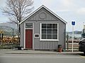
The historic telegraph office near the Port of Lyttelton
-
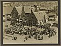
The Governor-General, Lord Bledisloe, and Lady Bledisloe visit Lyttelton, 24 November 1930
See also
 In Spanish: Lyttelton para niños
